
Facebook Twitter Instagram YouTube
Written on: December 3rd, 2018 in Wetland Assessments
By LeeAnn Haaf, Partnership for the Delaware Estuary
Sea levels are rising in the Delaware Estuary– we’ve already observed its effects. Over the last couple decades, we have seen dramatic losses of tidal marsh acreage and documented the death of trees bordering those tidal marshes. We know that the last hope for a lot of marsh might be their migration upslope into forests. We suspect, however, that the forest might have to give way first.
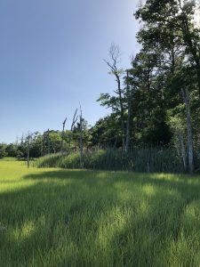
At only a few millimeters a year, the small changes caused by sea level rise are difficult to see, especially in forests. How do we study those small changes? Luckily, trees still surviving along the tidal marsh edge have been recording environmental conditions since they were saplings (Figure 1). We can learn from the past.
Trees in our area grow wood in rings every year. In the spring, this wood is light and as fall approaches, the wood becomes darker before the tree stops growing for the winter (Figure 2). In good years, the tree might grow more. Likewise, in bad years, the tree might grow only a little, or not at all. Finding patterns of bad growth years allows us to figure out what events caused the trees to grow less– perhaps because it was a drought, maybe insects were eating too many of their leaves, or perhaps there was a big storm that flooded the forest with salty water.
If certain forests get flooded with a lot with salt water, and trees grow less because of it, they will not be as quick to recover from future floods. Groundwater and soil moisture will change. This means that the forest, and the types of trees in it, will also change.
Sensitive trees will die off first, then only certain trees will remain. Eventually, the margin of the forest will contain no living trees and the soils will be wet enough for marsh grasses to move in. Bad news for the forest, but great news for the marsh! My research focuses on developing an understanding of how trees adjust to coastal hazards (like storm surge or sea level rise) and what this might mean for the future of these forests (and the marsh!).
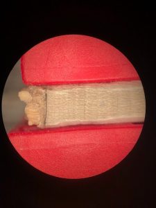
To study growth patterns in trees, a very small, narrow core is extracted from each study tree (Figure 3). So far, I have studied pitch pines (Pinus rigida) and American hollies (Ilex opaca), both of which are common near tidal marshes (elevations that are less than 3 m or 3.3 yd above sea level).
In the near future, I’ll expand these studies to red cedars (Juniperus virginiana) and maybe loblolly pines (Pinus taeda). I’m using x-ray fluorescence to help identify chemical elements that have been stored in the wood to pinpoint changes the trees may have experienced over time. Since salt water has unique chemicals compared to freshwater, we can get a sense if salt water flooding has become a more regular event through the tree’s life.
Tree Growth
The most major flooding event in the last decade was undoubtedly Hurricane Sandy, which made landfall in NJ at the end of October 2012. In the Delaware Estuary surge tides peaked well over 2.5 meters (2.7 yards) for two consecutive days. Many of the trees I’ve been studying grew less in 2013, the year after Hurricane Sandy. This seems perplexing, but the hurricane hit at the very end of the growing season. The salt water flooding likely impacted the soil into 2013, so that trees struggled most the summer following the Hurricane.
I also see less or no growth in 1996. This year was actually one of the wettest years on record, and in other nearby locations, trees did remarkably well. Could too much rain in 1996 have led to overly wet soil in these low lying forests? I’ll be studying this more to see if there’s a coastal-connection.
Tree Chemical Composition
Data from x-ray tests show trees can manage chemicals in their living tissues, and sometimes, whether conditions were good for uptake of micronutrients, like iron, calcium, and sulfur. When a forest floods with sea water, it introduces different components to the soil. This process can lead to an increase in the availability of iron, because of the extra moisture, as well as sulfur.
So far, I’ve tested four different trees using x-rays that varied from 4 to 34 meters from the marsh edge. Although these chemicals change from year to year, trees closer to the marsh seem to have consistently more iron and sulfur in their wood, but haven’t been growing any more or less than the other trees relative to their sizes. I’ll need more data to see if this patterns can be found in other trees, in other areas.
Conclusions
Although the overall short term prognosis of low lying coastal forests is still hazy, we’re working to better understanding the impacts of salt water flooding and sea level rise. So far, it looks like the changes to forest ecology caused by sea level rise are subtle. Trees can withstand quite a bit of environmental stress and are pretty resilient to change. It may take a couple decades to see more noticeable forest loss caused by sea level rise, but the impacts of storm surge could be more destructive and more immediate.
In general, forested areas may become wetter or swampier as sea levels rise, without very noticeable rates of tree stress or death caused by salt water. But if storm events bring and hold a lot of salty water in specific forests, we might see a lot of tree death in a short amount of time at that location (but maybe not others). If we cross walk both scenarios, we might see that forest loss and conversion into marsh will first happen mostly sporadically, starting where forests are most vulnerable to storm surge, then the marsh will slowly creep upslope where it can as sea level rises.
For more information about this project, please contact LeeAnne at lhaaf@delawareestuary.org.
Written on: December 1st, 2018 in Wetland Animals
By Kenny Smith, DNREC’s Wetland Monitoring and Assessment Program
Wetlands provide many services to us, like purifying our water, flood protection, and wildlife habitat. The animals that live in our wetlands can provide ample opportunities for outdoor activities like bird watching, fishing, and hunting. Delaware’s typical hunting and trapping seasons start in September and concludes at the end of January. Some of these species are migrants and pass through our wetlands on their way to wintering or breeding grounds, but most of these species are year round residents. Continue on to learn about some of the hunting and trapping that you can do in the wetlands of Delaware and potentially partake if these opportunities seem interesting to you.
Waterfowl
Starting with the most common hunting activity in our wetlands is waterfowl hunting, this consists of ducks, Canada geese, snow geese, and brant. These species use a diverse array of wetlands in the state from tidal wetlands to wooded depression wetlands. Wood ducks prefer non tidal wooded wetlands where they can nest in tree cavities, while snow geese will roost along tidal wetlands on their way to wintering areas.
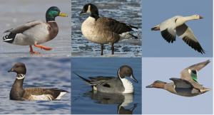
Most of the waterfowl hunting in Delaware is focused on the winter migrations of these birds, they leave the arctic breeding grounds and fly through Delaware on the way to wintering grounds in the southern U.S. Based on Delaware Fish and Wildlife mail surveys, the estimated harvest of ducks last year was just over 40,000 while Canada geese harvest was about 20,000, and snow geese was 11,000. This survey estimates that around 5,000 people enjoy waterfowl hunting in the states wetlands every year.
Muskrat
Muskrat are a year round resident of tidal salt marshes throughout the state, they create small mounds in salt marshes where they live. Muskrat are members of the rodent family but are actually omnivores and will consume vegetation but also frogs and fish.
They are one of the more common species to be trapped in Delaware and have been a Delaware tradition since colonization, with the meat and fur being the objective. The furs are sought after for clothing manufacturing, mostly in China, Russia, and Korea now that the North American fur demand has decreased significantly.
The meat from muskrat is a local delicacy and is often sold to local restaurants, local wild game dinners, or consumed by the trapper. If you are daring, some Delaware restaurants still serve muskrat and it can still be found at local butcher shops.
Non-waterfowl Gamebirds
The non-waterfowl gamebirds I am referring to are the rails, snipe, coot, and the gallinules and moorhens. Most of these birds migrate through Delaware, with rails being the exception being year round residents. Rails are a secretive marsh bird that inhabits our tidal salt marshes, with 4 different species being the target of sportsmen. The clapper rail is the most common rail found in Delaware, with the sora, the Virginia rail, and the King rail being the least common. Snipe are the next bird that hunters can target, and this is not a childhood prank. Snipe are actually a very common bird that hunters pursue. These birds usually can be found around open marshes and mud flats of our coastal wetlands. In the Delaware Fish and Wildlife mail surveys, they estimated that almost 400 rail and about 40 snipe were hunted last year.
Coots, gallinules, and moorhens are not as regional hunted as they are in other parts of the country but we do have them and they legally can be harvested. Coots can be found along marsh edges and can create large flocks on open water while moorhens and gallinules are more solitary and can be found along edges of marshes or ponds similar to rails.
Bullfrog and Snapping Turtles
Bullfrog and Snapping turtles are year round residents and can be found in many of our freshwater wetlands throughout the state. Bullfrog hunting is slightly different from any other hunting that happens in wetlands, you are allowed to do it at night, you don’t use a trap or gun, and the frog season runs from May 1st to September 30th. Instead you can use a light at night in the warmer months and hunt frogs with a spear or gig. Bullfrog hunting is very common in the southern U.S., and is still practiced by many in the Delmarva region. Bullfrog hunting can be a very inexpensive hunting endeavor since only a light and gig are required once you have the proper license.
On the flip side snapping turtle trapping is a very labor intensive adventure and you will need a lot more equipment. You can still try and use a spear, gig, or net but it is usually not as successful as using traps. The snapping turtle season runs from June 15th to May 15th and each turtle has to be a minimum of 11 inches on the curvature of the top shell. Bullfrog and snapping turtle are the 2 most common herpetological prey for hunters to pursue and are abundant throughout the state.
Highlighted were just some of the opportunities to hunt or trap in the wetlands of Delaware, check the Delaware Hunting guide for the proper seasons and laws before partaking in these activities. You will need to purchase a hunting or trapping license and tag along with a friend or family member and enjoy the outdoors. Below are some online resources to help you if you would like to try hunting or trapping in Delaware.
Written on: December 1st, 2018 in Wetland Animals
By William Koth, DNREC’s Delaware State Parks
Bryozoans may be one of our most overlooked and underappreciated animals. Known as “Moss Animals,” bryozoans are small, simple animals rarely growing more than 1/25th of an inch in length. However, most bryozoans form colonies that can vary greatly in number, form, and size.
Bryozoan Biology
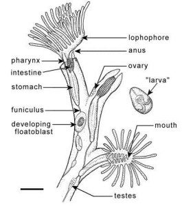
Each individual animal, or zooid, has a simple body style, usually round or oval in shape with a single opening that serves as both a mouth and an anus. Bryozoans lack any respiratory, excretory,or circulatory systems, but have a central nerve ganglion that allows the animal to respond to stimuli. They feed using small tiny ciliated (hair-like) tentacles that the surround the opening and push food through the it into the gut. In some species, and during certain life periods, these tentacles can be used for simple movement. Most species, however, spend the majority or all of their lifespan immobile.
How Many Kinds are There?
The vast majority of Bryozoan species are marine animals. Of nearly 5,000 species, less than 90 have been identified in freshwater environments, and only 24 freshwater species in North America (so far). In the freshwaters of Delaware, you are most likely to encounter the native Magnificent Bryozoan (Pectinatella magnifica). This colonial species forms jelly-like “green blobs” on underwater vegetation, branches and other structures. They may also form free floating round colonies. The small visible rosettes on the surface of the colony are groups of 12-18 individual animals.
How Do They Reproduce?
Although the Magnificent Bryozoan reproduces both sexually and asexually, the main way the colonies form is when the existing individual animal or zooid breaks away or buds asexually forming a twin. As they reproduce, they multiply into an ever growing sphere as the individuals point their mouths outwards to take advantage of available food. Meanwhile, the zooids excrete gelatinous material to give the sphere interior support.
Completely new colonies can also form asexually from small statoblasts (a group of cells encased in a hard covering to protect them from freezing or other harsh conditions). These statoblasts can float in the current, or settle to the bottom where they eventually grow into an individual zooid. These individual zooids can use their ciliated tentacles to move about in the water. They will eventually begin dividing and form a new colony. Smaller free floating colonies have been observed to use the ciliated tentacles in unison to move toward or away from stimuli.
What Do They Eat?
The Magnificent Bryozoan actively feeds on suspended organic material, zooplankton, and algae. In this way it can be considered a filter feeder and may, in some instances, increase water clarity. Individual animals on the colony are clear or opaque. It is speculated that the green color of the colonies stems from ingested algae.
Native or Invasive?
The Magnificent Bryozoan is native to Delaware, its native range extends from the Mississippi eastward to the Atlantic Coast from Ontario southward to Florida. Invasive outbreaks have been occurring in Europe since the 1930’s and west of the Mississippi since the 1950’s. The ecological impact of these invasions is still being studied, but colonies and groups of colonies have started to block some smaller waterways, ditches, and drainpipes. Colonies have been recorded up to 4 feet in Virginia, although the typical size found in Sussex County swamps, ponds and waterways is an inch to about a foot in diameter.
Encountering a colony of these animals can be a great experience. Trap Pond State Park staff receive several inquiries about these creatures each year. Most folks guess that they are some type of algae or fungus. Other guesses include freshwater jellyfish or fish eggs. Almost everyone is surprised to find out it is actually a colony of animals.
The staff recommend that you take full advantage of discovering one of these unique creatures. They do request that you not dislodge attached colonies, and not to keep them out of the water for more than a few minutes at a time. Lift it up, feel its surface, feel its weight, smell it. If you have a magnifying glass, take a look at the individual zooids on the surface. They are amazing animals that deserve a closer look and a little more appreciation!
Written on: November 27th, 2018 in Wetland Restoration
By Michael Bott, DNREC’s Watershed Assessment and Management Section
Have you ever wondered why there is so much submerged aquatic vegetation (SAV), also called seagrass, in the tidal waters of Virginia and Maryland but not in Delaware? This is a question many researchers and regulators in the state have been trying to solve and this year has finally given those involved some hope.
Unlike the Chesapeake Bay, the Delaware Bay is a very different ecological system and the naturally turbid waters do not support these large seagrass beds. Delaware’s Inland Bays on the other hand are similar to the Chesapeake and Coastal Bays of Maryland and Virginia and recently there have been some encouraging developments that someday this important ecosystem can flourish in Delaware.
In the Chesapeake Bay, ongoing largescale projects aim to restore and protect large seagrass meadows but historically Delaware’s restoration efforts have been small in comparison.
Why Should the state of Delaware Invest Time and Money Into Restoring Seagrass Anyways?
Just like wetlands provide countless services by purifying water, providing essential habitat and reducing storm impacts; SAV provides many of these same ecosystem benefits to the underwater world. Don’t forget, open water is a wetland too! Seagrass beds help to stabilize sediments, provide essential nursery habitat to aquatic species and improve recreational fishing and hunting opportunities in the waters where they grow.
As we continue to reduce nutrients such as Nitrogen and Phosphorus from entering our waterways, we should see less of the bad species of algae which covers the bottom blocking sunlight, thus creating more available habitat for SAV.
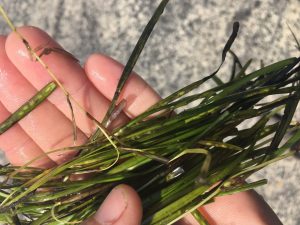
Eelgrass
When people talk about SAV, the first thing many think of are the iconic eelgrass beds of the lower Chesapeake and Coastal Bays of Maryland and Virginia, but not Delaware. Indian River Bay is home to the only known eelgrass bed in the state. This small bed has been clinging to life for over 15 years, but has been unable to expand its range much on its own.
Over the years, restoration efforts have tried to start small eelgrass beds in other portions of the Inland Bays, but so far these efforts have failed. Instead of trying to do the same exact thing and hoping for different results, the restoration efforts this year focused on trying to increase the size and health of the existing eelgrass bed. The hope is that if the current bed can grow, it will be able to produce enough seeds that could be transported by tides or wind to nearby areas to start new beds.
Widgeon Grass
In the higher salinity marine waters where eelgrass grows you can also find widgeon grass, an equally important species that can be found from coastal bays to roadside ditches. In the lagoons and canals of South Bethany, this species has slowly been taking a foothold in the Inland Bays. It has been known for several years that widgeon grass could be found in these canals at low densities, often near the dead ends and away from boat traffic.
In 2018 the widgeon grass beds exploded which was very exciting for those researchers and regulators mentioned above, but was not viewed with the same enthusiasm by residents who now were dealing with SAV clogging their boat motors instead of algae. This event provided an opportunity for all parties to work together to help educate those who thought this was just another nuisance algae. It was also a great opportunity to use the seed resource to try and establish an SAV bed in nearby Little Assawoman Bay.
How Can I Help?
If you want to help SAV return to the coastal waters of the State of Delaware, you can do your part in many of the same ways you help protect the more familiar wetlands you see every day. By maintaining healthy wetlands, harmful nutrients and other pollutants are removed before they enter the coastal waters and negatively impact seagrass beds.
It is also important to be mindful when boating in areas where SAV are found because a boat prop can quickly destroy all the hard work put into restoration. Currently a proposed regulation, if adopted, will prohibit clamming in SAV beds which are mapped by the state.
There are also groups working to protect SAV beds in freshwater tidal rivers of the state like the Nanticoke Watershed Alliance, where species such as wild celery and other freshwater vegetation can be found. By joining or supporting your local non-profit environmental organizations such as the Delaware Center for the Inland Bays, the Partnership for the Delaware Estuary or the Nanticoke Watershed Alliance, you can actively show your support for SAV and make sure your voice is heard.
Written on: September 12th, 2018 in Wetland Assessments
Alex Thomas, DNREC’s Wetland Monitoring and Assessment Program
When I got the call telling me that I had been offered the position of Wetland Field Technician for DNREC I was ecstatic. I would be working outside all summer, assisting on legitimate research projects and working with something I absolutely love. What I didn’t know at that time, was that field work comes with some….challenges.
There are some of the obvious ones like heat and thorny plants, however nobody told me that turkeys like to make nests in shrubs and jump out at you screaming bloody murder as you walk right next to them. Having this experience my second day on the job really set the tone for the rest of the summer.
I Love My Job Reason 1
Like I said before heat was an ever present challenge. I can recall one day we were in the Piney Point salt marsh with no shade, and a heat index of 110 degrees. (When you start sweating through your shirt 15 steps from the car, you know it’s going to be a great day.) Not to mention this particular salt marsh is littered with 3 foot holes hidden under tall swathes of Spartina alterniflora. Traversing this maze of hidden holes carrying all of our field equipment was an experience.
I can only imagine what we must have looked like to a random bystander. Seeing a team of scientists, completely drenched in sweat, walking three steps and sinking into hip deep mud with everything but the top of their heads covered by Spartina must have been hilarious to watch. Taking my first steps out of that marsh that day was nothing short of relief. I would also like to formally apologize on behalf of all of us who used the research van that day. We tried our best to keep it clean.
I Love My Job Reason 2
Everyday this past summer was one filled with excitement, even the days we spent primarily in the office. However, there is one day that will stand out above the rest. One day after finishing our last site of the day, Kenny and I were walking out of the woods back to the car to head back to the office. Everything was going smoothly until I felt a sharp pain in the back of my leg.
I immediately told Kenny that I think I walked through some stinging nettle and that he should be careful. A few steps later I feel more sharp pains and I start looking around frantically trying to find out what’s been stinging me. That is until I look at my finger and see a small black and yellow insect sitting there and the sharp pain I felt in the back of my legs starts to spread through my hand.
At this point I hear Kenny shout “YELLOWJACKETS!” and we start sprinting through the woods and trampling over patches of greenbrier and hurdling downed tree trunks like Olympic athletes, all the while being chased by a swarm of angry yellow jackets. Once out of the woods we were able to regroup and swat off the remaining bugs. All in all I was stung 17 times and had the pleasure of watching my calves and thighs swell up to almost twice their normal size.
In Conclusion
Even though these stories may sound scary or dangerous, I wouldn’t change a single thing that happened to me this summer! Summer 2018 has been a summer to remember. I will never forget the experiences I gained working for DNREC. Not only has this position prepared me for future field work positions, It has opened my eyes to the hard work that goes into assessing and preserving Delaware’s wetland habitats.
Lastly I would like to personally thank everybody that I have worked with this summer. This summer wouldn’t have been nearly as exciting or informative if it wasn’t for all of you. Thank you for allowing me to have this experience with all of you, keep up the good work
Written on: September 12th, 2018 in Education and Outreach
By Erin Dorest, DNREC’s Wetland Monitoring and Assessment Program
Wetland plants live a tough life. They are often under water for significant periods of time, meaning that they are frequently deprived of oxygen. Wetland plants also need to remain stable in the soil if they deal with fast moving water that ebbs and flows. Those that live in marine or estuarine areas are under even more stress simply because they need to be able to deal with saltwater! So how are wetland plants able to survive and reproduce under these difficult conditions?
Read on to learn about just a handful of the cool adaptations that some of Delaware’s wetland plants have that allow them to thrive in watery—and sometimes salty—habitats!
Saltmarsh Cordgrass (Spartina alterniflora)
If you’ve ever seen a saltmarsh in Delaware, then you’ve probably seen saltmarsh cordgrass. It grows in the areas in saltmarshes that are relatively low in elevation, meaning that they are flooded at every high tide (Figure 1). This plant has to deal with saltwater, and lots of it! It is also what’s known as a halophyte, which is a plant that can tolerate saltwater conditions. This grass actually has salt glands so that it can secrete all of the excess salt out (Figure 2). If you look carefully at its leaves, you can sometimes actually see the salt crystal secretions! Some other saltmarsh plants have this ability too, such as spike saltgrass (Distichlis spicata).
Arrow Arum (Peltandra virginica)
The name of this plant is fitting, because its leaves look like large arrowheads (Figure 3). Arrow arum likes to live in tidal freshwater marshes, lakes, and ponds where the water is shallow. This plant has evolved an interesting and effective way of reproducing while living in the water. The fruits, which look like greenish berries, fall into the water when they are ripe. Once they are in the water, the coating around the fruits swells and eventually bursts. After the coating bursts, the berries are capable of floating on the surface of the water. The berries can then release seeds, which sink to the ground below the water to eventually germinate and grow new plants. Because the berries can float on the water, seeds can disperse for plants to grow in new areas. Arrow arum knows how to work with the water!
Bald cypress (Taxodium distichum)
Bald cypress trees are deciduous conifers that grow in swamps and in floodplains along rivers and streams. They are southern trees, so Delaware is the farthest north that they grow naturally! How is it that a big tree can withstand so much water? Well, bald cypress trees have specialized root structures called pneumatophores—commonly called “knees”—that grow vertically out of the ground and water (Figure 4). Scientists believe that these knees help get air to roots that are under water. They might also help stabilize the tree in very watery conditions. A great place to go see bald cypress trees and their cool wetland adaptations in Delaware is Trap Pond State Park!
Cattails (Typha species)
Cattails are one of the most well-known wetland plants because they are widespread and easily recognizable with their brown, “tail-like” flowering structures (Figure 5). There are two species of cattail in Delaware; the broadleaf cattail is native (Typha latifolia), while the narrowleaf cattail (Typha angustifolia) is invasive. Both species are commonly found in marshes, shallow ponds, ditches, and wet meadows.
These areas often have standing water, and cattails have evolved a way to cope with that. Cattails have something called aerenchyma in their leaves, stems, and roots. Aerenchyma are basically open spaces that allow oxygen to travel from the air, to the leaves and shoots, and down to the roots and rhizomes (underground root-like stems) that are underwater. This keeps the parts of the plant that are submerged happy! They also help keep cattails upright in water because they keep the leaves fairly stiff. If you cut a cattail leaf open, you can actually see the aerenchyma in the leaves! Many other herbaceous wetland plants share this same adaptation to survive in wetland environments.
Next time you’re near a wetland, notice the plants and get curious about all of the amazing ways that they have adapted to live in watery conditions. After all, not just any plant can do it!
Written on: September 11th, 2018 in Wetland Animals
By Kurt Cheng, The Partnership for the Delaware Estuary
Upon hearing the term “freshwater mussel”, what do you think of? Is it that tasty seafood restaurant that serves them in white wine or steamed with garlic and parsley? If so, you’re probably not alone. But what if I told you we don’t eat freshwater mussels? This is the typical start to a conversation about those animals with two shells known as bivalve shellfish and the differences between them.
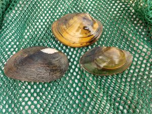
We often lump bivalves into the ‘we like to eat them’ category but that category is only for saltwater animals (e.g. hard clams, steamers, oysters, blue mussels, etc.). And while most of us know and love these salty critters, saltwater shellfish have (inedible) freshwater cousins that live in our freshwater streams and pond, nearly 300 species of them call North America home!
So now that we are clear on which shellfish we are talking about, just how selfish are they? One could say quite a bit considering they make fish carry their babies for them in order to reproduce.In other words, their babies are fish parasites. Talk about only thinking of yourself!
Once settled into the bottom of rivers and lakes, freshwater mussels get to work doing what they do best: filtering water. Just like their saltwater cousins, freshwater mussels are great at eating small particles in the water. This is because most bivalves are uniquely adapted to use their gills to breathe but also collect and eat the nutritious phytoplankton other animals can’t. This ability to filter Earth’s fresh water gives value to our freshwater mussels, even if we can’t enjoy them on the half shell.
So while freshwater mussels parasitize fish gills in order to survive, they return the favor in spades by providing valuable ecosystem services such as filtering the water so it’s cleaner for other plants and animals to enjoy. Perhaps they aren’t so selfish after all…
Learn more about freshwater mussels and how we can help recovery declining populations below!
www.mightymussel.com
www.delawareestuary.org/freshwater-mussels
Written on: May 18th, 2018 in Wetland Assessments
By Tom McKenna, University of Delaware Delaware Geological Survey
Working in tidal wetlands, we all know to watch the tide both for safety, sampling, and science reasons. But what do we really know about how tidal wetlands are inundated? The dynamics of the ebbing and flooding tide in deep (> 1 meter) tidal channels is a relatively well-known hydrologic process. However, our knowledge is limited for flow in shallower channels and on the marsh platform, partly due to limitations of our instrumentation. For example, does water flow over the banks of the larger channels before spilling over from smaller ones? Or, does water flow out of the landward end of channels before spilling over the sides?
Most models in the literature describe water spilling over the banks of larger channels. Collecting in situ data to quantify hydrologic processes, including inundation of marsh platforms, is difficult due to soft sediment, shallow water, tides, and the spatially dynamic nature of shallow water flow. Environmental thermography is a technique that can overcome these obstacles by imaging inundation of tidal flats and the marsh platform from a ground-based remote sensing platform. A thermal imager records a time series of images by sensing temperature with time in every image pixel over a broad area. Imaging is best from a high platform like a ground-based tower or helikite (balloon with wings and string) that can stay close to one position. Drones can supplement the work but are limited by short flight times (half-hour). What makes this technique so amenable to tidal wetlands is the ability to collect imagery at time-scales (minutes/hours) below those of the dominant stresses on the system (semi-diurnal tides, day/night), unlike thermal sensors on aerial or satellite platforms.
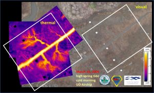
Two examples are shown in the figures: one from a decommissioned airship (Figure 1), and one from a bucket truck (Figure 2). The images from March 2009 are a snapshot taken during flood tide in the marsh along Brockonbridge Gut in Kent County. Warmer temperatures (water) are orange and cooler temperature (marsh and mudflat) are purple. The inundation pattern is not visible in the visual image, but it is clear in the thermal image that tidal water flows into distinct channels then “feathers” out near the headwaters of these channels.
Figure 2 shows a sequence of images collected over one hour in June 2009 in a marsh along the Murderkill River in Kent County. Warmer water is yellow, orange, and red, and cooler marsh is blue and black. The flooding tide first enters the area from a ditch, seen as the yellow linear feature on the right side of the image at 9:45 pm. But the bulk of flow, seen as warmer water entering from the lower right corner at 10:15 pm, is from another ditch that is out of the image to the right.
Currently, the nature of shallow water flow on the marsh platform remains largely uncharacterized. The capabilities of both models of hydrodynamic flow on the platform and models of salt marsh evolution (e.g. accretion/deposition, formation of channels) are outpacing the data collection required to validate those models. One of our goals over the next few years is to use environmental thermography to help constrain some numerical models that explicitly model flow on the marsh platform. This will provide resource managers with better information on the dynamic hydrologic processes in tidal wetlands and relationships to sediment accretion/erosion, biogeochemistry and water quality, ecological function, and impacts from anthropogenic activity, climate change, and rising sea level.
Written on: March 7th, 2018 in Wetland Assessments
By Erin Dorest, DNREC’s Wetland Monitoring and Assessment Program
As you might imagine, sea level rise can increase water levels and cause more flooding. As that happens, salt water starts to move further inland. It may start to creep into freshwater areas through a process called saltwater intrusion. Higher waters can endanger coastal communities, while saltwater intrusion can affect our drinking water and agricultural lands. But we, WMAP, are also looking at the issue from our wetlands lens. How can sea level rise—and in turn saltwater intrusion—impact freshwater wetland habitats?
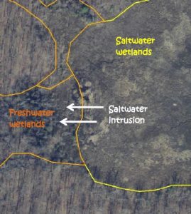
Freshwater wetlands that are located near saltwater wetlands will likely be some of the first areas to experience saltwater intrusion and increased flooding. If these wetlands begin to experience the effects of sea level rise, there are several possible outcomes:
We want to know which of these scenarios is happening to freshwater wetlands in Delaware!
Methods
To try to answer this question, we chose 15 study sites throughout Delaware where freshwater wetlands are next to saltwater wetlands. Those are the areas where we are most likely to see increased flooding and/or saltwater intrusion from rising sea levels.
We selected sites by comparing old and current state wetland maps. This allowed us to see where parts of freshwater wetlands may have started experiencing change. We also used old and current aerial imagery to select sites. Aerial imagery allowed us to see where vegetation changes, such as tree or shrub death, have begun to occur. We placed four sampling points at each field site in order to best describe the whole area that might be in transition. At each point for each site, we gathered data about water salinity, vegetation, and soils.
Field Results
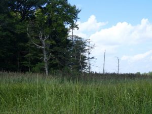
What we have seen so far is that there are quite a few standing dead trees along edges of many forests that are next to saltmarshes. This shows that some forest edges are starting to die off as they face increased flooding and/or saltwater intrusion, as we expected. We have also seen that the common reed is moving into a lot of these areas where trees are dying off. This suggests that invasive Phragmites is colonizing areas before native saltmarsh plants have a chance to.
A lot of our fieldwork for this study was done in the 2017 field season, but we will be finishing up in the 2018 field season. Stay tuned for more detailed results and our conclusions!
Written on: March 7th, 2018 in Wetland Assessments
By Kenny Smith, DNREC, Wetland Monitoring and Assessment Program
Wetlands provide many vital benefits to the State of Delaware, like habitat for all kinds of plants and animals, improved water quality, and erosion control. Another benefit that wetlands provide is flood control. Wetlands have the ability to collect and store storm waters and lessen flooding down river, and we are working on a project to study just that.
Riverine Wetlands
No matter where you are in Delaware, there is at least one wetland located within a mile of you. Wetlands do not always have water at the surface. For this reason, we determined a wetland to be an area where water is held in the top 12 inches of the soil or higher for two or more weeks. This particular project focused on riverine or floodplain wetlands. Riverine wetlands are found along non-tidal creeks or rivers surrounding the banks of the creek. One of their main benefits is that they absorb and hold onto any excess water in the system. Creeks and rivers without wetlands along them can have significant damage or erosion to nearby properties from storm events.
Monitoring Water Levels in Riverine Wetlands
Our program, WMAP, installed three wells in an area along the Blackbird Creek in the Blackbird Forest in 2015. We placed the wells throughout the riverine wetland to figure out what the water in the soil is doing at the site to then determine how much flood protection that particular wetland can provide. The wells collect data on how much and often the wetland is soaked with water. Every four months we go back to the site to download the data and do any maintenance.
Does the Blackbird Forest Wetland Offer Flood Protection? And How Long was the Wetland Wet?
The 2016 data showed that this particular wetland had water in the top 12 inches of the soil or higher for for about 179 days throughout the year (if you combine the days together, that is almost six months)! The water level was even above the ground surface on four different days. Looking at what months were the wettest, the data also showed that the majority of the water was held for 162 days from December 15, 2015 to May 27, 2016. This information supports the fact that wetlands hold more water in the winter and early spring months.
Can the Wetland Soak Up Water?
To figure out how much flood protection the Blackbird Forest riverine wetland provided, we compared the water depth of our wells with a downstream water level gauge in the creek. The thought process is that as precipitation falls the creek water level will rise. Once it has rained, snowed, or sleeted enough, the water level will reach the creek banks and overflow into the wetland. Then, the wells should show the increase of water in this wetland.
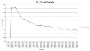
We have had a few large precipitation events since we installed these wells and can visualize how much water these wetlands can hold in these events. One example of this was around December 25, 2015. The site received about two inches of precipitation and in response the creek water gauge increased by 27 inches and our well water levels increased by 19 inches. Another example was on July 6, 2017. The site received approximately seven and a half inches of precipitation, the creek water gauge rose to almost 33 inches above the normal level and our wells reported an increase in 45 inches.
Can the Wetland Slowly Release the Water?
The well data also showed that this wetland surrounding the creek was able to quickly soak up the overbank flooding and slowly release it. The water level in the wells usually increased exponentially faster than decreased after the precipitation events. If the wetland hadn’t been there, it is likely the water would have quickly rushed down creek causing flooding or erosion damage in both of these rain events.
Future Monitoring Efforts
We will continue to monitor our Blackbird Forest site to further explain the function of riverine wetlands to the landscape. In addition, we also have three wells in a flat wetland in the Ted Harvey Wildlife area in Dover, DE where we have been collecting data. Here we will look at the relationship between flat wetlands and precipitation.
Want more information about this project? Contact kenneth.e.smith@delaware.gov or 302-739-9939.