Facebook Twitter Instagram YouTube

Written on: September 15th, 2021 in Wetland Assessments, Wetland Restoration
By Alison Rogerson, DNREC’s Wetland Monitoring and Assessment Program
Back in July we explored the status and trends of stormwater ponds in Delaware. This time around we’re digging into how and where Delaware ‘gained’ wetlands between 2007 and 2017, according to DNREC’s recent Statewide Wetland Mapping Project (SWMP) update.
How does one gain a wetland? Where did they come from? Weren’t we taught that wetlands take years and years under water-logged (saturated) conditions to create hydric soils and then grow water loving (hydrophytic) plants? Well, that is true- so the answer is- it depends. First, let’s take a look at the overall numbers and then explain where they came from.
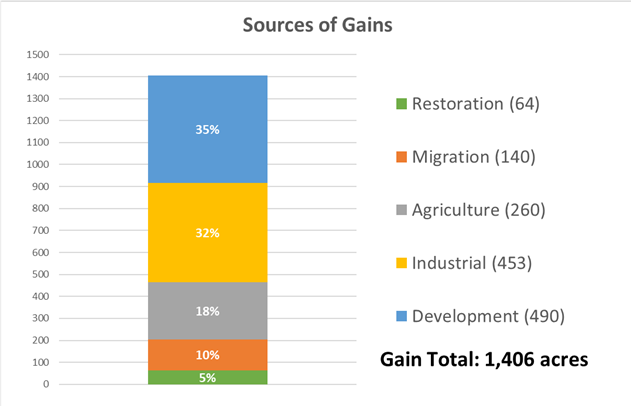
Between 2007 and 2017, this project estimated that Delaware gained 1,406 acres of wetlands. This is about half as much as Delaware lost in this timeframe and represents just 0.4% of statewide wetland acreage in 2017. Half of those gained wetlands were in Sussex County, where most gains are attributed to stormwater ponds tied to development. In total, 90% of 1,406 acres gained were manmade, for a few reasons described below.
Better Mapping
Wetland maps and acreage are based on remote sensing- by computer basically- using photos taken from the sky combined with other maps such as elevation and soils to make a very educated guess at where functioning wetlands exist. As photo quality improves, as supporting information is updated, and as the computer technology evolves the ability to ‘find’ wetlands increases- so wetlands that may have already been there in the past but were not detected previously would count as a ‘gain’. They were already there, we just got better at seeing them.
Conditions
When wetland maps are created based on a snapshot in time- one set of aerial photos taken in the spring before leaves get in the way- the conditions that year can make a difference. Photos taken in a wet year when there has been a lot of rain may show greater wetland extent but during a dry year can show shrunken or fewer wetlands- which is why supporting information like elevation and soils are key to balance out what may just be fluctuations due to weather.
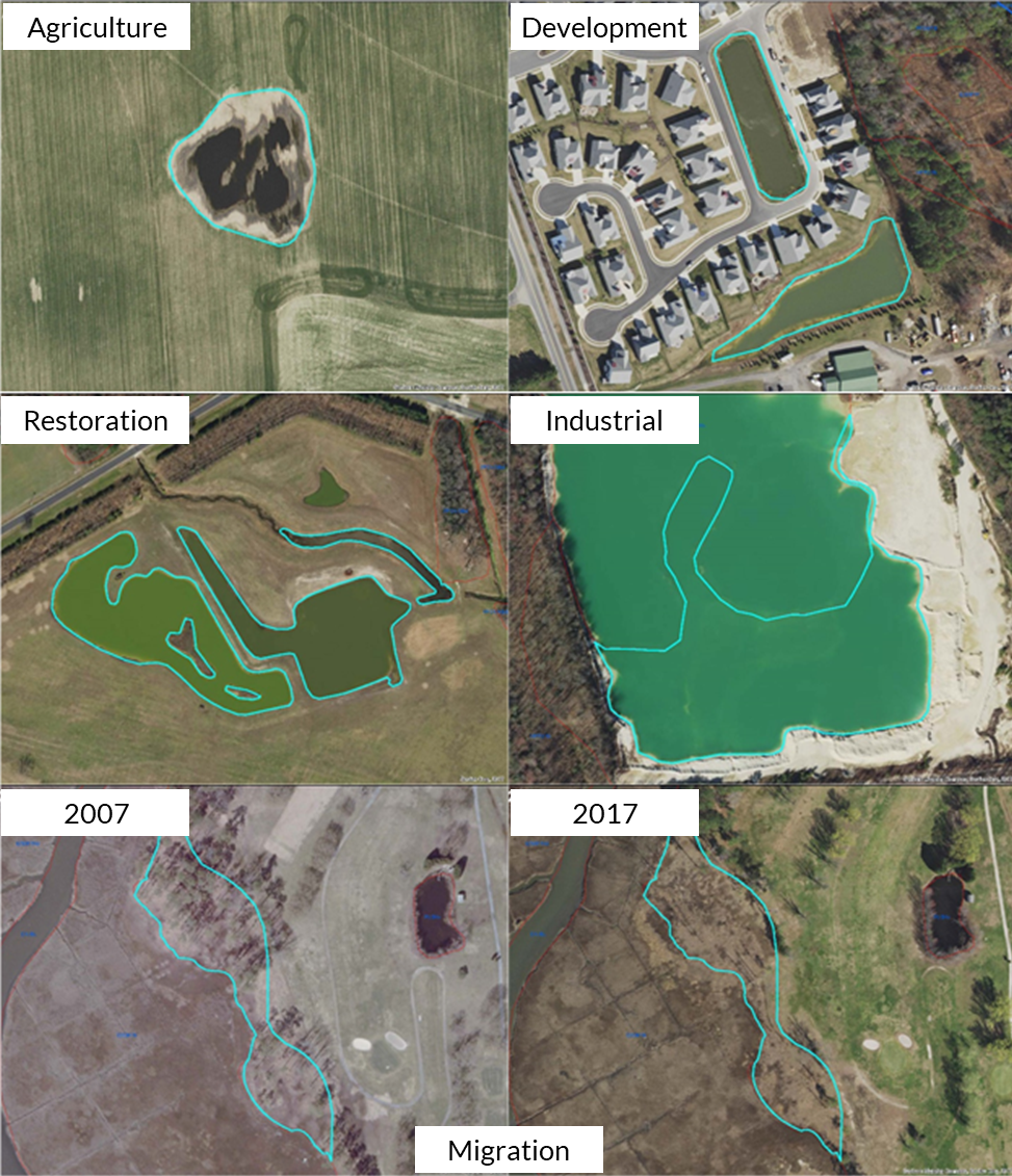
Restoration (Middle left photo)
In some cases, new wetlands really have been gained. Wetland restoration projects around the state can change the landscape by creating new wetlands or bringing a degraded wetland back to its former glory. Wetland creation often occurs in former ag fields and are often done to offset, or mitigate, wetland impacts somewhere else. Restoring degraded wetlands may involve restoring natural water flow to a previously farmed wet field. Large restoration projects can be picked up in wetland mapping and counted as a gain. In this project, wetland gains by restoration made up 5%, or 63 acres.
Industrial Sources (Middle right photo)
On the other hand, sometimes gains due to landscape changes are not true gains in functioning wetlands, such as mining for dirt and sand materials to use in construction. The borrow pits created during excavation often fill with water, creating large pools which can be picked up as a wetland gain but really do not provide functional value and should be counted separately. Industrial sources accounted for a third of wetland gains statewide.
Development (Top right photo)
As readers learned in July, the prominence of stormwater ponds in Delaware has continued to increase. As the housing boom continues with fervor, so does the creation of stormwater ponds, which every new neighborhood or commercial building requires. As previously mentioned, these ponds capture storm water but lack greatly compared to natural, vegetated wetlands. Another third of wetland gains were related to development through creation of retention and stormwater ponds.
Agriculture (Top left photo)
One source of both wetland loss and gain is due to or from agriculture. Wetland pockets are converted and are incorporated into tilled farm fields. Over time, crop production in those pockets may decrease. Farming a wetland is not easy, and if production is not worth the seed and fertilizer that goes into it, a farmer may opt to abandon trying to farm a former wetland pocket. When those pockets are no longer being tilled and mowed they revert back to grassy vegetation and can be picked up as a wetland gain.
Migration (Bottom left and right photos)
As we all know, Delaware is being impacted by sea level rise at an increasing rate, which prompts coastal wetlands to creep away to remain higher. This trend, called marsh migration, led to many small wetland gains along wetland upland boundaries. Forest edges have become wetter, leading to trees dying and wetland vegetation moving in. About 140 acres were natural gains associated with marsh migration.
As you have read, wetland gains come in many forms; some are more authentic than others. Some have potential for function, some do not. At the end of the day, though, wetland losses far exceed wetland gains so we have more work to do to tip the scales to the positive side. More on wetland losses next time!
Delaware's Governor
State Agencies
Elected Officials
General Assembly
Delaware Courts
State Employees
Cities & Towns
Delaware State Code
State Regulations
Business First Steps
Phone Directory
Locations Directory
Public Meetings
Voting & Elections
Transparency
Delaware Marketplace
Tax Center
Personal Income Tax
Privacy Policy
Weather & Travel
Contact Us
Corporations
Franchise Tax
Gross Receipts Tax
Withholding Tax
Delaware Topics
Help Center
Mobile Apps
E-mail / Text Alerts
Social Media

Built by the Government Information Center
©MMXVIII Delaware.gov

