Facebook Twitter Instagram YouTube

Written on: September 8th, 2021 in Living Shorelines, Wetland Restoration
By Joshua Moody, Partnership for the Delaware Estuary
Since 2014, the City of Lewes, Delaware has been actively renovating the downtown waterfront park and shoreline along the Lewes-Rehoboth Canal, including native plant landscaping, playground features, walking paths, and educational signage. This work has been a part of a larger plan by the city to provide public open space, enhance tourism, and provide greater opportunity for public engagement. The little league baseball field located next to the Lightship Overfalls museum is a prominent feature of the public area along the canal, serving as a community gathering and recreational area. A narrow fringe of salt marsh separates the ballfields from the canal, helping to protect them from flooding by absorbing water. However, flood protection is not the only service that the salt marsh provides. The band of intertidal vegetation serves important roles for many fish, birds, and other animals that call Delaware home. Juvenile fish feed and take refuge from predators in the flooded vegetation and in the intertidal creeks, birds nest and forage for food among the grass and along the adjacent mud flat, and shellfish settle intertidally to filter food (and pollutants) from the water while simultaneously fertilizing plants and providing habitats for many smaller invertebrates. Additionally, when water floods the salt marsh, the plants can take up nitrogen and trap sediments that can have negative water quality impacts. The eroding salt marsh was not just bad for the ballfields, but for the local ecology as well.
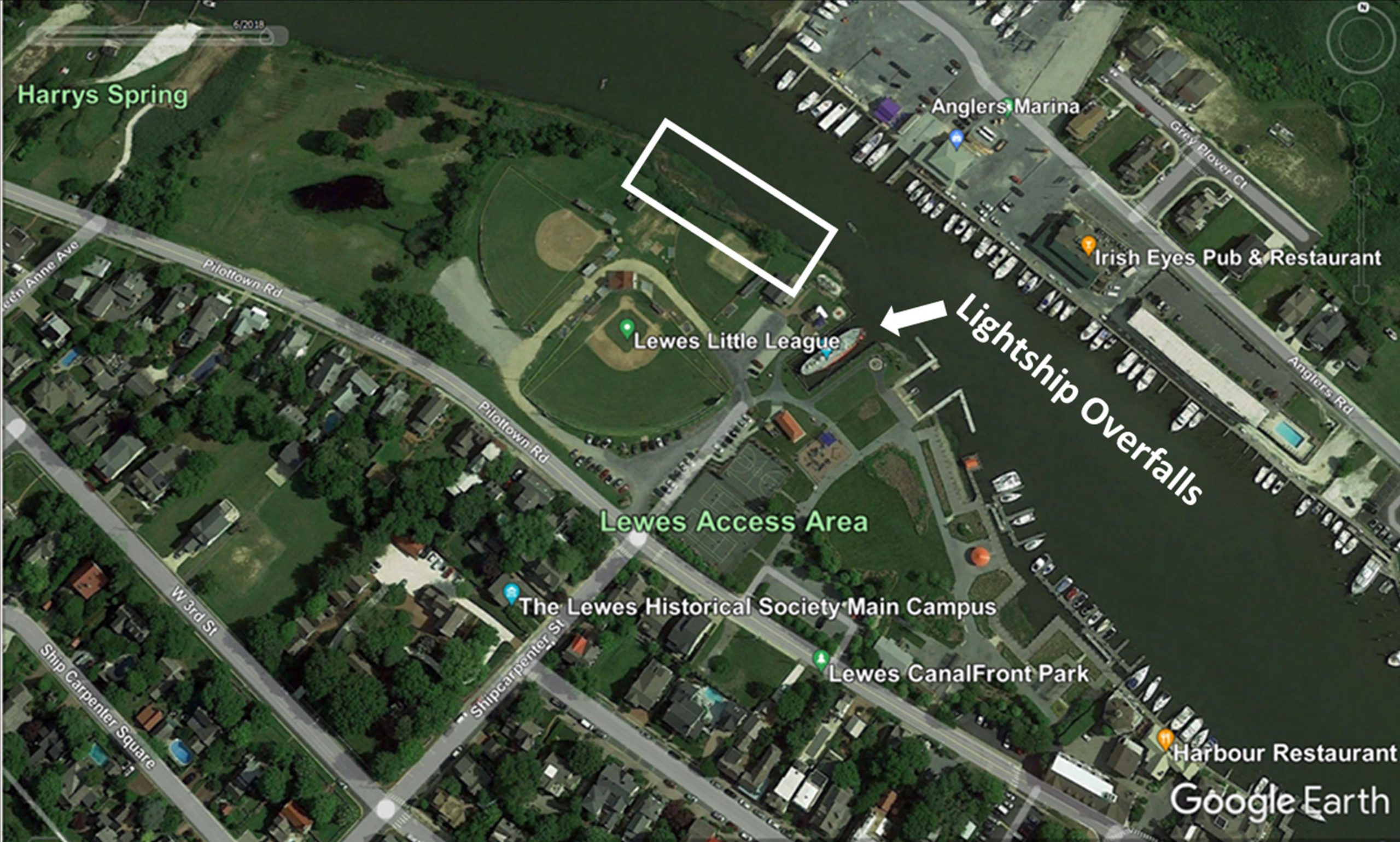
Stopping erosion while supporting natural habitats is not always an easy task. Many of the techniques historically used to stop erosion, such as bulkheads and rip rap, can harm wildlife and reduce usable habitat. Water reflecting off bulkheads can impact the valuable mudflat habitat in front of them, and rip rap can make it difficult for many motile species, such as turtles and horseshoe crabs, to move from the water up into the marsh. Additionally, these types of structures can ultimately sever the connection between the water and the land, reducing the intertidal salt marsh habitat and many of the important services it provides. In 2007, the Partnership for the Delaware Estuary and the Rutgers University Haskin Shellfish Research Laboratory began exploring new living shoreline techniques to provide erosion control with ecological uplift along the Maurice River in New Jersey. The goal of these efforts was to develop a methodology that capitalized on the naturally stabilizing structure of shellfish beds, both oyster and mussel, to reduce erosion. These efforts were of interest to the DNREC Wetland Monitoring and Assessment Program (WMAP), who approached PDE in 2013 to discuss collaborating on a living shoreline project. The renovation efforts with a focus on native habitats that were just beginning along the Lewes waterfront made the ballfields an ideal location to test a living shoreline (Figure 1).
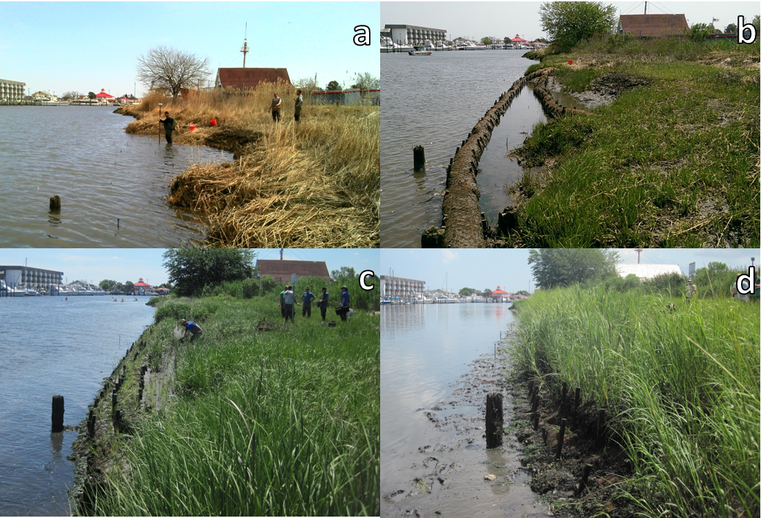
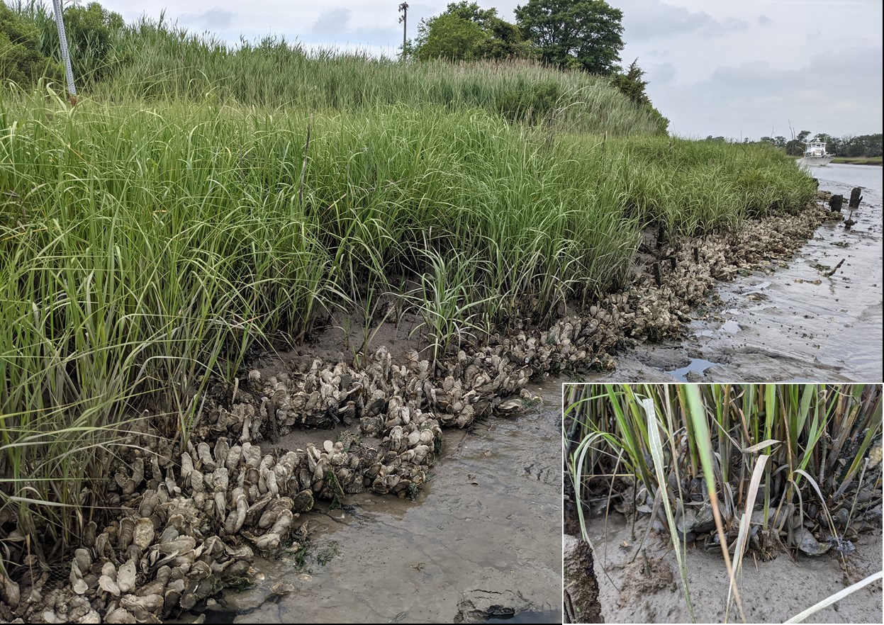
The living shoreline design focused on meeting the dual goals of erosion control and habitat uplift, employing ecologically beneficial materials placed to develop the proper ecological conditions for salt marsh plants and shellfish to thrive. Coir, or coconut fiber, logs were used to shape the waterward edge and build elevation, while recycled oyster shell bags provided protection to the logs and would serve as a home for developing oyster and ribbed mussel communities. In April of 2014, a series of shell bag-lined coir logs were installed in a cusp formation along 92’ of the eroding shoreline (Figure 2b), which was left to trap sediment and build elevation over the following five months, until a second tier of coir logs was added to build additional elevation in October (visible in Figure 2c). Achieving the correct elevation is very important to create the appropriate habitat for the native salt marsh plants that require a certain amount of flooding to survive and prosper. Purchased and salvaged Spartina alterniflora, the native salt marsh cordgrass, was planted in the living shoreline area as trapped sediment continued to build elevation throughout 2014. By the spring of 2015 the planted and pre-existing vegetation were moving into the newly built area (Figure 2c), which was almost completely vegetated by August 2016 (Figure 2d).
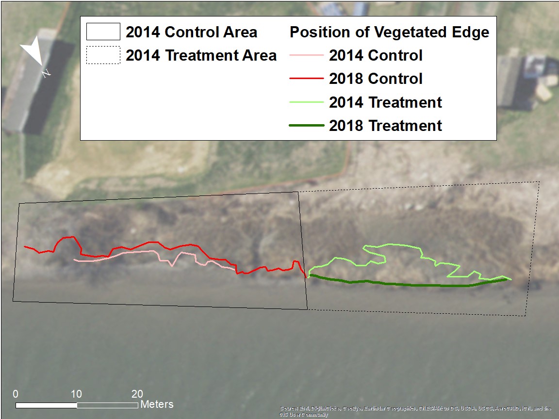
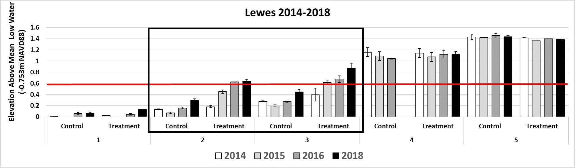
Over subsequent years, annual monitoring quantified the effects of the living shoreline on the horizontal and vertical position of the vegetation, the vegetation’s health, and the shellfish community, relative to no action at a paired control site 50’ to the east. The coir logs remained intact until 2017, when two sections deteriorated and were replaced with recycled oyster shell bags. Overall, the living shoreline was successful in reestablishing vegetation for an overall gain of 1,447 sqft of salt marsh habitat, while its paired control continued to erode (Figure 3). Importantly, the living shoreline was able to build and retain the appropriate elevation for vegetation persistence (Figure 4), and provide suitable oyster and ribbed mussel habitat via the shell bags, which have been densely colonized (Figure 5).
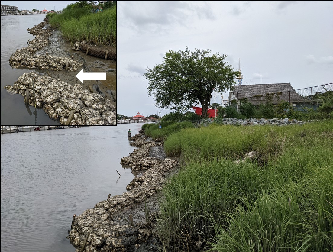
By 2020, the continued erosion along the adjacent control area became dire and encroachment on the Little League fields was imminent. In addition to the erosion, in 2020 a 50’ x 5’ section of marsh separated from the existing marsh and slid onto the mudflat. While the calved vegetation gave the illusion of waterward marsh growth, this unstable sediment and vegetation was highly vulnerable to erosion. Although worrisome, this situation provided an opportunity – if this material was trapped at its current position, over time it would stabilize and grow vertically to help rebuild much of the eroded salt marsh at the control site without relying on the need for outside fill. Concurrently, the USFWS Delaware Bay Estuary Project office had expressed interest in supporting a local living shoreline effort. PDE and DNREC WMAP presented the idea to expand the successful 2014 effort, which was well received, and a new project team was born. Collaboration between the three entities resulted in a design with the goals to stabilize and advance the vegetated edge at eroding area to the extent of the 2014 living shoreline and to provide additional habitat for the now robust oyster and ribbed mussel populations. The Lewes Historical Society (LHS), which owns the property, was very interested in stabilizing the salt marsh using ecologically friendly techniques, and supported the project team obtaining the appropriate state and federal permits. The new design was informed by the successful 2014 installation, while incorporating lessons learned from new living shoreline installations at other locations. As bagged shell has shown great longevity in maintaining position over time, while also providing shellfish habitat and retaining sediment across a multitude of installations, recycled oyster shell bags were selected as the primary construction material.
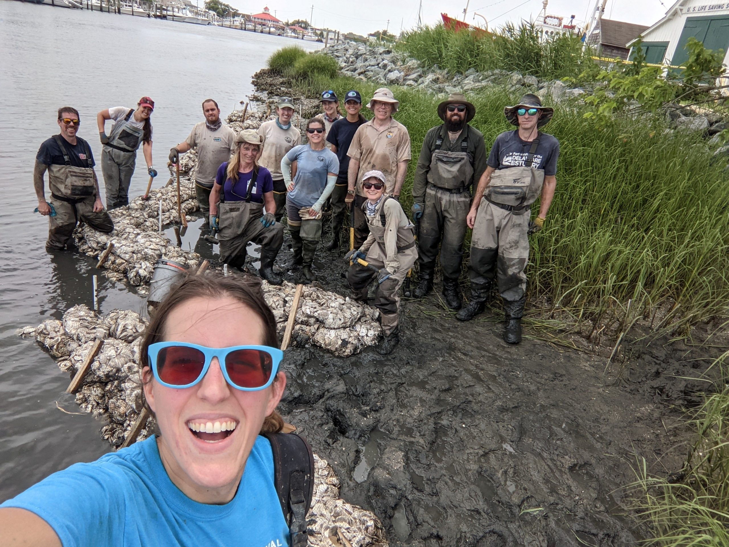
On June 21, 2021 over 1,200 shell bags were placed along 165’ of shoreline and positioned to create five sinuous, overlapping structures between 20’ and 40’ in length and 1.5’ high, with 5’ gaps between them, by PDE, DNREC WMAP, and USFWS DBEP (Figures 6 and 7). The curved formations allow for water drainage and faunal passage while interrupting direct wave passage between structures to the shoreline. Additionally, each structure contains at least one perpendicular “finger” to interrupt water transport and scour along the waterward edge. Finally, at four locations between the shell structures and the existing marsh edge, coir fiber logs were installed to help retain sediment. Annual monitoring will continue along the entire length of the living shoreline, encompassing both the 2014 and 2021 installations, and a seven-year pre-installation data set, will help the project team understand the impact of the newly deployed materials on the ecology. The project team is currently working with the LHS to develop informative signage to educate the many visitors to the waterfront on the goals and ecological importance of living shoreline efforts.
Delaware's Governor
State Agencies
Elected Officials
General Assembly
Delaware Courts
State Employees
Cities & Towns
Delaware State Code
State Regulations
Business First Steps
Phone Directory
Locations Directory
Public Meetings
Voting & Elections
Transparency
Delaware Marketplace
Tax Center
Personal Income Tax
Privacy Policy
Weather & Travel
Contact Us
Corporations
Franchise Tax
Gross Receipts Tax
Withholding Tax
Delaware Topics
Help Center
Mobile Apps
E-mail / Text Alerts
Social Media

Built by the Government Information Center
©MMXVIII Delaware.gov

