Facebook Twitter Instagram YouTube

Written on: September 17th, 2020 in Wetland Assessments
By Erin Dorset, DNREC’s Wetland Monitoring and Assessment Program
Most of our wetland assessments throughout the years have been in central and southern Delaware, but in the summer of 2017, our Wetland Monitoring and Assessment crew went north to perform wetland condition assessments at 116 wetlands in the Red Lion watershed. From protocol updates to navigating wetlands in a highly developed landscape, we certainly faced many new challenges. This year we finished analyzing the data from that summer, and now we can truly reflect on what we have learned!
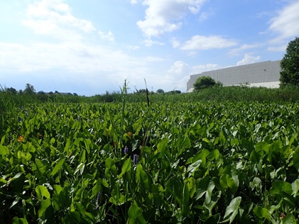
A tidal freshwater wetland in the Red Lion watershed that is bordered by industrial development.
Our tidal wetland assessment protocol (MidTRAM) was originally designed only for salt marshes. However, Delaware is also home to tidal freshwater wetlands. Tidal freshwater wetlands are inherently different from salt marshes in many ways, such as water salinity and plant community. Such differences made our original protocol inappropriate for assessing tidal freshwater marshes.
Knowing that we would encounter many tidal freshwater marshes in the Red Lion watershed, we decided to update our tidal assessment protocol to incorporate those wetlands. To do so, we examined slightly different features for freshwater and saltwater tidal wetlands. We then graded them all on the same scale and combined them into one category for tidal wetland condition analyses. We were able to pilot test our updated tidal protocol (MidTRAM v.4.1) and learn a lot more about tidal freshwater wetlands in the process!
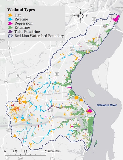
Wetland types in the Red Lion watershed based on 2007 state wetland maps.
The Red Lion watershed is in northern Delaware in New Castle county, encompassing 72 square miles. It includes part of the C&D Canal in the southern part of the watershed and Lums Pond State Park in the western part. In addition, it includes the populated areas of New Castle, Delaware City, Red Lion, and part of Bear.
In terms of land cover, the watershed is dominated by development, agriculture, and wetlands. Based on 2007 wetland maps, over half (54.9%) of wetlands are tidal, including saltwater wetlands (estuarine) and tidal freshwater wetlands (tidal palustrine). The rest of the wetlands are non-tidal flats (24.9%), non-tidal riverine wetlands (13.7%), or non-tidal depressions (6.5%). Overall, the watershed scored very poorly, receiving a D+ letter grade. Riverine and flat wetlands were in the best condition, with both wetland types receiving a B-. Depression and tidal wetlands were in much worse condition, receiving a D and a D-, respectively.
Northern Delaware is more heavily developed than most of central and southern Delaware, which is dominated largely by agriculture. This makes northern Delaware a very different landscape within which to study wetland condition. In fact, we found that development, clearing for future development, and highway construction were by far the leading causes of wetland acreage loss in the Red Lion watershed between 1992 and 2007. Most wetlands that were gained during that same time period did not have any vegetation and were surrounded by development, limiting their ability to provide useful functions.

Example of a mapped non-tidal wetland loss (outlined in green) to development between 1992 (left) and 2007 (right).
As of 2017, the only other watershed that we had assessed in this urbanized area was the Christina River watershed. It came as no surprise to us that the Red Lion watershed was very similar to the Christina River watershed in terms of overall wetland condition. We found that 21% of wetlands were minimally stressed, 36% were moderately stressed, and 43% were severely stressed. The Red Lion and Christina River watersheds both had the highest proportion of severely stressed wetlands of any other watersheds that we’ve assessed.
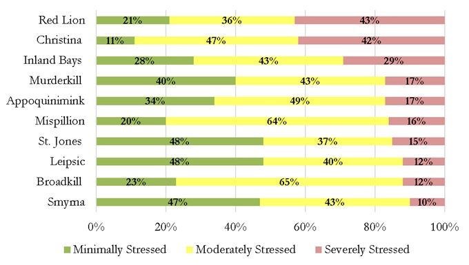
Wetland condition comparisons among watersheds in Delaware.
One of the most widespread problems that we observed across all wetland types in the Red Lion watershed was the lack of natural surrounding land, or buffer. Development, roads, mowing, and other disturbances were commonly found in landscapes surrounding Red Lion wetlands. Without natural buffers, wetlands are more likely to experience issues like pollution and lack of suitable wildlife habitat. Tidal wetlands will also be unable to migrate inland as sea levels rise.
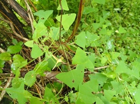
A flat wetland in the Red Lion watershed covered in the invasive plant mile-a-minute.
Like we have seen in many other watersheds, all wetland types in the Red Lion watershed suffered from the presence of invasive plant species, such as the European reed (Phragmites australis) and Japanese honeysuckle (Lonicera japonica). Invasive plants crowd out native plant species and reduce habitat value for wildlife that rely on native plants.
Many tidal wetlands also suffered from things like low plant species diversity and low marsh stability. Some non-tidal flats were ditched, causing water levels in those wetlands to be lower than they would be naturally. Numerous depressions contained nutrient indicator plant species. This suggests that many depressions may have had unnaturally high levels of nutrients within them from pollutant sources.
As you can see, wetlands in the Red Lion watershed are in poor overall condition and they need your help! You can manage invasive species on your property so that they don’t expand into nearby wetlands. If you need help identifying plant species, you can download the Delaware Wetland Plant Guide for free! Other important things that you can do are to preserve or restore wetlands and wetland buffers on your land. You can also incorporate nature-based landscape designs where appropriate, such as living shorelines, rain barrels, or rain gardens. Additionally, you can help curb effects of pollution by limiting use of fertilizers and pesticides on lawns and gardens, washing cars on grass, and properly disposing of pet waste and chemicals.
Want to know more? Check out our newly released Red Lion Watershed Report and Report Card!

Written on: September 17th, 2020 in Education and Outreach
By Amanda K. Pappas, Delaware State University

Dinophysis acuminata preserved in Lugol’s iodine solution. Photo taken during the National Center for Marine Algae and Microbiota Harmful Algae Taxonomy Course at Bigelow Laboratory.
Dinoflagellates are a group of microscopic, mostly unicellular aquatic protists that are members of the plankton community. They live in fresh and marine waters, spanning the tropics to the arctic. Fossil records of dinoflagellates exist that are hundreds of millions of years old, so they have had some serious time evolving to their environments and the diversity of adaptations within the group showcases that.
Dinoflagellates are defined by two whip-like appendages they use to move called flagella. One wraps around the body for propulsion and the other extends out from the body for steering. The “brain-like” organelle of the dinoflagellate cell, the nucleus, is relatively large compared to those found in other unicellular creatures and looks like a human fingerprint. Dinoflagellates have a distinguishable cell covering known as a theca that is either “naked” for some or covered in an armor of cellulose in others.
Most are benign and mind their own business floating around providing food and oxygen to all, but some have the bonus of an ability to produce toxins. Toxin production in dinoflagellates is thought to be a means of avoiding predation and can be so potent they can cause illness in humans. This is an area our Dinophysis makes its debut.
The genus Dinophysis consists of more than 100 species and they are too small to see without a microscope; 165 Dinophysis acuminata (D.a.) cells lined up “top to bottom” can fit across the diameter of your trusty #2 pencil eraser. In the 1970s another member of this genus, Dinophysis fortii, was identified as the culprit for sickness linked to contaminated shellfish in Japan through its production of toxins: okadaic acid and derivatives. The shellfish beds had to be shut down to harvests and this invisible miscreant has become a specimen of study almost everywhere.
In 2008, Texas experienced a similar situation Japan had, and the culprit that time was D.a. The economic hit communities take by closing recreational shellfish harvesting sites even for a season can lead to millions of lost dollars in lost venue. Areas with shellfish aquaculture industries are especially vulnerable and closures could lead to economic collapse for some areas reliant on the seasonal consumption of shellfish by tourists and national or worldwide sales.

2016 DSP World Map from the US National Office for Harmful Algae Blooms https://hab.whoi.edu/maps/regions-world-distribution/
The toxins produced by some members of the Dinophysis group lead to an illness known as Diarrhetic Shellfish Poisoning (DSP); can you guess the major symptom of the illness? Diarrhea along with other uncomfortable symptoms (i.e. pain, cramping, vomiting, chills, fever) occurs following consumption of filter feeding shellfish such as mussels, clams, scallops, cockles, and oysters that have accumulated okadaic acid in tissues. DSP toxins also promote tumor growth and may increase gastrointestinal cancer risk in humans with prolonged exposure. DSP toxins are not degraded by cooking and poisoning usually comes on quickly, within 30 minutes to a few hours after consumption and symptoms last 3-4 days. Symptoms can be severe or not and may go unrecognized as DSP poisoning due to the nonspecific symptoms in less severe cases. Aren’t you glad someone is keeping track of these things?
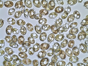
Dinophysis acuminata in culture. (Photo by A. Pappas and A. Williams, 2018)
My study site is in the Delaware Inland Bays, a group of shallow water bodies in south- eastern Delaware, with a flourishing oyster aquaculture industry. Torquay Canal, a dead-end residential canal up in the north- western corner of these bays, is a site with a history of D.a. bloom events. It is important to note this area is closed to shellfish harvest and no aquaculture takes place there.
D.a. is considered a harmful algae bloom (HAB) species. A bloom event of this species occurs when cell densities reach 20,000 cells per liter of water (cells/L) or more. Torquay Canal has had blooms in the millions! Whether a bloom event is harmful or not depends on the species and toxicity. Sometimes, high cell densities can be low in toxins and low cell densities may be high in toxins. Prey consumption, location, and strain all seem to influence toxin production in D.a. Increases in cell densities are known to occur due to increases in nutrient runoff (nitrogen and phosphorus) from land via fertilizers, faulty septics/sewage, and industrial discharge. Changes in wind direction, sunlight, temperature, and prey availability also contribute to increases in cell densities of D.a. Bloom events typically occur for this species at my study site during the spring and summer. I wanted to know if they were still there in the winter.
Some dinoflagellate life cycles involve a stage where the cell can encyst, creating a sort of encapsulation that allows the dinoflagellate to enter a state of dormancy quiescence during times where adequate resources are not in abundance, most often during winter months. These cysts are deposited in sediments, and act as inoculum to can start up future bloom events, and can be carried to other locations through wind and wave action. Whether or not D. acuminata produces cysts is not known; no one has seen one yet. So, I sought to answer, or at least scratch the surface, of a related question: Is D. a. present within the sediments of Torquay Canal during winter months?
I started by collecting sediment and water samples at Torquay Canal every month for two years. The water samples I took for nitrogen and phosphorus analysis. Every time I sampled, I recorded information about the current water condition, like temperature, dissolved oxygen, pH, and salinity. Dinoflagellate cells are packed with DNA, so instead of looking for something no one has ever seen, I extracted DNA from sediment samples using a chemistry kit made just for the application.
After I had my DNA, I used a common molecular method called PCR (Polymerase Chain Reaction) to determine if the DNA I extracted belonged to Dinophysis. Basically, you add DNA to a mixture of enzymes, reagents, and known segments of DNA you can purchase from a laboratory. The known segments are called primers and they bind to either side of the DNA segment you are attempting to replicate that is unique to the organism you want to determine the presence of. The mixture is heated up to break the double stranded helix of DNA in two strands and the primers and reagents all do what they naturally do: breaking, binding and copying through the heating and cooling. The process continues until billions of copies of the DNA segment you are looking for end up in your little test tube or not. It’s chemistry!
Then comes a trip to the post office to send out the samples to a sequencing lab to make sure you have what you aimed for. The sequencing lab can determine the amino acid profile of your PCR product so you can check that to a database for accuracy. Yes, there are databases full of DNA profiles for all kinds of organisms!
I am now analyzing results to determine if there are correlations between the results of the sediment analysis and nitrogen and phosphorus data. The information obtained through this project will strengthen the harmful algae monitoring program in Delaware and add to the limited knowledge of D. a. within the Delaware Inland Bays. I am looking forward to the mysteries we will uncover about this amazing creature!
Acknowledgements:
This project is directed by Dr. Gulnihal Ozbay (Advisor) at Delaware State University and Dr. Kathy Coyne at Delaware Sea Grant.
The NOAA LMRCSC provides funding for this project and is supported by the National Oceanic and Atmospheric Administration Educational Partnership Program with Minority Serving.
Institutions award NA 16 SEC 4810007. The USDA provided funding for this project under the USDA NIFA Capacity Building Grant Award 201606642. Delaware Sea Grant provided funding for this project under award R/HCE 32.
Dr. Ed Whereat (The University of Delaware Citizens Monitoring Program), Amanda Williams, Detbra Rosales, and Jen Wolny contributed to this project.
Delaware's Governor
State Agencies
Elected Officials
General Assembly
Delaware Courts
State Employees
Cities & Towns
Delaware State Code
State Regulations
Business First Steps
Phone Directory
Locations Directory
Public Meetings
Voting & Elections
Transparency
Delaware Marketplace
Tax Center
Personal Income Tax
Privacy Policy
Weather & Travel
Contact Us
Corporations
Franchise Tax
Gross Receipts Tax
Withholding Tax
Delaware Topics
Help Center
Mobile Apps
E-mail / Text Alerts
Social Media

Built by the Government Information Center
©MMXVIII Delaware.gov

