Facebook Twitter Instagram YouTube

Written on: December 9th, 2020 in Wetland Assessments
Guest Student Writer: Sandra Demberger, M.S., recent graduate,
Villanova University
Boaters, kayakers, and bird watchers are drawn to salt marshes for their quiet beauty. Wildlife, ranging from great blue herons to tiny fiddler crabs, and marsh grasses rustling in the soothing breeze, all draw recreators to these coastal systems. But did you know, these seemingly tranquil systems are hard at work providing valuable ecosystem services?
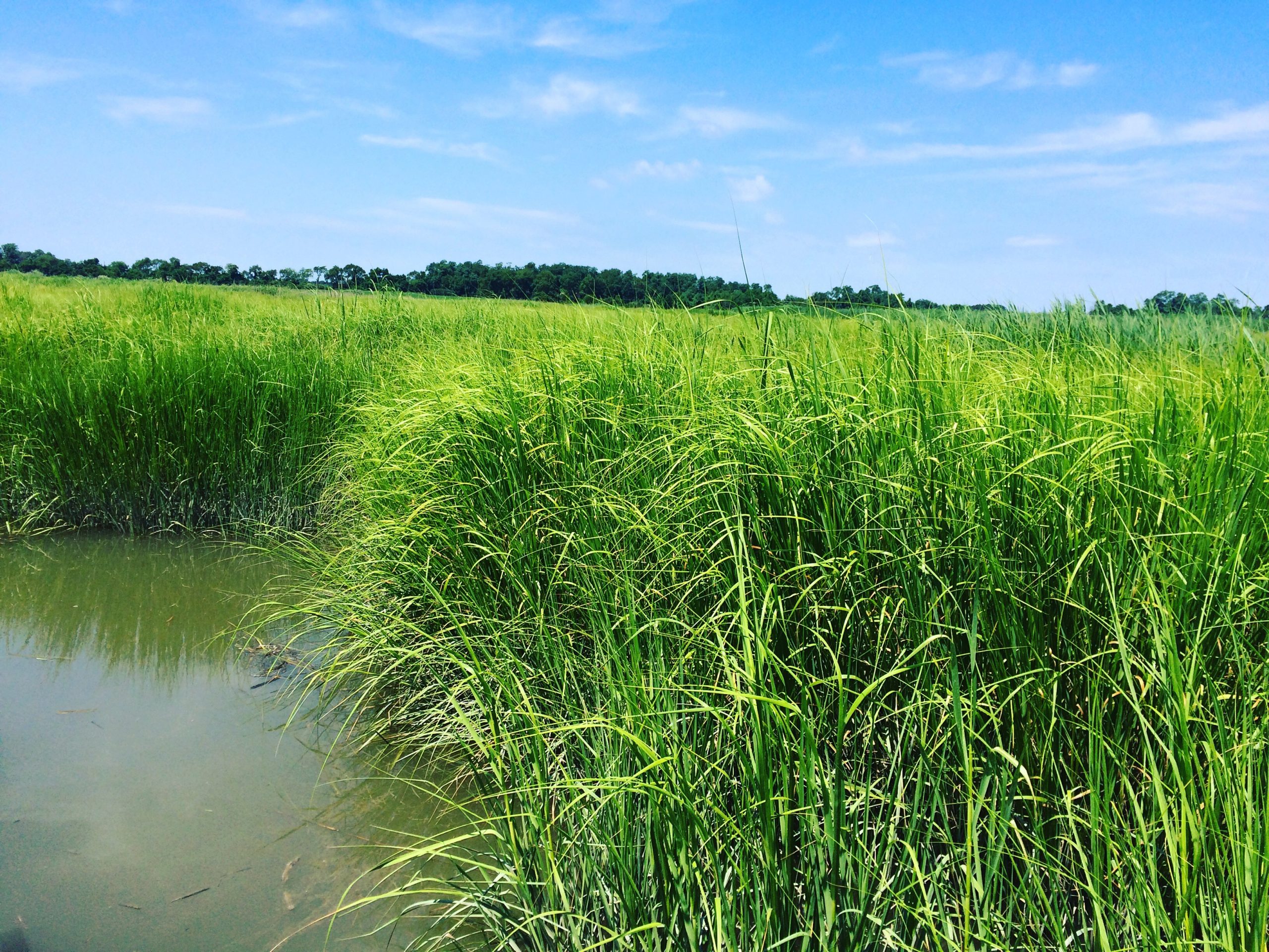
A tidal wetland in the Delaware Estuary.
An ecosystem service is a natural process that contributes directly or indirectly to the well-being of the human population¹. Salt marshes provide many ecosystem services. Some of these services include coastal protection from storm events, water filtration, and nursery habitat for economically important fish species. Additionally, scientists increasingly recognize salt marshes for their role in removing carbon from the atmosphere and storing it long-term in their soils. That process is called carbon sequestration.
All these valuable services are provided by the marsh free of charge!
Carbon dioxide is a major contributor to global climate change because it functions as a greenhouse gas. Greenhouse gases trap heat in our atmosphere, much like a garden greenhouse does. Consequently, these gases warm up our planet at an unnatural pace. This process results in what is commonly referred to as global warming, and, in turn, global climate change (a shift in climate as a result of warmer temperatures). Unfortunately, all of us are releasing carbon dioxide into the atmosphere by doing daily activities like driving our cars and heating/cooling our homes.
While we humans are putting carbon dioxide into the atmosphere, salt marshes are working hard to remove it!
Carbon sequestration is a valuable ecosystem service, naturally removing carbon from the atmosphere and locking it away in plant material for generations. While many ecosystems can sequester carbon, salt marshes have proven to be the experts. Salt marshes can sequester carbon at rates 10 times higher than other terrestrial wetland systems². Less carbon in the atmosphere means less greenhouse gases, and, ultimately, reduced global warming.

Beautiful tidal wetland in the Delaware Estuary.
Carbon sequestration is a cycle with three key components: plant material, suspended sediments (think mud and sand particles floating in the water), and very slow natural sea level rise. Here is the basic carbon sequestration cycle:
1. Salt marsh plants need sunlight, water, and carbon dioxide to grow. This process is called photosynthesis. The carbon absorbed during photosynthesis is stored in the plant matter.
2. Over time, marsh plants will die and their plant matter, still full of carbon, will build up on the marsh surface. While some of this plant material will be decomposed by microbes in the marsh, a portion will remain.
3. Twice a day the tidal waters will bring suspended sediments onto the marsh surface during high tide. The still living plants will slow tidal waters, allowing suspended sediments to settle out of the water column onto the marsh surface.
4. These suspended sediments will bury the plant material (from step 2) as well as the carbon stored within it, and elevate the marsh surface.
5. Slow, natural sea level rise allows the marsh to gain elevation at a pace that can keep up. This cycle has continued over millennia to form deep carbon deposits.
Over thousands of years, this cycle has formed carbon-rich deposits reaching six meters in depth³. The rates of salt marsh carbon sequestration may vary by region due to factors like the length of the plant growing season and the amount of suspended sediments deposited on the marsh surface. Regardless of the pace of carbon sequestration, salt marshes are worth protecting for this important ecosystem service.
It is often challenging to convince non-salt marsh lovers of the importance of these systems. To many, salt marshes are buggy and muddy areas with no real use. Defining ecosystem services–in particular, their monetary value–helps people understand their importance.
Therefore, some economists have dedicated their careers to estimating the monetary value of ecosystem services. They have developed the social cost of carbon as a way to measure the monetary value of carbon sequestration in salt marshes. The social cost of carbon is the sum of all the costs of one additional ton of carbon dioxide being emitted into the atmosphere. Some of these costs may include more severe storms and wildfires, which destroy communities and reduced agricultural yields straining our food supply. The exact value may vary due to different assumptions and uncertainties about the impacts of climate change in the future (click here for more information).

Me doing fieldwork in a salt marsh in the Delaware Estuary.
My Master’s research was related to this idea of valuing ecosystem services of salt marshes. Specifically, I focused on carbon sequestration in the Delaware Estuary. I found that the Delaware Estuary sequesters over 306,000 Mg Carbon dioxide annually. In other words, the Delaware Estuary removes the equivalent of carbon dioxide emitted from 66,109 passenger cars in one year. But this is still hard to comprehend. So, let’s apply the social cost of carbon!
The Delaware Estuary prevents about $18.32 million in damages every year by sequestering carbon from the atmosphere (using a $ 59.83 social cost of carbon value). If salt marshes stopped sequestering carbon tomorrow, society could expect to endure over $18 million in damages per year. This is pretty impactful!
This basic monetary valuation, in this case just for a single ecosystem service, helps provide context to an otherwise complex natural process.
Accelerated sea level rise is a serious threat the salt marshes. Marshes unable to gain elevation at a pace that keeps up will drown and erode away. That, in turn, would cause large carbon deposits to be released back into the environment, contributing, once again, to global climate change.
Living shorelines, beneficial reuse of dredge material, and other restoration projects are essential to protecting marshes, and the large amounts of carbon stored within them, from accelerated sea level rise. Valuing carbon sequestration and other ecosystem services may help land managers and practitioners gain funding and support for these types of conservation efforts. Additionally, understanding the value of carbon sequestration, and the many other ecosystem services, may help conservationists discourage the development of retail and housing on these valuable landscapes.
References
1. U.S. Environmental Protection Agency. 2009. Valuing the protection of ecological systems and services. A report of the EPA Science Advisory Board. EPA, Washington, D.C., USA.
2. Bridgham, Scott D., Patrick J. Megonigal, Jason Keller, Norman Bliss, and Carl Trettin. 2006. The carbon balance of North American wetlands. Wetlands. 26:889–916. https://link.springer.com/article/10.1672/0277-5212(2006)26[889:TCBONA]2.0.CO;2
3. Chmura, Gail L. 2013. What do we need to assess the sustainability of the tidal salt marsh carbon sink? Ocean and Coastal Management83: 25–31. doi.org/10.1016/j.ocecoaman.2011.09.006

Written on: December 9th, 2020 in Education and Outreach
By Kate Fleming, Delaware Sea Grant
When crab pots* are lost or abandoned at sea, they remain in the water, free to continue to capture blue crabs as they are designed to do. They can also capture other animals like diamondback terrapin and summer flounder. Since derelict crab pots are not tended by anyone, the animals that become trapped inside will eventually die. As such, these forgotten pots can lead to continued and needless mortality in our ecosystem in a process called ghost fishing.
Gear loss and abandonment is fairly common in pot-based fisheries. That’s because pots are designed to be placed in the water and left alone for days at a time before being checked on. This comes with some inherent risk for accidental loss and sometimes obstacles can come up that hinder a timely return.
Here in Delaware, blue crabbing is an important commercial industry. It is also a popular recreational past-time that leads to the capture of over 1 million blue crabs each year. Could it be that we have ghost crab pots scattered across the bottom of Delaware’s Inland Bays, where only recreational crabbing takes place? Based on the work I have been doing with University of Delaware Professor, Dr. Art Trembanis, I can say with confidence that the answer is yes, yes we do.
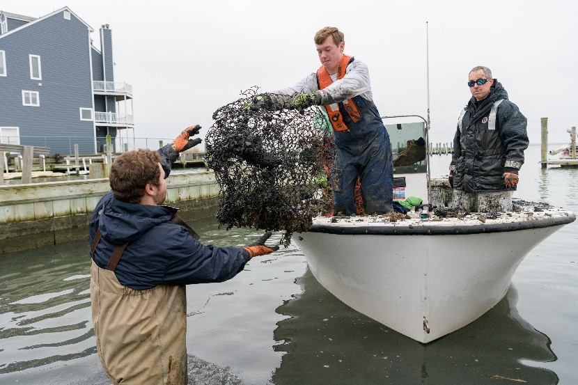
Grant Otto (graduate student in the Coastal Sediments, Hydrodynamics, and Engineering Lab) and Chris Petrone Delaware Sea Grant Extension Director) hand off a derelict crab pot (Evan Krape UD)
This shouldn’t be particularly surprising given the ubiquitous nature of this type of marine debris. However, the shallow murky waters of our Inland Bays offer an effective hiding place. Last winter** we used a commercial-grade side scan sonar to document over 560 derelict crab pots submerged beneath the surface of just under 250 acres of Rehoboth Bay. This represents some of the highest densities of derelict crab pots that have been estimated in Chesapeake Bay, which supports one of the largest blue crabbing fisheries in the nation. We followed our surveys up with a pilot removal effort. We recovered about 100 derelict crab pots in just a couple days. (Read more about our pilot removal project here!).
Today our project team has grown to include University of Delaware graduate student Jen Repp. It also includes Delaware Sea Grant’s Fisheries and Aquaculture Specialist, Dr. Ed Hale. Our sights are now set on Indian River Bay. Jen and Art are initiating side-scan sonar surveys any day now. Plus, I am in the thick of planning Derelict Crab Pot Round-Ups across three days this January and/or February 2021. The whims of the weather will determine the specific dates!
Compared to last year’s pilot project, we plan to quadruple our survey area. We will be removing 10 times the number of derelict crab pots over the next two years, aided by volunteers with boats that are willing to wield a grappling hook and help us on the water. We’ll be staging out of Holts Landing State Park and keeping our fingers crossed for flat calm seas and the balmiest of winter temperatures!
Interested in helping out? We are targeting volunteers that can bring and crew their own boats. Click here for more information and to register a team, or contact our Coastal Ecology Specialist at haywoobl@udel.edu with any questions!
If you don’t have a boat but would still like to contribute, there are a couple other volunteer opportunities that will likely come up with this project:
– We will be giving a subset of our recovered pots to the Partnership for Delaware Estuary (PDE) to be repurposed in a living shoreline experiment. Following the removal, the Center for Inland Bays (CIB) will be coordinating volunteers to transport these pots to Wilmington, DE where PDE is located. Interested volunteers can contact CIB Volunteer Coordinator, Nivette Perez-Perez at nperezperez@inlandbays.org.
– We will likely be looking for volunteer assistance to refurbish any remaining crab pots this spring or summer so that they can be reused for education and outreach. If that sounds like fun (I think it does), please reach out (haywoobl@udel.edu) and we’ll get you on the list.
One of the most common questions I get when I talk about derelict crab pots in Delaware’s recreational blue crab fishery is: Why? Why would a recreational crabber abandon their pots? Our work doesn’t actually focus on answering that question. But, I often like to point out that DNREC-Enforcement has an existing program to curb crab pot abandonment in our state. The program issues notices and then seizes pots that have not been tended within three days as is required in Delaware. They actually let me collect data through this program. It has been an outstanding opportunity to learn about recreational crab pot abandonment rates. I’ve also learned a lot about Turtle Bycatch Reduction Device (TBRD) compliance (a little more on TBRD’s below).
With that program in place, I prefer to ponder the issue of accidental pot loss. I suspect it is an important contributor to the presence of derelict crab pots in our Inland Bays. If gear is rigged with old, degrading line it can be more susceptible to breakage by rough weather or boat propellers. Likewise, buoys assembled from hollow materials are more likely to fill up with water and sink if punctured. We have recovered quite a few derelict crab pots that had bleach bottle and bumper “floats” still attached that were no longer doing their jobs.
These are accidents of course. But, I do think there are things that recreational crabbers and boaters can do to minimize the potential to lose a pot. These are things like:
-Use those white foam bullet floats in lieu of bleach bottles or bumpers
-Change out your lines each year
-Use line that sinks
-Keep your eye on the weather forecast before you set your pots
-Update your tending plan if it looks like a storm is coming or you have to go out of town
Likewise, boaters should:
-Stay vigilant for buoys on the water
-Wear polarized sunglasses to make spotting them a little easier
-Slow down and give buoys plenty of berth to avoid a line strike. The pot lines can be hard to see and are often times longer than you think.

Scutes provide evidence of diamondback terrapin mortality inside derelict crab pots (Evan Krape, UD)
Then there are things you can do to minimize impacts in the event that a pot does go missing. The first is to simply remember that the limit for recreational crabbers in Delaware is two pots per person. We know that some amount of pot loss is unavoidable. Therefore, keeping the number of pots fished to the required limits can reduce the overall quantity that end up on the Missing in Action list.
In Delaware, crabbers are required to install Turtle Bycatch Reduction Devices on all funnel entrances of a recreational crab pot. They help keep diamondback terrapins from getting inside the pots, where they will eventually drown. For more information on TBRD’s, or Terrapin Excluder Devices as they are often called, check out DNREC’s TBRD Pamphlet.
Cull rings are not actually required in Delaware. However, they have been shown to allow sublegal crabs (crabs you wouldn’t be able to keep anyway) and other small organisms to escape. They are required in some of our neighboring states, so should be fairly easy to find if you want to go the extra mile. A juvenile blue crab will thank you.
I want to wrap up by offering some acknowledgement and thanks to those that have helped us with our past and current projects. It truly takes a village.
Delaware Sea Grant provided the seed funding to get our initial side-scan sonar surveys going to confirm the prevalence of derelict crab pots in Rehoboth Bay. We received additional funding from the University of Delaware School of Marine Science and Policy. Subsequently, we have received funding from Delaware Coastal Programs and the NOAA Marine Debris Program.
Delaware Coastal Programs and several sections within the Delaware Division of Fish and Wildlife (Enforcement, Fisheries, and Wildlife) have provided support to this project. They have provided a boat and labor on clean-up days, permitting support, technical assistance, and more. Rehoboth Bay Marina allowed us to stage our removal at their private boat ramp. This was invaluable to being able to work in Bay Cove, behind Dewey Beach last year.
Dave Beebe with Rehoboth Bay Oyster Company and Rich King from Delaware Surf-fishing.com joined us on the water and were a big help (that is how I discovered the magic of a trash pump!). We couldn’t have done this work without the many University of Delaware staff and students that joined us from Art’s CSHEL Lab, Delaware Sea Grant, and others that simply volunteered to help. Vince Capone with Black Laster Learning has provided a lot of help to Art’s lab in the processing of side-scan sonar data.

From left to right: Jose Dominguez, Joseph Kessler, Matthew Breece, Nate Nazdrowicz, Chris Hauser, Taylor Deemer, Art Trembanis, Justin Guider, Robert Roose, Kate Fleming, Mark Lundine, Bryanna Lisiewski, and Hunter Tipton. (Evan Krape, UD)
We are looking forward to this year’s efforts. We’ve already had so much support from partners that have helped out in recruiting or have expressed a willingness to join us with field operations. In addition to partners already mentioned, thank you to the Center for Inland Bays, the U.S. Environmental Protection Agency, Delaware Mobile Surf Fisherman Club, Ducks Unlimited, Partnership for Delaware Estuary, Delaware Cooperative Extension, The Nature Conservancy. Also, thank you to all the volunteers that have reached out to express interest in helping out this winter. We’re grateful for your support and looking forward to a successful Derelict Crab Pot Round-Up!
Notes
*Commercial or Chesapeake-style crab pots are often referred to as crab traps, though crab pots is also technically appropriate. I prefer to use the term crab pots to differentiate them from recreational crab traps that have collapsible sides and are incapable of ghost fishing.
**Why do we work in the winter? Our work has to take place between December 1 and the end of February each year to coincide with the closed blue crab season. This ensures that the pots we find and remove are in fact derelict!
Delaware's Governor
State Agencies
Elected Officials
General Assembly
Delaware Courts
State Employees
Cities & Towns
Delaware State Code
State Regulations
Business First Steps
Phone Directory
Locations Directory
Public Meetings
Voting & Elections
Transparency
Delaware Marketplace
Tax Center
Personal Income Tax
Privacy Policy
Weather & Travel
Contact Us
Corporations
Franchise Tax
Gross Receipts Tax
Withholding Tax
Delaware Topics
Help Center
Mobile Apps
E-mail / Text Alerts
Social Media

Built by the Government Information Center
©MMXVIII Delaware.gov

