Facebook Twitter Instagram YouTube RSS Feed

Written on: December 12th, 2017 in Wetland Animals
by Erin Dorset, DNREC Wetland Monitoring & Assessment Program
Tidal salt and brackish marshes are amazing wetland places that are home to many unique plant and animals—including some really cool wetland birds. Many birds depend on salt and brackish marshes for food, shelter, and nesting areas. Some of these birds are large and easily seen, while others are small and secretive—you many not even know they are there.
Read on to meet some of the amazing birds that use salt and brackish marshes, and next time you’re by the coast, look and listen to see if you can spot some!
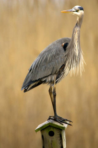
Great blue heron. USFWS
These guys are some of the easiest birds to spot in a tidal marsh. They are tall and are bluish-gray overall, and you’ll often see them wading around in the water with their long legs. Their long, spear-like bill helps them catch fish. If you are lucky enough, you may even see one of their rookeries, or breeding areas, during nesting season.
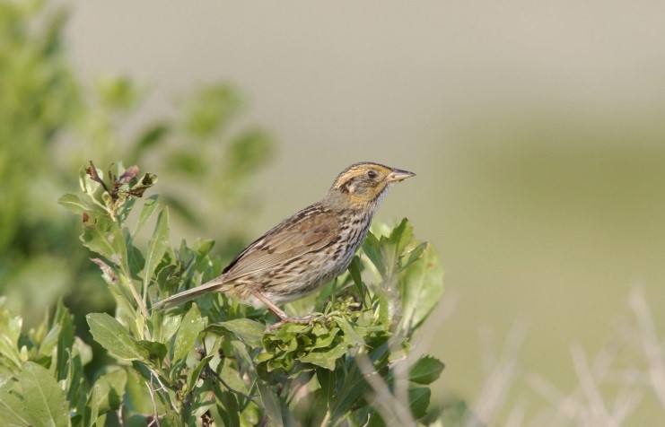
Salt marsh sparrow, National Audubon Society
These sparrows are some of the most secretive birds of the salt marshes. They are fairly small and fly low across the grasses, only to quickly disappear within them. When the males sing, their song is so quiet that it sounds almost like a whisper. They like to make their nests on the ground, often under tufts of salt meadow hay (Spartina patens), to hide them from predators. Keep your eyes peeled and your ears open and you might just be lucky enough to spot one of these secretive birds.
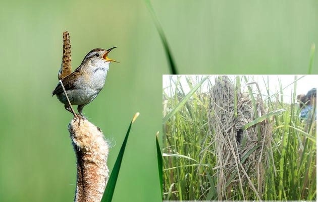
Marsh wren, National Audubon Society, Marsh wren nest, DNREC’s Wetland Monitoring & Assessment Program
You will probably hear these little birds before you see them; although they are small, they have a loud and bubbly song, and they certainly aren’t afraid to sing it! Their little brown bodies blend in with the tall grasses of brackish marshes that they like to perch on, often with each leg on two different grass blades. Their nests are off of the ground and are weaved out of grass pieces, creating a sort of elevated basket with a side entrance.
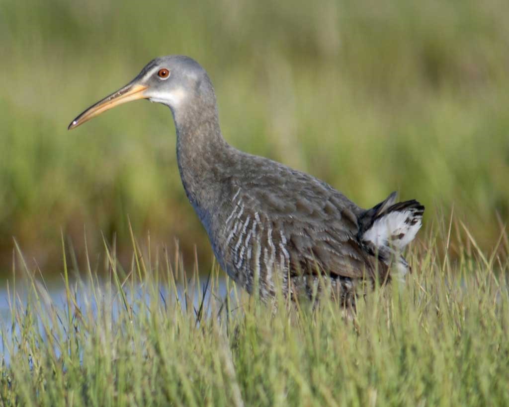
Clapper rail, National Audubon Society
Clapper rails are much larger than salt marsh sparrows, but they are still pretty secretive. Their call is a loud “kek kek”, and you’ll often hear it when planes startle them. They are often hidden in salt marsh grasses, but they do come out to muddy or shallow water areas to feed on crustaceans and small fish. They make their nests out of marsh grasses on the ground, and the nests can be tricky to find.
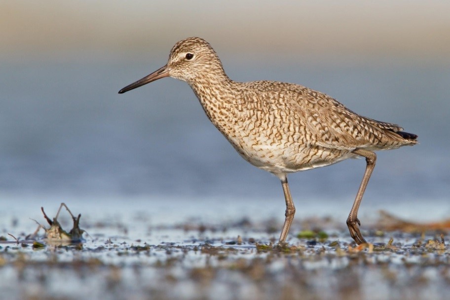
Willet, National Audubon Society
Willets are light grayish-brown birds with bright white marks on their outspread wings. They feed on insects and crustaceans in marshes, mudflats, and along beaches. They make their nests in salt marshes out of grasses, and the nests blend in very well with their surroundings. Their call is often very loud, particularly when they feel their nest is threatened.
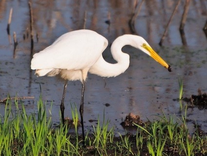
Great egret, The Cornell Lab of Ornithology
Great egrets are pretty easy to spot in marshes due to their relatively large size and their bright white color. They use their large bill to catch fish as they wade around in mud and shallow waters. Like great blue herons, they nest in colonies. You may also see snowy egrets in the marshes, which are similar in appearance. The tricks to tell them apart are that great egrets have yellow bills and black legs and feet, while snowy egrets are smaller in size, have blackish bills, and have black legs with yellow feet.

Osprey, The BBC
Osprey are birds of prey that are smaller than the bald eagle, and catch fish right out of the water with their sharp talons. They like to fly over marshes looking for fish in nearby waters, and will often hover in one spot when they think prey is near. Osprey like to nest on tops of dead trees, but they will also readily nest on man-made nesting platforms in salt marshes. Their nests are made of many sticks and are very large and visible, so keep a look out and you might find one.
As you have learned, birds that you see here, and many others, rely on salt and brackish marshes for survival. Unfortunately, many of them are facing trouble as climate change, rising sea levels, and human disturbance negatively affect their nesting and feeding wetland habitat. It’s up to people like you to spread the word to help them and their habitats!
The great news is, there are amazing online resources out there to learn more detailed information about these and other coastal marsh birds and the dangers they are facing from habitat changes. You can even become a citizen scientist and record your bird observations for scientists to use to help these birds out. Here are a few wonderful resources to learn more, have fun, and participate in marsh bird conservation:

Written on: December 12th, 2017 in Outreach
by Alison Rogerson, DNREC’s Wetland Monitoring & Assessment Program (aka Delaware Wetlands)
Curious as to what Delawareans think about wetlands? In September of this year we polled 600 Delaware residents across our three counties to find out. We wanted to see if people knew what wetlands are, their benefits, if they think they are good or bad, and where they are getting information about the environment.
Based on the results we came up with ten Delaware Wetlands New Year’s Resolutions to help guide our program into the future. Hey, the survey finding might even help inform your program’s activities too. We are excited to get started!

 Contrary to the old myth that wetlands are a wasteland 7 out of 8 people reacted positively that wetlands provide wildlife habitat.
Nearly half of survey participants said they never get outside to hike, birdwatch, hunt, fish or kayak.
An astounding number of people (85%) felt familiar with the term wetland and could provide some sort of definition!
 Talk more about a wetlands importance in improving water quality in Delaware’s creeks, rivers and bays.
3 out of 5 people in Delaware think water pollution is a somewhat or very serious problem.
Only half the residents surveyed thought it is a good thing to have a wetland near where they live. There were misconceptions that having a wetland near them would increase flooding.
4 out of 7 people don’t think a wetland exists within a mile of them. Yet 1/4 of Delaware’s land area is wetlands, so they are around every corner!
According to this survey, people are most likely to trust DNREC, the Division of Parks and Recreation, and the University of Delaware Cooperative Extension with information about the natural environment.
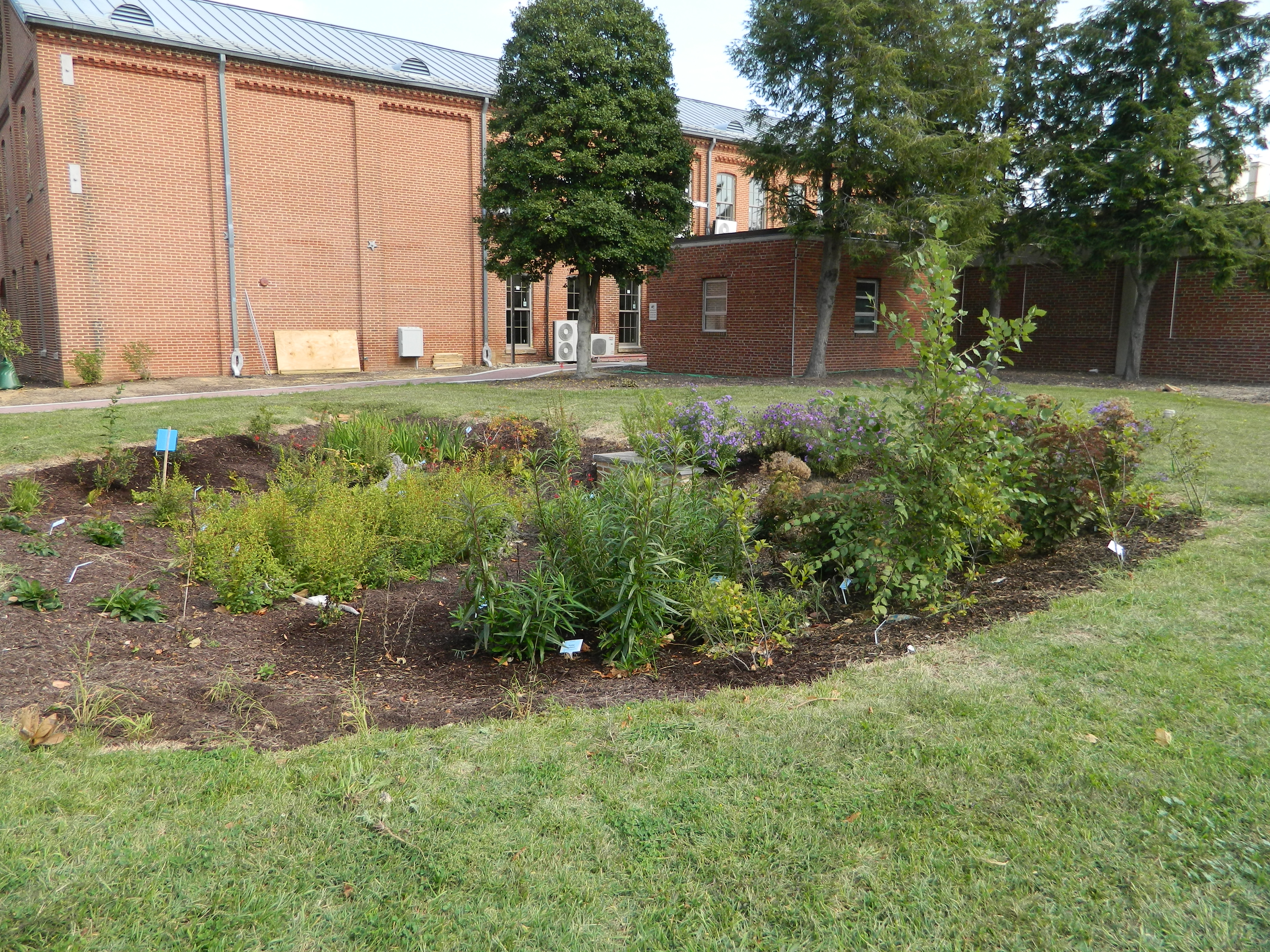
Rain garden at DNREC building in Dover
75% of survey takers live on less than an acre of land.
Polled citizens are more likely to use a website to find information than social media or printed publications (mailers or newspaper).
For more information about the Delaware Wetlands Survey please contact brittany.haywood@delaware.gov.

Written on: December 12th, 2017 in Wetland Assessments
Guest Writer: Tom McKenna, University of Delaware

Figure 1a. Spring on a perched floodplain along a tributary of White Clay Creek. a. visual image. Photo Credit: Tom McKenna, UD
Groundwater discharge areas are common hydrologic features in Delaware’s Piedmont Province, located in hilly northern New Castle County. Discharge occurs as springs or seeps. (A seep can be described as simply a spring with discharge through the very small openings between soil or sediment grains. In reality it is a continuum between the two terms). Some are subaqueous features, meaning that groundwater discharges directly to surface water, like a creek. Other seeps and springs are subaerial, so groundwater discharges to the land surface.
Subaerial discharge is often associated with seep or spring wetlands. One unique type of these is the Piedmont Stream Valley Wetlands that are habitats for rare plant species and the federally threatened bog turtle (Bill McAvoy, DNREC). In some places, the springs and seeps are also likely to be conduits for nutrients like nitrogen and phosphorous that result in creeks being “impaired water bodies” (as determined by DNREC and EPA).
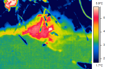
Figure 1b. A thermal image. Spring on a perched floodplain along a tributary of White Clay Creek. Temperatures are “apparent” temperatures as the radiation imaged is a function of the observation angle, reflected temperature from surrounding objects and a property of the object call the emissivity. The temperature for the water is close to the true kinetic temperature as the imager is set to image water with local reflected temperature taken into account. A small wetland (<20 m2) exists downstream of this spring.
Understanding the flow of groundwater that discharges to these creeks and wetlands is difficult because we have a poor knowledge of the distribution of rock fractures that control groundwater flow patterns. The fractured rocks are typically overlain by a 0 to 50-meter-thick regolith that hides the fractures.
One way to gain insight into these groundwater flow systems is to work backward in the groundwater flow system by first locating discharge at seeps and springs (groundwater outcrops*). To address this issue, I am identifying spring and seep locations in the White Clay Creek (Figures 1a and 1b) and other Piedmont watersheds (Figure 4) by conducting walking in-stream surveys with a thermal-imaging camera (Scientifically, it is known as a thermal imaging focal-plane radiometer).
The surveys are typically done on cold mornings in winter between 5 and 10 am. Springs are identified based on the temperature difference between water emanating from the spring (warmer in winter) and the ambient water or land surface (colder in winter). Direct measurements of temperature and specific conductivity are made and GPS coordinates are recorded.
Initial studies clearly indicate that springs are commonly found in the tributaries of White Clay Creek (e.g. higher-order streams), but are not common in the main stem of the White Clay Creek in Delaware and southern Chester County, PA.
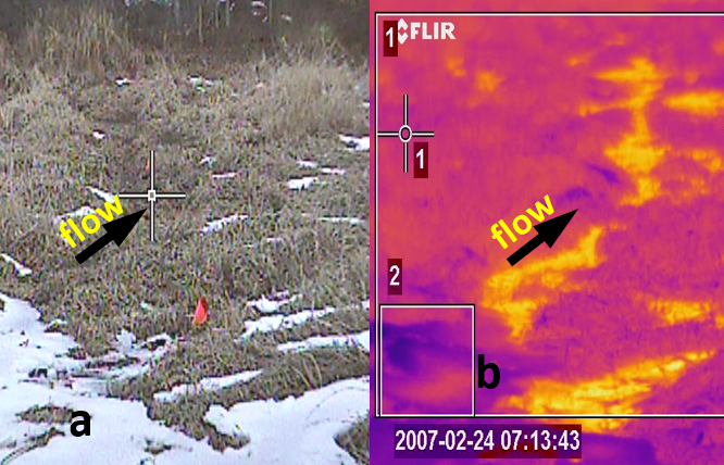
Figure 4. Freshwater Marsh, Brandywine Creek State Park on cold morning in winter This set of images shows how heat can be used as a tracer of hydrologic processes. a. visual image. Water was everywhere under the grass and flow was not visually evident. b. thermal image. Relatively warm water is flowing in very shallow channels obscured by the dense, matted vegetation. The temperature difference between dark purple and yellow colors is about 10 degrees C.
* The mapping of “groundwater outcrops” was developed in Alberta, Canada by József Tóth and Peter MeyBoom in the early 1960s (references below). The insights gained by Tóth resulted in his classic paper with illustrations published in every hydrogeology textbook. The paper also earned Tóth the highest award (Meinzer Award) given by the Hydrogeology Division of the Geological Society of America in 1963. He was the first recipient in 1965. The technique and term have fallen away in the literature but its validity still holds true.
Meyboom, P., 1966. Groundwater studies in the Assiniboine River drainage basin: Part I: The evaluation of a flow system in South Central Saskatchewan: Geol. Survey of Canada, Bull. 139, Ottawa, 65 p.
Toth, J., 1963, A theoretical analysis of groundwater flow in small drainage basins, Journal of Geophysical Research, 68(16,) 4795-4812.

Written on: December 11th, 2017 in Wetland Restorations
Guest Writer: Susan Guiteras, USFWS
If you have an interest in Delaware wetlands, chances are you’ve heard about the management challenges and subsequent tidal marsh restoration at Prime Hook NWR, near Milton. For many years, two large areas encompassing about 4000 acres of the refuge were managed as freshwater impoundments.
Beginning in 2006 a series of storms created overwashes and large breaches along the shoreline that separated the managed impoundments from the Delaware Bay, flooding them relentlessly with saltwater. Hurricane Sandy was the final blow to the system, which had suffered rapid peat collapse and widespread conversion to open water.
There were several years of careful discussions and difficult planning as the refuge worked out a long-term strategy to ultimately restore the impounded wetlands to their historic tidal marsh condition.
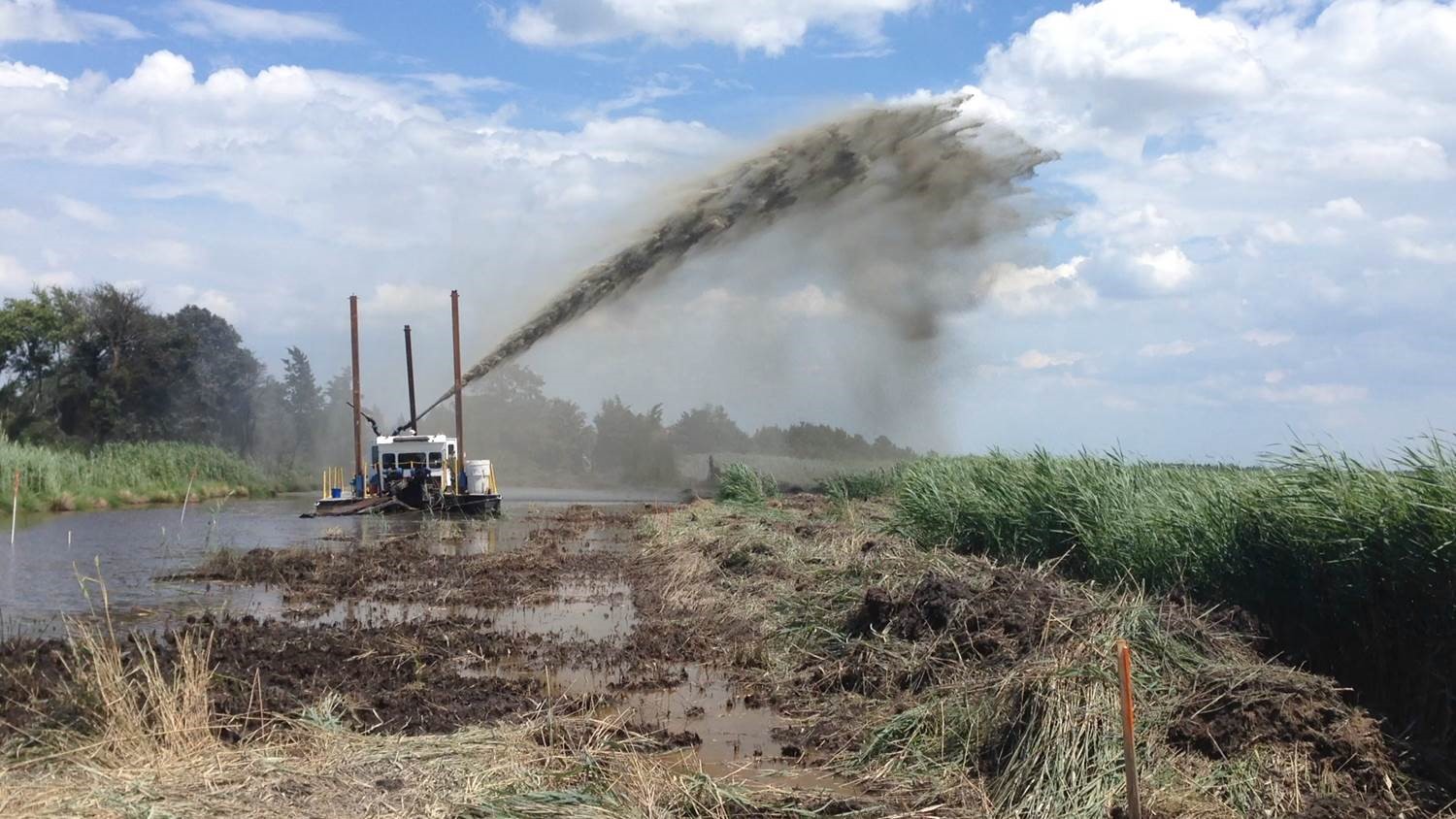
Dredges sprayed mud onto mudflat and open water at the Prime Hook National Wildlife Refuge. Photo Credit: USFWS
The restoration of the refuge wetlands was made possible by federal money through the Hurricane Sandy Disaster Relief Act, and was the largest tidal marsh restoration project ever in the east. Sand dredged from an offshore borrow area was pumped in to close the large breaches and restore the the dune, beach, and backbarrier along more than 8000 linear feet of shoreline. Nearly 60 acres in the back barrier was planted with Panicum and Spartina grasses. Within the marsh interior, more than 20 miles of tidal channels were dredged, mostly following historic drainage patterns. The dredged material was sprayed onto the adjacent area, providing on-site disposal and giving marsh elevation a boost in those areas.
The Seeds of Success program collected seeds representing a mix of 17 species suited to varying conditions, which were spread from an airplane onto large portions of the mudflats in the marsh interior to give revegetation a boost. The restoration work started in the summer of 2015 and moved at a rapid pace. Although the refuge continues to work with partners such as DelDOT and the DNREC Mosquito Control Section on small hydrological alterations in the marsh, the restoration work was largely completed by summer 2016.
As soon as the wetland management challenges began, the refuge formed a critical partnership with the DNREC and the Delaware National Estuarine Research Reserve to begin monitoring water levels and salinity throughout the system, data that was later used in hydrodynamic modeling to guide restoration planning.
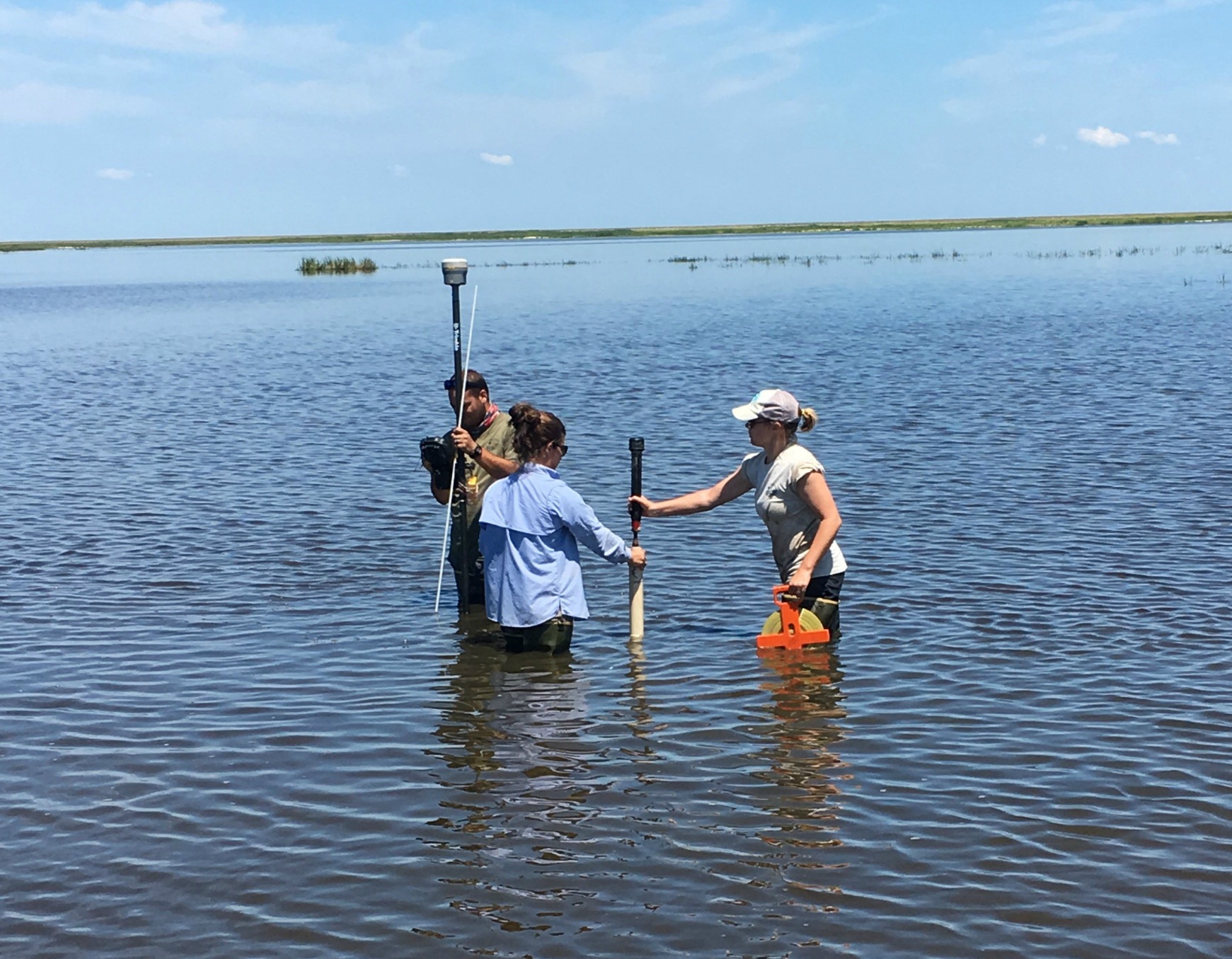
Monitoring an open water site at Prime Hook NWR with an RTK GPS, and slide hammer for soil bearing capacity. Photo credit: USFWS
As a plan for marsh restoration came together, this water monitoring network was expanded and became the basis of a comprehensive biological and abiotic restoration monitoring program. The refuge added additional partners to the effort, including the DNREC Wetland Monitoring and Assessment Program, the University of Delaware College of Earth, Ocean, and Environment, and the Saltmarsh Habitat and Avian Research Program (SHARP), also based at the University of Delaware – among others. In the years prior to, during, and immediately following restoration, these partners have worked with the refuge to collect data on everything from vegetation communities and birds to marsh elevation, sediment concentration in the water, and nutrients.
Now that the restoration has been mostly complete for more than a full growing season, some exciting recovery is evident already!
Although it may take some time for the bird and fish communities to fully respond, the newly-restored beach immediately attracted horseshoe crabs and even nesting piping plovers, least terns, and American oystercatchers. In 2015, the refuge hosted its first ever piping plover nest, and in 2016 there were 6 nests that successfully fledged 12 young birds.

Prime Hook National Wildlife Refuge marsh restoration site. Photo Credit: USFWS
However, the most dramatic evidence of restoration success so far has been the recovery of tidal marsh vegetation throughout the project area. The USFWS, SHARP team, and DNREC partners have monitored vegetation recovery with a combination of remote sensing analysis, basic ground surveys, and in-depth data collection that includes biomass and elevations. Some highlights from initial post-restoration monitoring results include…
But, it is very basic data collection – photography – that has captured the initial progress in the most compelling way. Although open water still dominates in large sections of the wetlands as marsh recovery continues, the transformation is nothing short of dramatic in many areas, as evident in the comparison photos.
What started as open water in 2015, before restoration began, was transformed into mudflats with colonizing and transitional species in 2016, which then gave way to healthy stands of saltmarsh grasses such as Spartina alterniflora in 2017. Planted areas on the backbarrier quickly filled in with lush stands of Panicum grasses and Spartina patens. The intensive monitoring of the project will continue with the refuge’s team of partners for at least the next 5 years. Stay tuned for future updates!
Delaware's Governor
State Agencies
Elected Officials
General Assembly
Delaware Courts
State Employees
Cities & Towns
Delaware State Code
State Regulations
Business First Steps
Phone Directory
Locations Directory
Public Meetings
Voting & Elections
Transparency
Delaware Marketplace
Tax Center
Personal Income Tax
Privacy Policy
Weather & Travel
Contact Us
Corporations
Franchise Tax
Gross Receipts Tax
Withholding Tax
Delaware Topics
Help Center
Mobile Apps
E-mail / Text Alerts
Social Media

Built by the Government Information Center
©MMXVIII Delaware.gov

