Facebook Twitter Instagram YouTube RSS Feed

Written on: December 12th, 2017 in Wetland Assessments
Guest Writer: Tom McKenna, University of Delaware

Figure 1a. Spring on a perched floodplain along a tributary of White Clay Creek. a. visual image. Photo Credit: Tom McKenna, UD
Groundwater discharge areas are common hydrologic features in Delaware’s Piedmont Province, located in hilly northern New Castle County. Discharge occurs as springs or seeps. (A seep can be described as simply a spring with discharge through the very small openings between soil or sediment grains. In reality it is a continuum between the two terms). Some are subaqueous features, meaning that groundwater discharges directly to surface water, like a creek. Other seeps and springs are subaerial, so groundwater discharges to the land surface.
Subaerial discharge is often associated with seep or spring wetlands. One unique type of these is the Piedmont Stream Valley Wetlands that are habitats for rare plant species and the federally threatened bog turtle (Bill McAvoy, DNREC). In some places, the springs and seeps are also likely to be conduits for nutrients like nitrogen and phosphorous that result in creeks being “impaired water bodies” (as determined by DNREC and EPA).
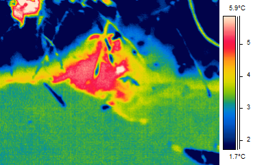
Figure 1b. A thermal image. Spring on a perched floodplain along a tributary of White Clay Creek. Temperatures are “apparent” temperatures as the radiation imaged is a function of the observation angle, reflected temperature from surrounding objects and a property of the object call the emissivity. The temperature for the water is close to the true kinetic temperature as the imager is set to image water with local reflected temperature taken into account. A small wetland (<20 m2) exists downstream of this spring.
Understanding the flow of groundwater that discharges to these creeks and wetlands is difficult because we have a poor knowledge of the distribution of rock fractures that control groundwater flow patterns. The fractured rocks are typically overlain by a 0 to 50-meter-thick regolith that hides the fractures.
One way to gain insight into these groundwater flow systems is to work backward in the groundwater flow system by first locating discharge at seeps and springs (groundwater outcrops*). To address this issue, I am identifying spring and seep locations in the White Clay Creek (Figures 1a and 1b) and other Piedmont watersheds (Figure 4) by conducting walking in-stream surveys with a thermal-imaging camera (Scientifically, it is known as a thermal imaging focal-plane radiometer).
The surveys are typically done on cold mornings in winter between 5 and 10 am. Springs are identified based on the temperature difference between water emanating from the spring (warmer in winter) and the ambient water or land surface (colder in winter). Direct measurements of temperature and specific conductivity are made and GPS coordinates are recorded.
Initial studies clearly indicate that springs are commonly found in the tributaries of White Clay Creek (e.g. higher-order streams), but are not common in the main stem of the White Clay Creek in Delaware and southern Chester County, PA.
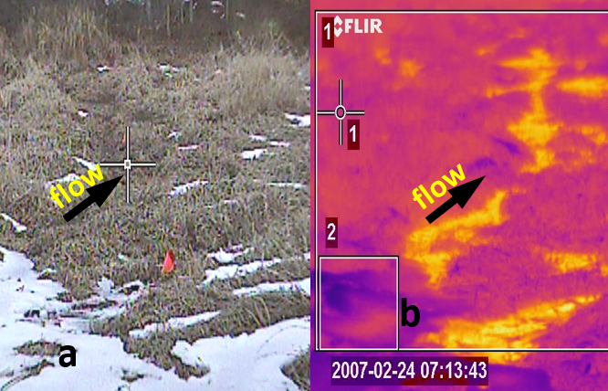
Figure 4. Freshwater Marsh, Brandywine Creek State Park on cold morning in winter This set of images shows how heat can be used as a tracer of hydrologic processes. a. visual image. Water was everywhere under the grass and flow was not visually evident. b. thermal image. Relatively warm water is flowing in very shallow channels obscured by the dense, matted vegetation. The temperature difference between dark purple and yellow colors is about 10 degrees C.
* The mapping of “groundwater outcrops” was developed in Alberta, Canada by József Tóth and Peter MeyBoom in the early 1960s (references below). The insights gained by Tóth resulted in his classic paper with illustrations published in every hydrogeology textbook. The paper also earned Tóth the highest award (Meinzer Award) given by the Hydrogeology Division of the Geological Society of America in 1963. He was the first recipient in 1965. The technique and term have fallen away in the literature but its validity still holds true.
Meyboom, P., 1966. Groundwater studies in the Assiniboine River drainage basin: Part I: The evaluation of a flow system in South Central Saskatchewan: Geol. Survey of Canada, Bull. 139, Ottawa, 65 p.
Toth, J., 1963, A theoretical analysis of groundwater flow in small drainage basins, Journal of Geophysical Research, 68(16,) 4795-4812.
Delaware's Governor
State Agencies
Elected Officials
General Assembly
Delaware Courts
State Employees
Cities & Towns
Delaware State Code
State Regulations
Business First Steps
Phone Directory
Locations Directory
Public Meetings
Voting & Elections
Transparency
Delaware Marketplace
Tax Center
Personal Income Tax
Privacy Policy
Weather & Travel
Contact Us
Corporations
Franchise Tax
Gross Receipts Tax
Withholding Tax
Delaware Topics
Help Center
Mobile Apps
E-mail / Text Alerts
Social Media

Built by the Government Information Center
©MMXVIII Delaware.gov

