Facebook Twitter Instagram YouTube

Written on: May 15th, 2020 in Education and Outreach, Wetland Restoration
By Ashley Norton and Sierra Davis, DNREC’s Shoreline and Waterway Section
The Shoreline and Waterway Section (SWMS) manages 27 channels in all 3 counties of the State of Delaware. SWMS collaborates with WMAP to find creative and beneficial ways to use sediment dredged from waterways for ecological restoration projects (as in the Piney Point Marsh Restoration/Beneficial Use project).
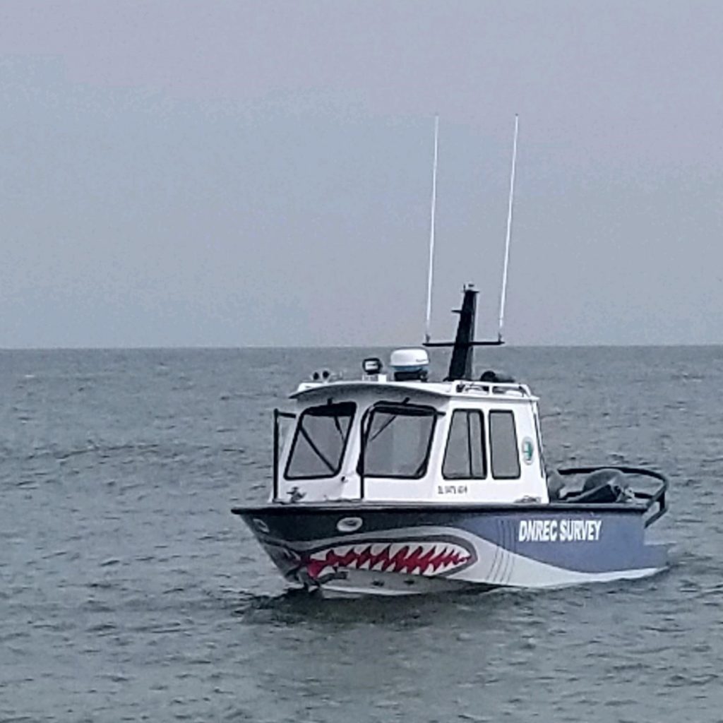
You may have seen our survey vessel and survey crew out on the water here in Delaware. This 25-foot vessel is equipped with a GPS, a sonar system to measure the depth of channels, and software used for navigation, data collection, and processing.
The sonar system on board functions like a scientific version of fish finders that you might have on your boat. The time the sound signal takes to travel from the vessel to the channel bottom and back up to the sonar’s receiver, is used to derive depth measurements. The ship’s position and motion are also incorporated and corrected for when calculating depth.
The surveys are used to determine locations to place channel markers that aid in navigation, locate and measure sediment shoals in waterways, and help with the design of dredging projects.
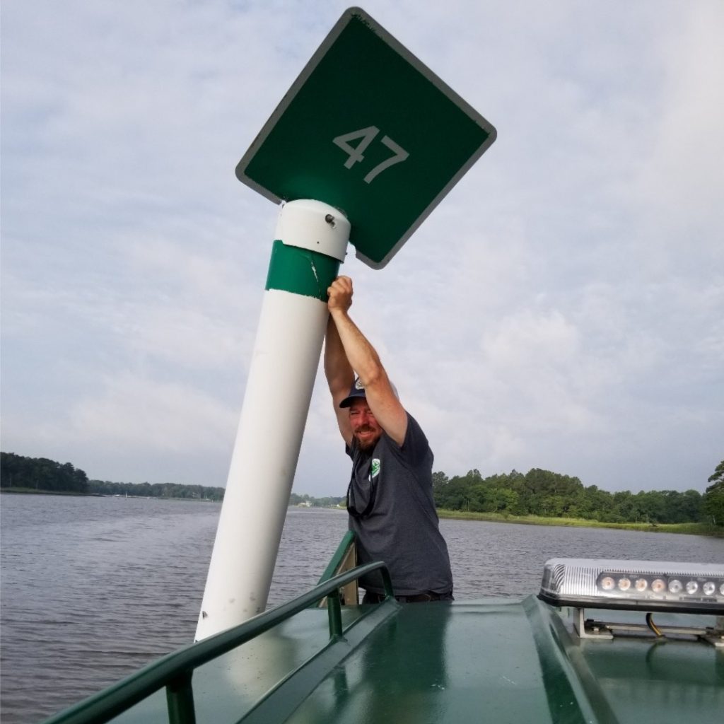
We have been marking navigational channels in Delaware’s Inland Bays since 1996. Our Section has a cooperative agreement with the United States Coast Guard to establish aids to navigation in the State’s Inland Bays channels not marked by the Coast Guard. We supplement Coast Guard markers with lighted buoys as well as PVC-pipe daybeacons.
Currently, the Section maintains almost 200 markers. Daybeacons and buoys are checked before the start of each boating season and, if needed, replaced by the Section’s channel marking crew.
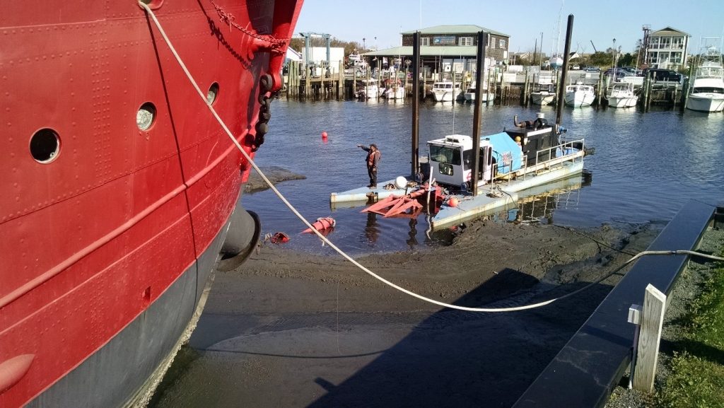
Our staff on the channel marking crew are experts in working in tidal environments and using the equipment needed to place markers. We own and maintain equipment including: vessels, a hydraulic excavator, and a sectional barge – all of which are used to place the channel markers. This typically takes a 3 to 4-person team.
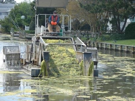
Macroalgae has become more prevalent in parts of the Inland Bays over the years as a response to increased nutrients in waterways. These nutrients come from runoff from adjacent residential and agriculture lands or domestic septic systems.
This program aims to protect, preserve, and restore natural resources in Delaware waterways by removing the excess algae growth that can become an environmental concern and cause harm.
Our Section has the capacity to operate two unique macro-algae harvesters. Harvesting helps manage large amounts of macroscopic algae located in nearshore areas. Macroscopic algae are algae you can see with the human eye, such as Ulva (or Sea lettuce).
Our Section coordinates with DNREC’s Division of Fish and Wildlife when scheduling and planning harvesting to minimize potential by-catch, such as fish, during operations.
Harvesting beneficial Submerged Aquatic Vegetation such as wigeon grass and eelgrass, is avoided because this type of growth provides good nursery habitat for aquatic species and helps to stabilize sediments.
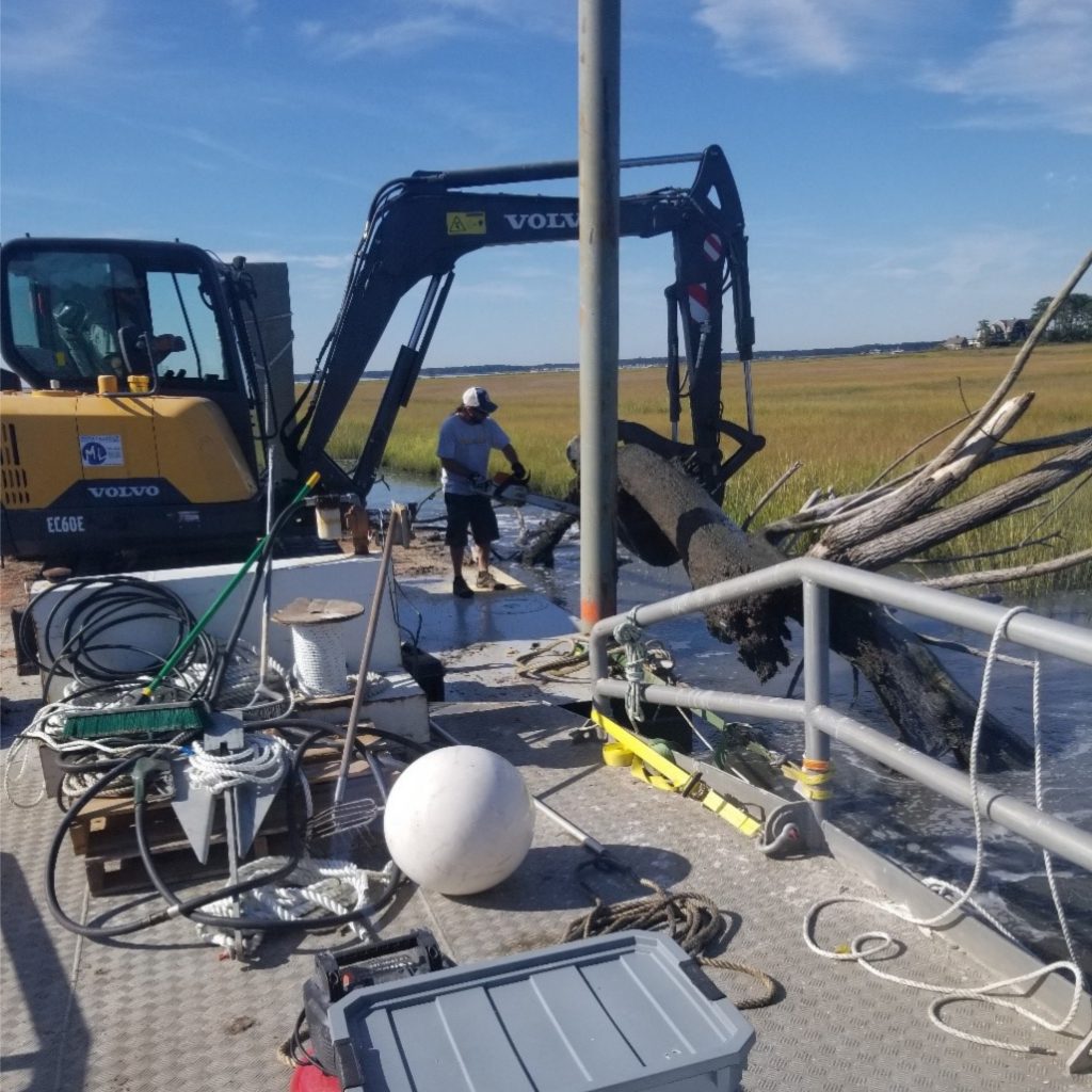
The Section owns and operates a work barge, a hydraulic excavator, and various outboard boat motors that enhance our ability to keep the state’s navigable waterways open and safe.
This equipment is used to remove abandoned vessels and derelict structures from state-maintained publicly-accessible waterways. Derelict structures might include: downed trees, ship wrecks, pilings, misplaced navigational aids, or large items of trash.
Dredging is the process of removing sediment and other material from the bottom of waterways to improve navigation. Dredging in Delaware is unique because we have a state Dredge Program that has the ability to conduct small-scale dredging operations in-house, in addition to coordinating and planning large-scale contractual operations with outside contractors.
The state currently operates two dredges that are engineered to maintain smaller waterway resources such as: channel segments, boat ramps, marinas, and state-owned lakes and ponds. In-house dredging projects include: the removal of sediment from public marina boat slips, maintaining public boat ramp depths, dredging state-owned ponds, and dredging smaller segments of channels.
Commercial dredge companies work 7 days a week around the clock and use equipment designed for removing sizeable quantities of sediment and pumping far distances for disposal. Because of this, contractual dredging is used for large-scale dredging projects in Delaware, such as the Massey’s Ditch project.
How do we decide where to dredge? We collect data and talk to our stakeholders – not only other government agencies but also the public – boaters like you! NOAA Coastal Management Fellow Sierra Davis collected a ton of data and feedback about our waterways, and has given the SWMS a way to prioritize future dredging projects. Check out her project here!
Permits are needed for dredging in Delaware. Each project must consider possible environmental effects of dredging on fisheries, water quality, and the benthic (or channel-bottom) environment.
To protect vulnerable species, dredging operations are often limited to specific months during the year. In Delaware, these environmental windows allow for dredging only in the fall and winter months. Additionally, sediment is tested before dredging begins to determine the grain size, color and presence of any contaminants to make sure that the dredging process does not stir up anything bad.
This process helps determine where sediment can be placed once dredged and that sediment can be disposed of safely. For example, if the sediment is determined to be coarse and sandy and free of contaminants, it might be beneficially used for beach nourishment.
Dredged sediment is often placed in Upland Confined Disposal Facilities (CDFs) which are diked areas of land designed to hold and safely de-water dredged sediment. The number of CDFs in Delaware has decreased over time due to facility capacity and development of upland areas as people realize the appeal of living on the water in the Inland Bays.
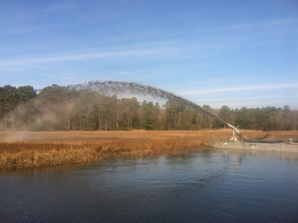
Whenever possible, it is ideal to use the sediments from a dredge project for a restoration project. Beneficial use of dredged sediment is becoming a necessary management strategy as the number of CDFs decline. Sediments themselves are also a resource and dredging practitioners such as SWMS are trying to increasingly collaborate with restoration practitioners such as WMAP to make the best use of that resource.
When dredged sediments meet certain testing standards (grain size, contaminant, color, among other testing), there can be ecological restoration opportunities that use the dredged material. These projects might include using the sediment to stabilize a shoreline, nourish a beach (such as the 2020 Massey’s Ditch project), restore an eroded marsh area, or help to protect a marsh from sea level rise (such as in the Piney Point project). With increased understanding of the environmental and restoration needs, beneficial use is regionally becoming a popular sediment management tool.
Delaware's Governor
State Agencies
Elected Officials
General Assembly
Delaware Courts
State Employees
Cities & Towns
Delaware State Code
State Regulations
Business First Steps
Phone Directory
Locations Directory
Public Meetings
Voting & Elections
Transparency
Delaware Marketplace
Tax Center
Personal Income Tax
Privacy Policy
Weather & Travel
Contact Us
Corporations
Franchise Tax
Gross Receipts Tax
Withholding Tax
Delaware Topics
Help Center
Mobile Apps
E-mail / Text Alerts
Social Media

Built by the Government Information Center
©MMXVIII Delaware.gov

