Facebook Twitter Instagram YouTube RSS Feed

Written on: May 24th, 2017 in Outreach
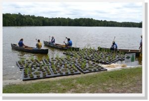
The Delaware Youth Conservation Corps preparing to install floating wetlands at Trap Pond State Park.
We’ve all heard about wetlands before but have you ever heard of a floating wetland?
Floating wetlands are artificial islands with plants on top and roots below. Similar to a natural wetland, they improve water quality by soaking up nutrients, such as nitrogen and phosphorus. These two nutrients are the primary causes of algal blooms, which make it difficult for fish and other aquatic life to survive.
Every time it rains, pollutants from lawns, roads, and other surfaces are swept into our waterways. Fortunately, we’re able to battle this runoff with floating wetlands, an efficient tool for cleaning polluted water. As the plants of the wetlands grow, they remove nutrient pollution and store it in their leaves while adding life-giving oxygen to the water. At the same time, their roots provide a home for microorganisms that feed on pollution.
The only element needed for all this to work? Simple sunlight.
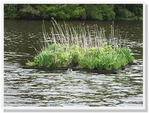
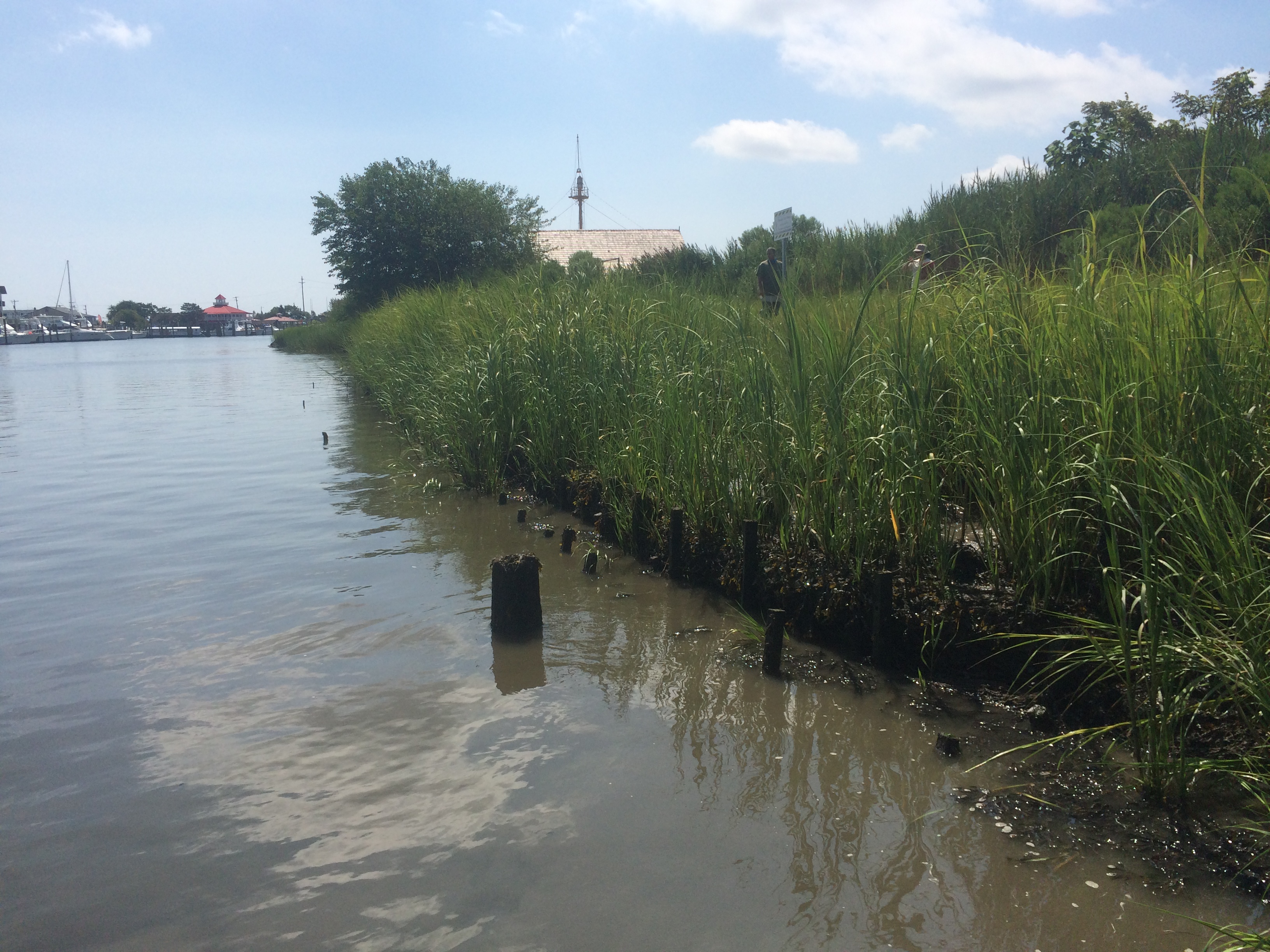
Floating wetland in the fall of season 2.
In 2015 DNREC purchased twelve floating rafts and native plants which were then linked together to form two groups of floating wetlands. The Delaware Youth Conservation Corps installed the two wetlands at Trap Pond during the Nanticoke Watershed Alliance’s annual Wade In and Nanticoke River Report Card Release event. Since then, it’s been a huge hit, not only for the students who got to install them, but also for everyone else at the park that couldn’t wait to hop in a kayak and paddle out to see them.
Over the past couple years, the wetlands have flourished and have been a destination point not only for curious paddlers but also for fisherman hoping to catch one of the many fish that find habitat in the cooler cleaner water below the raft’s root system.
Luckily, the geese have not been interested in joining in the fun. If that had occurred, there were certain plants that would have been added to deter them as well as other techniques that would have been put in place but proved not to be necessary. The turtles on the other hand, call it home –finding food and a place to sunbathe.
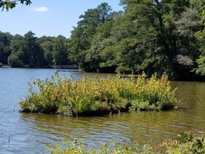
Floating wetland in the spring of season 3.
Due to the huge size of the pond, water quality improvement was not the intention of this project. This is simply a demonstration project that provides an opportunity for people to see what they are and learn about how they work.
Trap Pond is an ideal setting, not only because of the traffic through the park –the fisherman, paddlers, boaters, hikers, campers, students and anyone who passes them, but also because of the accessibility. To be able to paddle out and get a close up look at exactly how it’s working has been enjoyed and appreciated by the park’s visitors since the day they were installed. They’ve since been added as an educational component of the pontoon tours and canoe and kayak trips.
Stop by Trap Pond to see their progress this summer!

Written on: May 22nd, 2017 in Wetland Restorations
Guest Writer: Melissa Hubert, DNREC’s Drainage Program
Fun fact, did you know that there are 234 tax ditch organizations scattered across Delaware that provide water management services to over 100,000 residents and nearly half of the state-maintained roads?
These watershed based organizations are responsible for maintaining over 2,000 miles of ditch channel to ensure the drainage functionality of these systems stays running strong. This is no easy feat considering most tax ditches were constructed over 30 years ago when the landscape across Delaware looked much different. The aging infrastructure of most tax ditches in conjunction with landuse changes have resulted in major maintenance concerns that need to be addressed.

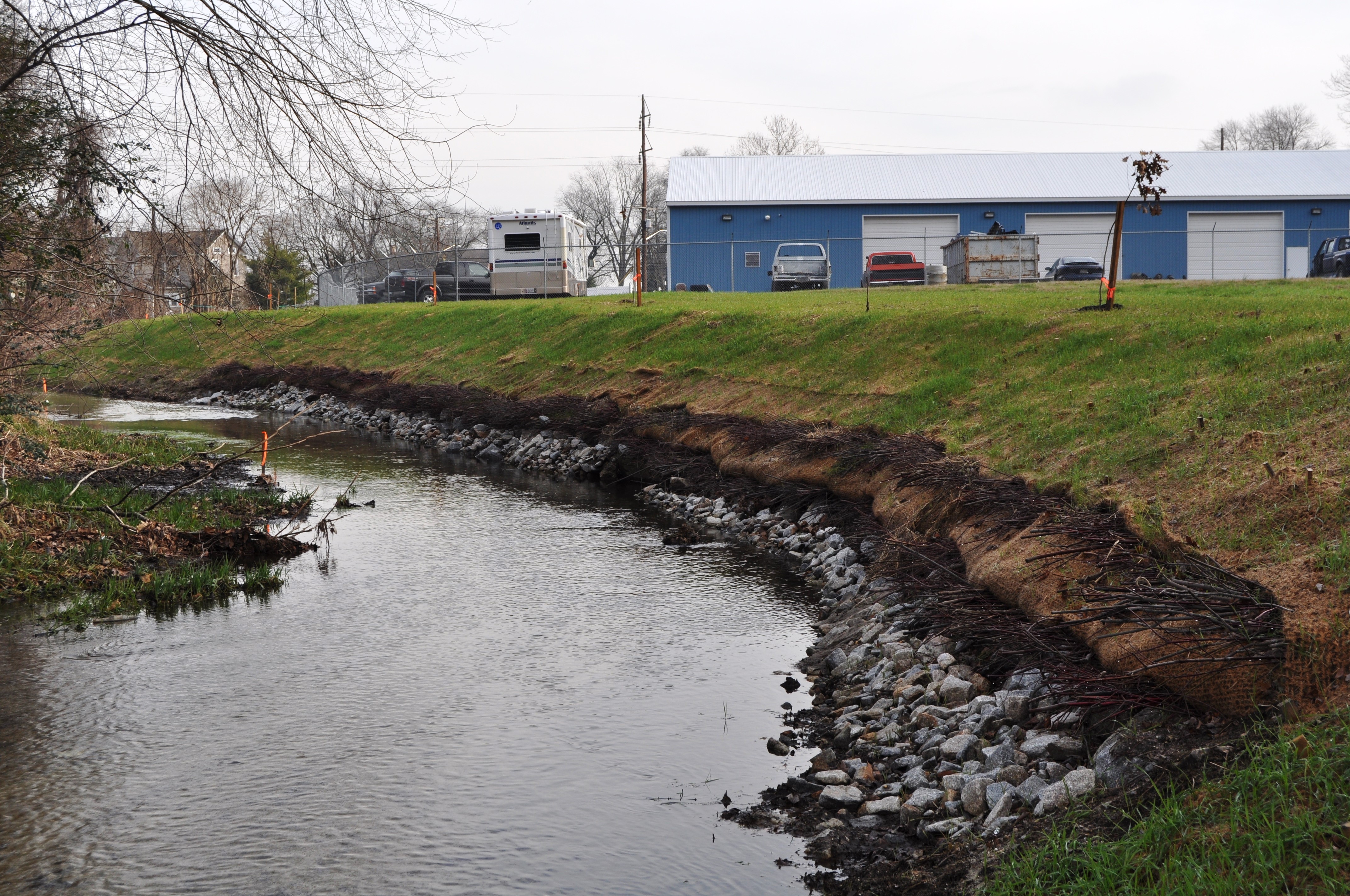
Conditions of the Bridgeville Branch Tax Ditch channel before the stream restoration project. Note the straight channel.
As these engineered systems attempt to handle stormwater flows that they were not designed for, the ditch channels often undergo changes caused by moving water that deepen and widen the channels, cause bank erosion, and create sediment bars. These side-effects change the ditch systems from their original designs which in turn, may limit their water capacity, decrease response time to storm events, and make it more difficult to perform channel maintenance.
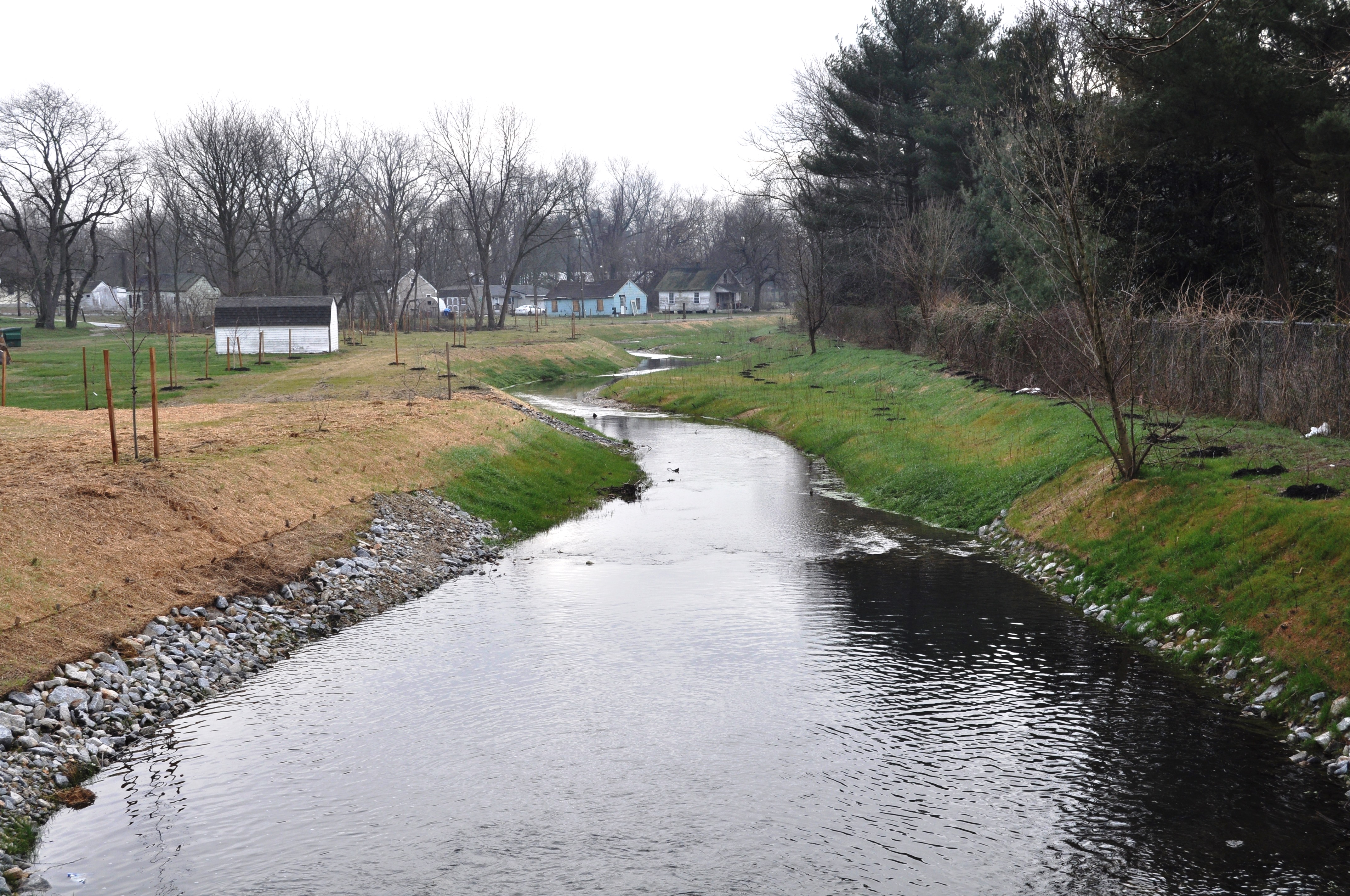
Bridgeville Branch Tax Ditch channel after the stream restoration project was completed. Note the meander of the channel, which is similar to the flow of natural streams
The DNREC Drainage Program is working with tax ditch organizations to determine ways to mimic natural in-stream processes and features with the goal of minimizing maintenance needs while still enhancing the ability of these systems to transport and clean water.
Here’s an example of one of those projects:
A portion of the Bridgeville Branch Tax Ditch, located in the Town of Bridgeville, was undercutting and widening to the point that both a sanitary sewer and water line were exposed within the channel. For a permanent solution to this serious issue, the exposed lines were properly encased and a channel that mimics a natural stream was constructed to further protect and enhance the project area.
Soil lifts with live branch cutings placed between each layer to protect this bend where the sanitary sewer line is located and improve in-stream habitat.
Natural streams transport water through the path of least resistance and as a result, many twists and turns tend to develop as water moves. For this project the ditch channel was re-aligned to establish a meandering flow path with adjacent floodplain benches to reduce the energy moving through the channel during normal and higher storm flow conditions.
In addition a stilling basin was constructed just downstream of four large pipes to slow the water when it entered the project area. A series of riffle and pool structures were created to provide flow diversity within the channel. These features not only reduce future maintenance needs, but capture and prevent pollutants from being transported further downstream, and create spawning habitat for all those critters we love.
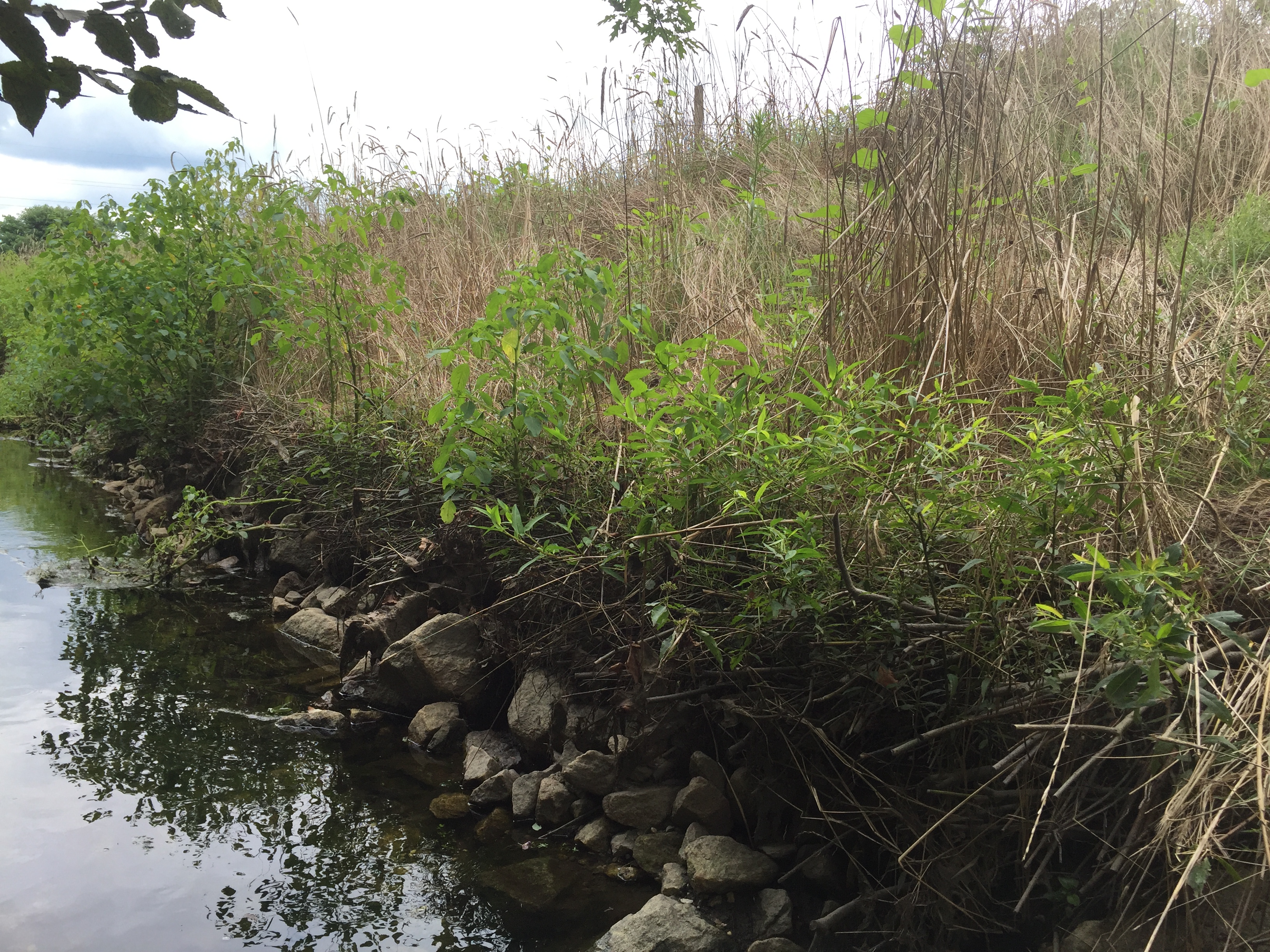
The live branch cuttings really taking off providing bank stabilization, wildlife cover, and shade for the channel.
Tree logs and root wads were pushed into the banks to provide natural protection from erosion as well as wildlife habitat and cover. Soil lifts or soils wrapped in an organic material were installed with branches placed between each lift to restore a portion of the ditch bank that was previously lost to erosion.
Last but not least the entire project area was planted with native species of riparian grasses, trees, and shrubs with live branch cuttings planted on the banks to rapidly establish stability, shade, and in-stream cover.
In this project nature was re-engineered by implementing natural design techniques and features that not only improved the functionality of the tax ditch channel and reduced future maintenance needs but also enhanced wildlife habitat and water quality.
It is the DNREC Drainage Program’s hope to help tax ditch organizations plan and construct stream restoration projects like this one to address maintenance issues in the future.
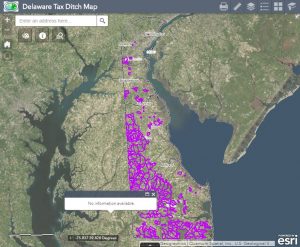
Visit this site to see where tax ditches are located near you.
Interested in getting involved? Tax ditch meetings are held annually, organized by watershed, to voice maintenance concerns and other topics. Any decisions are voted on by property owners within their own tax ditch watershed. With the prevalence of tax ditch organizations across Delaware you may even live in a watershed that has one. Check out this app to find out.

Written on: May 22nd, 2017 in Living Shorelines
Guest Writers: Julie Molina, Katie Huegel and Matt Jones of DNREC’s Wetlands & Subaqueous Lands Section
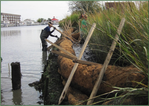
Pictured above is an armored living shoreline used in a high energy area. The project stabilized 150 linear feet of shoreline using a marsh toe sill with coir fiber logs and wetland vegetation planted behind the sill.
Delaware’s coastal communities face constant challenges from shoreline erosion. Historically, tidal wetlands act as the natural solution for shoreline stabilization. Tidal wetlands provide protection against shoreline erosion, a mechanism for flood control and natural habitat for many plant and animal species. Coastal communities today can still take advantage of having a natural means to stabilize their shorelines!
Having a natural, “living” shoreline is an increasingly popular option that provides a variety of ecological benefits while also serving a homeowner’s main goal of erosion control. For those with an interest in fishing and crabbing, the regaining of this critical riparian habitat has been proven to almost double the densities of these creatures when compared to bulkhead or riprap.
So what’s the next step?
Pictured above is a non-structural living shoreline in a low energy area. The project stabilized 84 linear feet of shoreline using coir fiber logs and wetland vegetation.
There are many different designs used when installing a living shoreline. From using coir fiber logs, to oyster castles, to a marsh toe sill with wetland plantings – the possibilities are endless. Since every shoreline is different, a site-specific design is required for successful results. Getting in contact with a consultant or contractor in order to determine which type of living shoreline would work for your property is an important next step. You can reach a consultant or contractor specializing in vegetative shoreline stabilization techniques here.
The Wetlands and Subaqueous Lands Section at DNREC has an expedited permitting process to authorize the construction of these natural living shorelines.
As long as the project meets the parameters outlined here, the Statewide Activity Approval for Shoreline Stabilization Projects can be used by coastal community residents to naturally protect their shoreline. For more information on natural living shorelines, please contact our office at (302) 739-9943.
Written on: March 16th, 2017 in Wetland Restorations
Guest Writer: Andrew Martin, Field Ecologist, Delaware Wild Lands
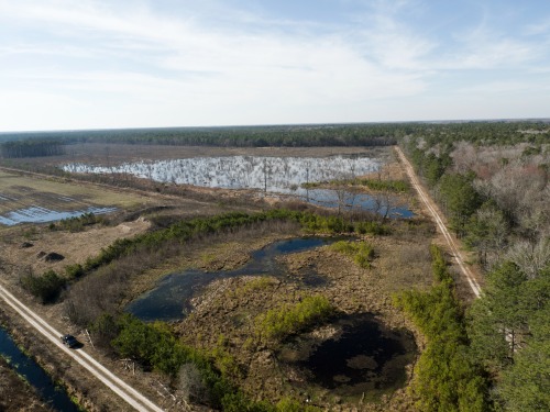
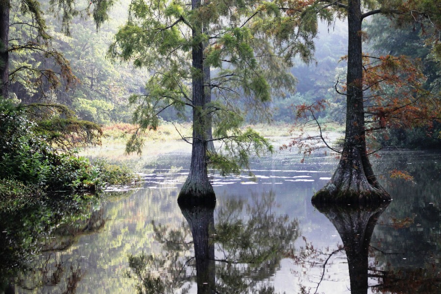
The Great Cypress Swamp once covered nearly 60,000 acres. Although a long history of ditching and draining for agriculture and development has reduced its vast expanse, the Swamp remains Delmarva Peninsula’s largest contiguous forest and largest freshwater wetland.
Freshwater wetland in Sussex County, DE. Credit: Andrew Martin, PASM Photography
For the last 50 years, Delaware Wild Lands (DWL) has been strategically purchasing and restoring this delicate ecosystem. The first parcel that DWL ever acquired was Trussom Pond in 1961. This purchase launched our efforts to protect Delaware’s iconic cypress swamp habitat. Today, DWL owns and manages more than 10,5000 contiguous acres of the Great Cypress Swamp in Sussex County and overlapping the state line into Maryland.
Trussum Pond and the 1,200 acres of unique wetlands associated with it, were handed over to the Delaware State Parks system in 1991, but our commitment to the private protection of wetlands continues. Today, as Delaware’s largest non-profit non-governmental landholder, DWL owns more than 21,000 acres throughout Delaware, and we’re actively engaged in wetland restoration in all three counties.
The Great Cypress Swamp is home to our largest and most ambitious wetland restoration work. It also contains the headwaters of the Pocomoke River, an important tributary to the Chesapeake Bay. In 2011, we installed a series of water control structures in the historic ditches, allowing us to hold back millions of gallons of water that otherwise would have drained away. In only six years, we have rehydrated hundreds, if not thousands of acres of the Swamp.
Our wetland restoration in the Great Cypress Swamp began, perhaps surprisingly, with a 150-acre timber harvest. At the time, this area was a dry woodland. Harvesting timber helped us prepare the site as we began redirecting water and creating a restored emergent wetland. The revenues from timber sales are reinvested back into restoration expenses.
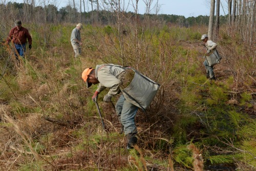
Planting seedling trees. Credit: Andrew Martin, PASM Photography
Since 2011 we’ve planted 173,000 native trees – a few thousand Baldcypress seedlings throughout, and tens of thousands of Atlantic White-cedar planted in the transitional and upland areas. Later this spring, we’re planning to plant 21,000 more trees.
As ecological systems are restored in the Swamp, a rich diversity of animal species is also returning. Each spring, hundreds of acres of newly-flooded woodlands echo with the “clack-clack-clack” of Carpenter Frogs and the mating calls of other species of frog. In some places, mature trees are dying in standing water, providing habitat for Red-headed Woodpeckers, Wood Ducks, owls, and other cavity nesters.
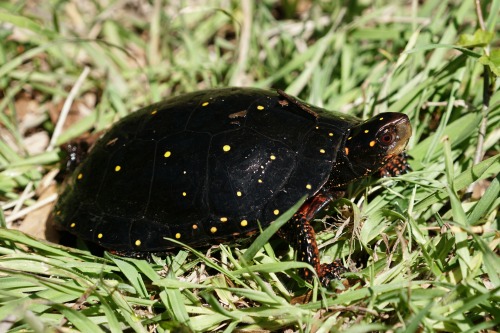
Spotted turtle. Credit: Andrew Martin, PASM Photography
Spotted Turtles – named by the Endangered Species Coalition as one of the top ten species most threatened by habitat fragmentation – now have hundreds of new acres to spread out and spawn. A new abundance of seed from wetland grasses, aquatic insects, amphibians, and even fish now provide food for wading birds like herons and egrets, and waterfowl like Mallards and Black Ducks. It is not uncommon to see dozens of Bald Eagles and other raptors soaring overhead.
Because of its delicate and sensitive nature, the Great Cypress Swamp – like all Delaware Wild Lands properties – is not open to unscheduled visitation. We do, however, offer guided tours. And the next opportunity for the public to visit the Swamp is even more fun than usual! Come join us on Saturday, May 20 for some great music at our annual Baldcypress Bluegrass Festival.
We’ll have five foot stompin’ bands playing all day from 12-6PM on a stage that backs right up to 150-year-old Baldcypress trees. Craft beers and wines will be flowing and several food trucks will be serving a delicious menu. New this year is a craft vendor area with members of the Dewey Artist Collaboration and DNREC’s Mobile Science Lab with interactive exhibits about the Chesapeake Bay Watershed.
Tickets to the festival include free bus tours through the Great Cypress Swamp that will pass right by our massive wetland restoration sites. Tickets are only $25 in advance or $35 at the gate. All proceeds benefit Delaware Wild Lands. Visit www.dewildlands.org or http://facebook.com/DelawareWildLands/events for more information and tickets.
Written on: March 15th, 2017 in Outreach
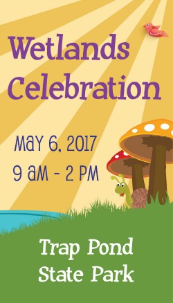 Start American Wetlands Month off right with the 14th Annual Get in Gear Family Bike Rally and the inaugural Wetlands Celebration on Saturday, May 6th from 9am to 2pm at Trap Pond State Park in Laurel, Delaware. These two events have joined together to provide fun and engaging entertainment for the whole family that brings awareness to Delmarva’s wetlands and all the critters that call them home. If your interest is in science, art, or history or you just like to be active and outside, then this event is for you.
The day kicks off with the Wetlands Celebration starting at 9 am with interactive activities, exhibitors, demos, music and live animals including horseshoe crabs, macroinvertebrates, geese, and even an opossum. Families will get the chance to take a wetland storybook walk, learn how to build a rain barrel, become a wetland scientist in the Volunteer Olympic Games, see a puppet show and more!
Multiple exhibitors will be present and include: Aquatic Resources Education Center, 3 Palms Zoo and Education Center, Ward Museum, Salisbury Zoo, Delaware Wild Lands, DNREC’s Wetland Monitoring and Assessment Program, Delaware National Estuarine Research Reserve, Delaware Division of Public Health, Nanticoke Watershed Alliance, and Trap Pond State Park.
Not to be forgotten are the free pontoon boat tours of Trap Pond that will take off every hour with the last one pulling out at 3:00pm and will give you a brief history of the pond and some of the plants and animals that call the place home. Are you the adventurous type? You can chart your own path and rent one of the park’s canoes and kayaks to go exploring on your own.
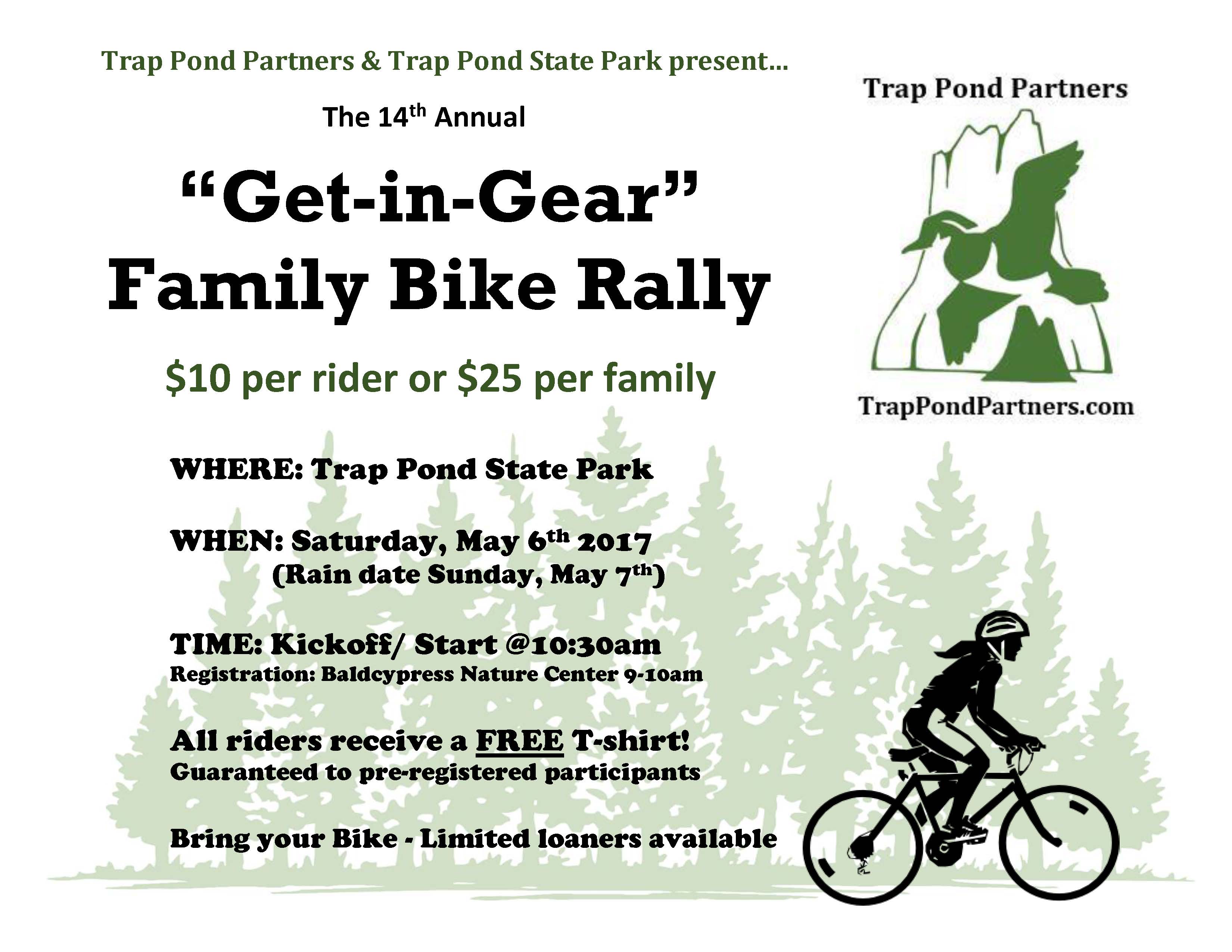 If you prefer to travel around the park by land instead of sea, join the Family Bike Rally which is run by Trap Pond Partners, starts at 10:30 am and allows you to traverse the perimeter of Trap Pond using the power of your own two feet. Registration for the Bike Rally is $10 per person or $25 per family, and it is requested that you bring your own bike. All funds go to support Trap Pond State Park. Click here to sign up or for more information about becoming a sponsor.
Worried that you will be having too much fun, but there won’t be anything to eat? You’re covered with food trucks and vendors providing breakfast, lunch and dessert from Backyard Louies, Abbotts Grille, Hotdogs from the Beach and Ritas Italian Ice.
Park admission will be covered by the Bike Rally admission fee, or by being one of the first 150 cars to mention the Wetlands Celebration day at the fee booth! While you’re at the park, don’t forget to check out the trails or the Bald Cypress Nature Center to see all that Trap Pond State Park has to offer! This outdoor event is rain or shine, but some activities are weather permitting.
The Wetlands Celebration Event is supported by DNREC’s Wetland Monitoring and Assessment Program.
Written on: March 15th, 2017 in Living Shorelines
Living Shorelines Really Do Work!
PDE and DNREC work together to install a living shoreline along the eroding marsh edge next to the ball field in Lewes in 2014.
Tidal wetlands are incredible ecosystems that protect us and our properties from storm floods, provide habitat for fish and wildlife, clean our water, and store carbon from the atmosphere. When these wetlands are in good condition, they have the ability to keep up with sea level rise, allowing them to persist as water levels increase. Unfortunately, many tidal wetlands are in danger of disappearing because they are stressed, leaving them vulnerable to erosion and sea level rise. The good news is that scientists are developing new ways to prevent that from happening.
Traditionally, “hardened” or “gray” shorelines, such as breakwaters, bulkheads, and riprap, have been built upon stretches of shoreline to protect properties from wave energy and flooding. Hardened shorelines, however, can actually harm our coastlines. Waves bounce off of these hardened structures and reflect back out toward the water causing that wave’s energy to go to another location where it can still do damage. They also disconnect tidal marsh habitat from the water, which prevents wildlife from moving between the water and the marsh.
That’s where living shorelines come in; living shorelines are considered “softer” or “greener” shoreline protection methods because they incorporate natural materials, such as coir logs and oyster shell bags. They can benefit the wetland ecosystem and maintain the connection between the water and the marsh, while still providing protection to upland areas and preventing erosion of the shoreline.
Data that was recently collected from a living shoreline in Lewes, DE shows us just how effective living shorelines can be!
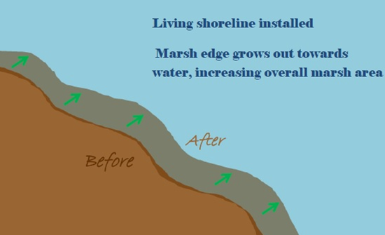
Analysis of data from a living shoreline in Lewes showed that the installation significantly extended the marsh edge towards the water. Increasing the marsh area can help stabilize eroding shorelines and help them face rising sea levels.
It was found that the Lewes living shoreline allowed the marsh edge to extend further out towards the water than it did before the installation. The project also significantly increased the height of the marsh, allowing it to support growth of smooth cordgrass (Spartina alterniflora) where it could not previously. The coir-fiber materials and shell bags that were used to construct the living shoreline did not degrade, showing that they are durable materials that can successfully be used in living shorelines projects.
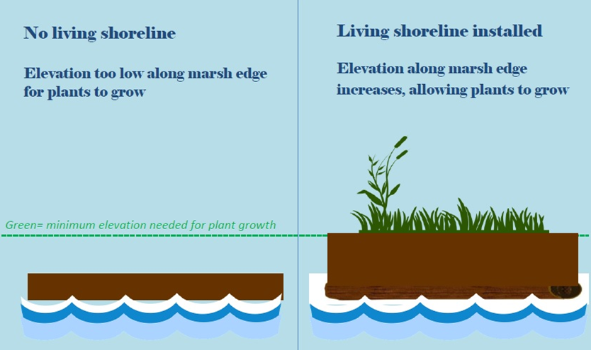
Smooth cordgrass can only grow in the marsh at a certain height above water or else it might drown. The Lewes living shoreline created a higher elevation that supported growth of smooth cordgrass.
So, what do all of these results from the Lewes living shoreline project mean? The results show us that living shorelines really are effective at increasing the stability and ecological character of marsh edges in the face of erosion and sea level rise.

Lewes living shoreline in August of 2016.
This means that they can be extremely helpful for protecting us and our properties against flooding and coastal storms, while also creating habitat for plants and wildlife! This is encouraging news that can help scientists, managers, and landowners further plan to protect our shorelines in ways that are both effective and more environmentally friendly than traditional hardened shorelines.
This project was a collaboration between our program (DNREC, Wetland Monitoring & Assessment) and the Partnership for the Delaware Estuary (PDE). To learn more about the Lewes project visit our previous blog post. Or you can dig into the data by clicking here for the full detailed report of results from the study.

Written on: March 15th, 2017 in Wetland Animals
Adult bog turtle. Credit: Amy (Alsfeld) Nazdrowicz
Guest Writer: Amy Nazdrowicz, Landmark Science & Engineering
As residents of the Delmarva Peninsula, we are blessed with a high diversity of herpetofauna, (reptiles and amphibians), in part because of our landscape position which transitions between two physiographic regions: the coastal plain in its southern and central portions to the piedmont in the north. And no place showcases our herpetological diversity as our wetlands in springtime!
Whether you reside in the piedmont or coastal plain, the wetlands of the Delmarva Peninsula are a special place in the spring when the water tables tend to be at their highest and our herp species are becoming more active.
The raucous calls of our early breeding frogs, the Spring Peeper, Wood Frog, and New Jersey Chorus Frog, are a promise of the quickly approaching spring and the much appreciated sunshine that comes along with it.
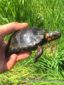
Juvenile bog turtle. Credit: Amy (Alsfeld) Nazdrowicz
But it’s a quieter harbinger that is an especially welcome sign of spring and lover of sunshine. The rare and beautiful Bog Turtle emerges along with the vegetation from a winter spent hibernating down in the muck or in subterranean tunnels surrounded by slowly flowing groundwater that provides protection from freezing. It is within a handful of our northern spring-fed wet meadows that the warm spring sunshine entices the Bog Turtle up to the surface to bask and prepare for breeding. I was once lucky enough to watch a male Bog Turtle emerge from a tunnel entrance among the roots of an Alder and blink into the sun, completely caked in mud accumulated during his winter hibernation. That was in early April but I have found Bog Turtles near the surface as early as March 20.

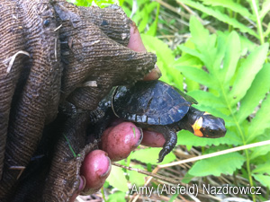
Hatchling bog turtle. Credit: Amy (Alsfeld) Nazdrowicz
The Bog Turtles’ need for plenty of sunshine continues beyond the springtime into their breeding season where mating occurs on the wetland surface from approximately mid-April through mid-June. The summer sun remains important to gravid females during gestation and they lay their eggs in peak summer atop plant tussocks to fully absorb the sunshine.
Averaging only 3-4 inches in length, an adult Bog Turtle can fit into the palm of your hand. The hatchlings, breaking out of their eggs in late summer or early fall, are no larger than the size of a quarter.
Small, dark, and masters of camouflage, the only conspicuous identifying characteristic of a Bog Turtle is a sunny splash of yellow-orange coloration on each side of the head.
As plenty of sunshine is an important habitat component, crucial Bog Turtle habitat includes open, emergent wetlands with little to no tree canopy. And, as the Bog Turtle and their habitat are federally protected under the Endangered Species Act, Bog Turtle wetlands must sometimes be actively managed to keep ecological succession at bay and to maximize the sunlight reaching the wetland surface.
After a long winter, it is safe to say that humans and Bog Turtles alike are looking forward to the return of the springtime sunshine! Happy Spring and have fun exploring the wetlands of Delmarva!
Amy (Alsfeld) Nazdrowicz is an Environmental Scientist with Landmark Science & Engineering, a civil engineering firm providing civil/site design, surveying, GIS, and environmental consulting services. As a Recognized Qualified Bog Turtle Surveyor certified in Delaware, Maryland, and Pennsylvania, Amy and her Bog Turtle team conduct Phase I, II, and III Bog Turtle Investigations, as well as radio telemetry and other Bog Turtle monitoring services, throughout the region. Amy works from Landmark’s corporate headquarters in New Castle, DE and can be reached by phone at 302-323-9377 ext. 145, or by e-mail at amyn@landmark-se.com. Visit Landmark’s website for more information and services.
Written on: March 13th, 2017 in Outreach
Bald cypress wetland. Photo by Gary Cooke
So the saying goes that no matter where you are in Delaware, you are no more than a mile away from a wetland.
But exactly where are all the wetlands in the state, and how can you find out if you have them on your property? We have just the answer for you, our new Delaware Wetland Toolbox website: de.gov/wetlandtoolbox.
This new site allows you to locate your property by inputting an address or GPS coordinates into an online mapping application. With this map, you gain access to all biological wetland locations across the state. (Heads Up: Just because a wetland is mapped does not mean it is regulated by the State. Only tidal wetlands and freshwater wetlands of 400 acres or more are regulated by the State.)
In addition to this mapping feature, you can also dig deeper into wetland knowledge by exploring the three key features to identifying wetlands, their benefits, the difference between tidal and nontidal wetlands, how you can help wetlands, and even gives you contacts for people if you have a specific question.
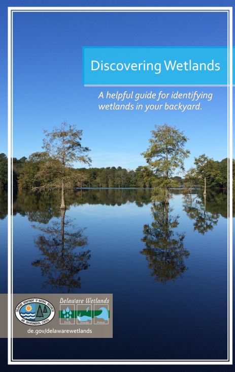
Discovering Wetlands, a helpful guide for finding wetlands on your property.
We have also rolled out a new Discovering Wetlands guide which is a handy checklist of clues for beginners that can be printed and taken with you to help identify wetlands in the field. For those of you looking to build or purchase land in the near future, it even gives you a couple of tips that are sure to make your life a little easier.
If you already know that you have wetlands on your land, and want to make a bigger commitment, we have created the Wetland Protection Promise. All you have to do is pledge to do three simple things such as disposing of trash in the proper location, volunteering at a planting or clean-up event, or to only plant native species. In return for your commitment, you will receive a free Delaware Wetlands gift. You even have the option of asking us (DNREC’s Wetland Monitoring & Assessment Program) to come to your property to give it a health check, and provide some feedback on how to improve the quality of your wetland.
We hope that these resources will help you better understand the wetlands in our State, and how they provide for us every day. We encourage you to never stop learning about the world around you!
Delaware's Governor
State Agencies
Elected Officials
General Assembly
Delaware Courts
State Employees
Cities & Towns
Delaware State Code
State Regulations
Business First Steps
Phone Directory
Locations Directory
Public Meetings
Voting & Elections
Transparency
Delaware Marketplace
Tax Center
Personal Income Tax
Privacy Policy
Weather & Travel
Contact Us
Corporations
Franchise Tax
Gross Receipts Tax
Withholding Tax
Delaware Topics
Help Center
Mobile Apps
E-mail / Text Alerts
Social Media

Built by the Government Information Center
©MMXVIII Delaware.gov

