Facebook Twitter Instagram YouTube
Written on: March 24th, 2023 in Natural Resources, Wetland Research
By Kenny Smith and Alison Rogerson, DNREC’s Wetland Monitoring and Assessment Program
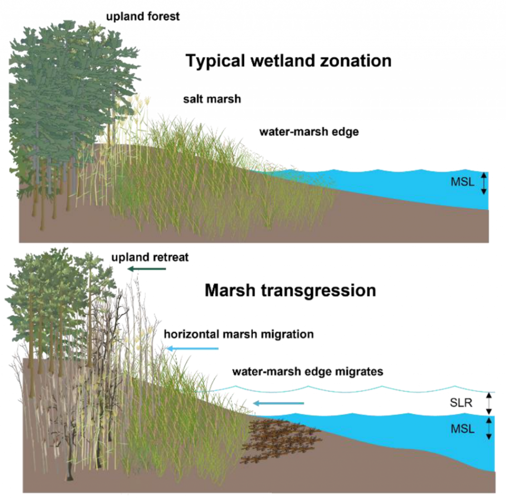
The most widely recognized migrations in the world involve animals: the red knot, monarch butterflies, salmon, wildebeest. But there is another migration happening everyday along the U.S. coastlines: marsh migration. This migration is not driven by the seasons, or daylight but is instead a response to sea level rise. Marsh migration is the act of tidal wetlands creeping slowly over time, moving away from rising sea levels towards higher, drier land to avoid drowning. Ground where the wetlands migrated from is eventually flooded and converted to open water forever.

While marsh migration is not as exciting as a stampeding herd of wildebeest in Africa or the Arctic Tern and its 40,000-mile trip spanning the length of Earth, it is a very important process happening throughout the country. Marsh migration is a natural way for wetlands to ensure their own survival into the future. Their persistence means continued benefits such as carbon storage, erosion control and storm protection. This process is not new but has become more essential as rates of sea level rise have increased in recent decades, especially in the Mid-Atlantic region. Between 2007 and 2017, Delaware lost 238.5 acres of vegetated tidal marsh, with over 66% of these losses attributed to erosion and sea level rise so it is an important topic.
As wetlands migrate, they convert the upland habitat that they move into. But not all upland areas are suitable to become tidal wetlands. How do we know where they will go in the future? How can we make sure they have room to migrate into? If coastal wetlands are so important, we should be planning ahead to ensure wetlands have a future along our coasts. Suitable migration habitat is usually shoreline that is natural and free of hardened structures that act like a barrier, have gentle slopes that allow wetlands to inch up gradually, and poorly drained soils that create wet, saturated conditions that wetlands need.
DNREC completed a mapping study in 2017 to model and predict the most suitable habitat for tidal wetlands to migrate into. This model is built from many different mapping layers including sea level rise estimates, soils, slope, land use/land cover (LULC), elevation, and existing wetlands. Model results identified 26,391 acres of highly suitable lands along existing tidal wetlands under a 4ft sea level rise scenario (Figure 2). That represents the best of all suitable habitat statewide, to narrow our focus to priority areas.

Mapping suitable habitat was step one. Diving into the results came next. Where are the best areas for wetland migration? Who owns these properties and what kind of land use are they currently in? Most importantly, what steps come next for management? For starters, 84% of the 26,391 most suitable acres were in Kent and Sussex Counties. We found that only 40% was publicly owned or otherwise protected, leaving 60% in private ownership. One third of the best migration habitat is currently in agriculture, 13% is currently forested, and 43% are already wetlands but freshwater, meaning they would undergo a major wetland change in the future. All of this is helpful as we work on the next steps which include education, outreach, messaging to landowners, and working with state and federal agencies to plan ahead.
DNREC is now refreshing this model with the most current data layers. For example the wetland, LULC, and soil layers have all been updated since 2017. Working with Delaware Coastal Programs staff, the model was rebuilt and rerun, and draft results are currently being reviewed. Look for results and a report later this year.