Delaware Wetlands logo
WMAP Blog


Facebook  Twitter  Instagram  YouTube  RSS Feed

  Archived Posts From: 2020

uncategorized

Rising to Meet the Challenge; Delaware’s Communities Start a Path Forward to Improving Resiliency

Written on: March 13th, 2020 in OutreachWetland Restorations

Guest writer: Kelly Valencik, DNREC Delaware Coastal Programs

Communities Seeing Shifts in Mother Nature

South Bethany, DE flooding during a Nor'easter in October of 2019
South Bethany, DE flooding during a Nor’easter in October of 2019

Many communities throughout our state have already seen changes as a result of climate change- from shifting rainfall and storm patterns, to increased drought, to flooding from sea level rise. These consequences of the warming earth and ocean temperatures as a result of greenhouse gas emissions have brought long term community planning challenges to Delaware.

For example, residents in the City of Lewes, which sits next to the Delaware Bay in Sussex County, have noticed more and more disruptions to the typical rhythms of nature in their community. Now it’s not just the the big coastal storms or nor’easters that cause flooding issues, it is also the sunny day, strong or spring tides that are inundating sections of main roads that connect the downtown area to the major road arteries.

Other Delaware communities have experienced similar issues and and are looking for ways to tackle these problems now before they get worse, with the ultimate goal to reduce impacts to their residents. 

The Delaware Department of Natural Resources and Environmental Control (DNREC) wants to assist municipalities and communities across the state in becoming more prepared and resilient to any change that currently appears inevitable.

What is Community Resilience?

Community resilience is the ability to plan for and bounce back quickly from hazardous events. In the coastal context, the focus is on planning for more frequent and stronger storms, sea level rise, and other changing climate conditions so that communities are better able to recover when the event occurs.

Communities and local governments in Delaware have the opportunity to be proactive and play a leading role in preparing and responding to the impacts of severe weather and climate change because municipalities largely have the responsibility for planning their own future through land use decisions, building codes and design, and maintenance of infrastructure such as water and wastewater systems. Using these tools, municipalities can be vigilant in protecting and safeguarding people and habitats from harm.

What is Green Infrastructure and how does it Affect Community Resiliency?

Green infrastructure is a nature-based approach to address environmental challenges such as stormwater runoff, coastal flooding, erosion, and water and air pollution. It uses natural processes to manage water and improve environmental quality. These natural processes include using plants and soils to:

  • filter pollutants from surface and stormwater
  • improve infiltration of water into soil and groundwater
  • reduce the volume of stormwater during high-intensity events
  • moderate air and water temperatures by shading and through evapotranspiration by plants

Stormwater and Pervious vs. Impervious Surfaces

Impervious area verses pervious area
Impervious area verses pervious area (Graphic: A Guide to the Drainage Charge)

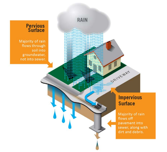
Stormwater refers to the rainwater that flows off of different surfaces after it falls to the ground. People commonly see stormwater running out of rooftop gutters and along the sides of streets during a rainstorm. The surfaces on which rainwater falls are classified into two categories:

  1. Pervious surfaces – surfaces that allow stormwater to seep into the earth like gardens, forests and grass
  2. Impervious surfaces – surfaces that don’t allow stormwater to seep into the earth like driveways, roads, sidewalks, and roof tops.

When land is developed, pervious surfaces (water infiltrating) are replaced with impervious surfaces (solid) which allows for a larger volume of stormwater to run off into storm drains and streams. This can cause more frequent flooding and can make coastal flooding or sea level rise inundation worse. In developed areas, stormwater is also more likely to pick up pollutants like gasoline residue, animal waste, and trash and carry them into streams, bays, and the ocean.

DNREC Green Infrastructure Primer for Delaware, Rain Gardens
A rain garden is a green infrastructure practice that mimics a wetland and is made from a shallow depression in the landscape with plants that allows the rainwater and stormwater to collect and infiltrate into the ground. Typically installed in community and residential areas, rain gardens are designed to hold rainwater in place, collect and filter stormwater through layers of mulch, soil, and plant root systems, and absorb and retain pollutants. (Image: DNREC Green Infrastructure Primer for Delaware)

Creating Solutions for Communities

Communities are working to improve their resiliency through the use of Best Management Practices (BMPs) to capture runoff from impervious areas, reduce flooding, and filter pollutants out of stormwater before it reaches important aquatic ecosystems, like wetlands, or recreational areas. Green infrastructure can be used in many different settings to act as a BMP that improves stormwater management and the infiltration of runoff.

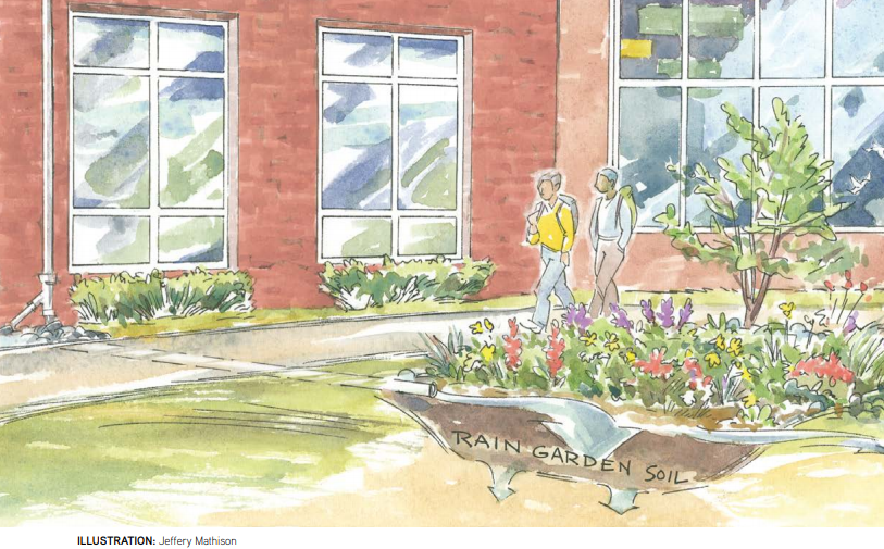
For example, trees can be used in urban, suburban, and rural settings, in plantings of one or two trees, or in a 100-foot-wide forested buffer along a river shoreline. Their root systems help absorb precipitation and filter water runoff before it reaches open bodies of water. Rain gardens can act in similar way and help manage stormwater runoff from specific areas such as roofs and parking areas, while larger expanses of conserved or restored wetlands can provide flood retention, carbon storage, and wildlife habitat.

Project in Action

Delaware Coastal Municipality Locations
Delaware Coastal Municipality Locations (First component final report)

A Community-led Focus on Stormwater Management for Improving Resiliency

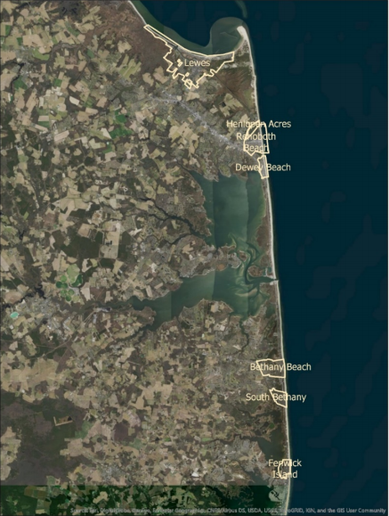
Last year the DNREC Delaware Coastal Program’s (DCP)’s Resilient Community Partnership (RCP) program worked with a group of coastal municipalities, the Cities of Lewes and Rehoboth, and the Towns of Henlopen Acres, Dewey Beach, Bethany Beach, South Bethany, and Fenwick Island, to conduct a study of impervious surface coverage. This study was done to find out what impacts the existing impervious surfaces in these cities and towns have on the stormwater management of precipitation and water quality.

These coastal communities face challenges on multiple fronts for addressing stormwater management including: tidal flooding, rapid population growth from tourism and development, a shallow groundwater table, and growing floodplain. The best path forward to consider all of these challenges to plan for their resident’s futures, was for all 7 of these communities to work together to gain an understanding of existing impervious surfaces and strategies for reducing said coverage.

Three components to this project were performed to address these multiple influences on stormwater management.

  1. First, the current (2016) and past (2007) amounts of impervious surfaces in the municipalities were determined using GIS and LiDAR with the assistance of the University of Delaware Department of Geography. This analysis included results for both private properties and municipal impervious surface areas.
  2. Second, the project contractors summarized current Best Management Practices (BMP) regarding stormwater infiltration across the state and region.
  3. Third, a final report that summarizes the Best Management Practices (BMP) for each municipality to control future impervious surfaces was created.

Many of the recommendations from this plan include methods of using green infrastructure at the municipal (or citywide level) and residential levels, and are now being considered for adoption in these communities. As a result, these communities are better prepared to react to address flooding and sea level rise concerns and have community specific nature-based solutions easily accessible to reduce the impact of impervious surfaces on their environment and water quality.

More Resources

  • The DNREC Delaware Coastal Programs office encourages stewardship of Delaware’s coastal and ocean resources by promoting informed, science-based decision making. Our office has produced tools and resources, informs local and regional planning, holds training workshops, conferences, and field demonstrations, and provides technical assistance to communities and coastal decision makers. Please visit our website for additional resources on planning and preparedness, mapping and data, and grants and funding programs.
  • Guidance on the use of Green Infrastructure is available through the DNREC Green Infrastructure Primer.
  • Additional Resilient Community Partnership project information and the full reports on the imperious surface coverage study conducted for the group of Delaware’s coastal communities can be accessed online
  • Please contact Kelly Valencik at kelly.valencik@delaware.gov for questions or additional details.

Tags: , , , , ,

wetland-assessments

LiDAR Accuracy in Delaware’s Salt Marshes

Written on: March 6th, 2020 in Wetland Assessments

Figure 1: LiDAR point cloud (left) and bare-earth DEM (right) in the St. Jones watershed

Guest Student Writer: Catherine Medlock, Graduate Student of University of Delaware

In tidal marshes, accurate representation of marsh elevation or height is critical for understanding sea-level rise, tidal inundation, and storm surge. Small changes in marsh elevation can significantly change the water movement (hydrology), plants (vegetation), and habitat. Our study aims to look at and correct a remote sensing method known as light detection and ranging (LiDAR), in order to provide accurate elevation data to scientists and coastal managers in Delaware.

What is LiDAR?

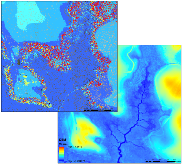
LiDAR may sound complicated, but it is really quite simple. LiDAR uses light pulses emitted from a sensor to gather 3-dimensional information about the earth’s surface. The LiDAR data is delivered as a 3-D cloud of individual points representing the ground, trees, buildings, and power lines. Ground elevation points are extracted from the point cloud, which are then used to create a digital map of the surface elevation called a digital elevation model (DEM). LiDAR is used in many coastal applications due to its high accuracy and density of data over large areas. For reference, in one square mile, LiDAR can collect over 7 million points!

LiDAR and Marshes

Figure 2: Location of study watersheds throughout Delaware

LiDAR was collected across the entire state of Delaware in early 2014. LiDAR is an incredibly useful tool for topographic mapping, flood risk management, shoreline mapping, precision agriculture, and forest planning and management. Unfortunately, in tidal marshes, the light pulses are unable to penetrate through the dense vegetation to reach the marsh surface. This results in an average overestimation of 9 to 25 cm in elevation between the DEM and the actual marsh surface, depending on the marsh vegetation. This error can in turn lead to underestimations in the extent of coastal flooding and potential marsh erosion.

Correcting LiDAR

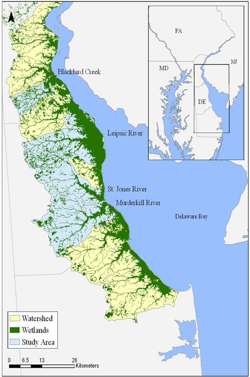
The goal of our study is to reduce the vertical error of LiDAR for mosquito ditches and the marsh platform, and provide a DEM correction that can be applied to all tidal marshes in Delaware. Four watersheds were identified to test several LiDAR correction methods: Blackbird Creek, Murderkill River, Leipsic River, and the St. Jones River. Over several years, we collected over 1000 GPS measurements with centimeter (cm)-level accuracy across the four marshes to compare DEM elevations with actual marsh elevations, and aid in the DEM corrections. As a result of the study, we plan to produce corrected DEMs, in order to model tidal inundation and assess marsh vulnerability in Delaware’s coastal marshes.

Connecting the past, present, and future

Figure 3: Murderkill River GPS surveying in February 2019 (image on left), and grid mosquito ditching in the marsh (on right: DNREC photo)

Mosquito ditches and LiDAR

Historic human activities in marshes further complicate DEM corrections. In the 1930’s, the civilian conservation corps (CCC) dug mosquito ditches across marshes in Delaware to reduce mosquito populations by draining shallow pools on the marsh surface where mosquitoes reproduce. Enhancing drainage of the marsh surface actually transformed historically low salt marsh into high salt marsh habitat. Mosquito ditches are extensive throughout Delaware, and still visible in imagery today!

Mosquito ditches have a different elevation and vegetation than the rest of the marsh, so they require their own separate DEM correction. In efforts to correct the DEM for both the marsh platform and mosquito ditches, we hope to gain a better understanding of marsh inundation and vulnerability, and provide a useful tool to aide coastal scientists and managers in preparing for future environmental changes in Delaware’s marshes.


Tags: , ,

uncategorized

Wetland Carnivorous Plants… nothing to be afraid of

Written on: March 5th, 2020 in Outreach

Little Shop of Horrors (1986) Reproduced for Educational Purposes

by Kenny Smith, DNREC Wetlands Monitoring & Assessment Program

Man-eating plants are a thing of sci-fi movies, they will send vines out to capture you or leap at you and consume you but back in the real-world carnivorous plants are a real thing.  Our world consists of more then 600 known species of carnivorous plants that use varying tactics to capture and digest their prey1. These plants mostly consume insects but on occasion can consume small mammals, amphibians, fish, and even birds if the opportunity presents itself.

Carnivorous plants use a trapping mechanism which consists of a modified leaf that draws prey into the plant. The mechanism could be in the form of a hollow leaf with liquid to passively collect and digest prey or it could be an active trap that rapidly closes its modified leaves to catch prey. The plant then relies on bacteria or enzymes to breakdown the prey into usable nitrogenous compounds and salts1.

While these plants are carnivorous most of them still create food by photosynthesis, like other plants. The meat-eating habit or adaptation supplements the diet to counteract the poor soil and environment in which they live. Most of these plants are found in wetlands or open water environments where the nutrients available are low.

Delaware’s Meat-Eating Plants

Roundleaf sundew (Drosera rotundifolia) (Photo credit: Bill McAvoy)

Delaware is home to 17 different species of carnivorous plants contained in 3 families; these are sundews, bladderworts, and pitcher plants. Of these 17 species, 4 species have not been found in Delaware for over 20 years and 6 species are considered extremely or very rare in Delaware2.  Many of these plants are in danger of being lost due to habitat loss and over-collection3.

Read below to learn a little more about these interesting and unique plants.

Sundew

There are about 152 sundew species throughout the world. Delaware is home to 4 of them, with only 2 of them found in state in the last 20 years. The Spoon-leaved Sundew (Drosera intermedia) is the most common sundew while the Roundleaf Sundew (Drosera rotundifolia) is a very rare species in Delaware2.

Spoon-leaved sundew (Drosera intermedia) (Photo credit: Bill McAvoy)

Both of these species are a perennial plant that can be found in Atlantic white cedar swamps, which are a unique wetland type in Delaware. Sundew species generally can survive better than other carnivorous plants in response to disturbance, which makes them one of the hardiest plants of the carnivorous plant group4.

Sundews have leaves covered in stalked glands that ooze sticky mucus. Sundews get their name from the sticky mucus appearing to glisten in the sun like a morning dew. After prey is trapped on the sticky hairs the edges of the leaves roll up to enclose the prey.

Bladderwort

The bladderwort genus is the most diverse and widespread of all carnivorous plants with 220 species that range from temperate to tropical habitats. Although Delaware is home to 12 bladderwort species, 4 of these species are considered extremely or very rare in our landscape. The Purple Bladderwort (Utricularia purpurea) and the Not-fused Swollen Bladderwort (Utricularia inflata) are the states rarest bladderwort species 2 .

Not-fused Swollen Bladderwort (Utricularia inflata)

Bladderworts are usually found in open water and are an aquatic perennial plant. Bladderworts use a suction type trap. They have bladders that sit under water which contain tiny hairlike projections at the opening. When a passing prey stimulates these hairs, the plant will suddenly inflate the flattened bladder which sucks the prey in, and close a trap door to prevent escape.

Very similar to most aquatic plants that live in a climate with a cold winter they have to prepare. Bladderworts do so by creating a special bud-like structure called a turion that sinks to the bottom and awaits for warmer weather. This turion contains a mass of nearly formed leaves on a stem that has not elongated yet. This mass forms and grows in response to decreasing day-length.

Pitcher-Plant

Pitcher Plants can be found throughout the world but Delaware only has one species, the Northern Purple Pitcher plant (Sarracenia purpurea)2. This species is extremely rare in Delaware and can be found in Atlantic White Cedar swamps, which also happens to be a state unique and rare wetland type.

Based off the name you could guess that this plant uses a pitcher or pitfall trap to harvest prey. This pitcher mimics flowers with its coloring and puts off decaying smells of previous victims to attract flies and other insects looking for food. Once the prey enters the pitcher, they are met with a waxy surface leading to a pool of water. To prevent the insect from simply flying away, the plant supplies a wetting agent that sticks to the insect’s wings keeping it grounded3.

Northern Purple Pitcher Plant (Sarracenia purpurea) (Photo Credit: Bill McAvoy)

Once the meal is trapped, the pitcher plant has a couple of mechanisms to digest their food:

  1. The first, is a pool of water at the bottom of the pitcher. It has a low pH of 2.0 which slowly starts to breakdown tissues when the prey is trapped3.
  2. Second, the plant secretes a sweet-nectar like substance to attract ants. It is located along the outside edge of the leaf leading into the pitcher. As ants get close, fall in and decay, they release formic acid.  This formic acid lowers the pH to 2.03, which speeds up the digestion process3.
  3. Lastly, bacteria that lives within the plant, also aide in digestion of the prey as well. This symbiosis between plant and bacteria allows the pitcher plant to focus its energy on luring insects instead of digestion.

While the plant relies on prey falling into the leaves and decaying, many animals use the pitcher plant to fulfill a life cycle phase, like the larval stage of mosquitoes, or some frogs have been found to sit in the pitchers and consume the insects that the plant attracts.

While these are examples of carnivorous plants found in Delaware there are still many other plants that consume prey, like the Venus Fly Trap found in the Carolinas or the many pitcher plants found throughout the world’s tropical forests.

Resources

1The Editors of Encyclopedia Britannica.  “Carnivorous Plant” Encyclopedia Britannica, Encyclopedia Brittannica Inc., 18 Oct 2017, https://www.britannica.com/plant/carnivorous-plant

2McAvoy, W.A. and Bennett, K.A. The Flora of Delaware: An Annotated Checklist. Delaware Department of Natural Resources and Environmental Control, 2001

3 Carnivorous Plants/Insectivorous Plants.” Carnivorous and Insectivorous Plants Online, Drosera (Sundew), Utricularia (Bladderworts), and Sarracenia (Pitcher Plants).  Botanical Society of America, https://botany.org/Carnivorous_Plants/

4Drosera Rotundifolia, Fire Effects Information System (FEIS), United States Forest Service, https://www.fs.fed.us/database/feis/plants/forb/drorot/all.html


Tags: , , , , , ,

living-shorelines

Rising Seas in the Mid-Atlantic

Written on: March 5th, 2020 in Living ShorelinesOutreachWetland Restorations

by Erin Dorset, DNREC Wetlands Monitoring & Assessment Program

Current high water conditions (mean higher high water, MHHW) and 1 and 2ft sea level rise (SLR) projections for a salt marsh in Delaware. Notice that most of the marsh is projected to be submerged with 1ft of sea level rise.

If you’re in the world of wetlands, sea level rise is a common topic of conversation. For example, here on our blog, we’ve talked about long-term monitoring efforts relating to marsh resilience in the face of rising seas and about saltwater intrusion into forested freshwater wetlands. We’ve also had a contributing author discuss effects of rising seas on trees near tidal marshes. However, sometimes we forget to stop and think about the reasons why we are experiencing sea level rise. So, let’s back up a little bit.

Why is the Mid-Atlantic a hotspot for sea level rise, and what does that mean for our coastal wetlands?

A Global Problem, A Mid-Atlantic Crisis

Sea level rise largely began with global warming, or an increase in Earth’s global temperatures. Global warming is caused by greenhouse gases absorbing and trapping solar radiation, which warms the planet more rapidly than would occur naturally. As global temperatures have risen, massive ice sheets and glaciers in Greenland and Antarctica have begun to melt rapidly, increasing sea levels. Plus, as ocean waters get warmer, they expand, further raising water levels on a global scale.

Although it is happening around the world, there are some spots that are being affected more than others. The Mid-Atlantic Coast—including Delaware—is experiencing one of the highest rates of sea level rise in the U.S, second only to the Gulf Coast.

A diagram showing the process of glacial isostatic adjustment.

Thousands of years ago, when glaciers covered much of North America, land that was just outside of the glacial footprint—such as the Mid-Atlantic region—was forced upward as the glaciers pressed down on the land they resided upon. Once the glaciers were gone, pressure was lifted, and the land that had been forced up began to slowly sink down again. That process, called glacial isostatic adjustment, is still happening in the Mid-Atlantic today. As the land sinks, or subsides, sea levels rise even more.

Worries and Hopes for Coastal Wetlands

A. gradual slope with natural lands behind allowing wetlands to move or migrate inland, B. a slope with “nick point” such as roads, development or bulkheads that prevent a wetland from moving or migrating inland (Source: Texas A&M AgriLife Extension, Climate Change Impacts on Tidal Wetlands)

Tidal wetlands have the amazing ability to gain elevation (or height) in nature. When marsh plants die, they pile up on the marsh surface and decompose slowly, while live plants help trap and keep sediments in place and out of the water. Unfortunately, sea levels are rising too quickly in the Mid-Atlantic for many wetlands to keep up. This can result in a couple of different scenarios:

  1. In some cases, marshes are lucky and have a gradual slope and natural land behind them. They can move or migrate inland as water levels climb, converting forests to wetlands as they go. 
  2. Many marshes are not so lucky, though, as roads and development often prevent them from migrating inland. Tidal wetlands will eventually drown if they are unable to move or migrate and if sea levels continue to rise. This is a huge deal, because if coastal wetlands are lost, so are their important functions, including protection from coastal storms and flooding, providing wildlife habitat, filtering pollutants, and carbon storage.

Science Lending a Helping Hand

As bleak as this outlook may sound, there is hope, too. As previously mentioned, some Mid-Atlantic wetlands might be able to keep up with sea level rise by naturally gaining enough height or elevation, while others may be able to migrate inland. In places where that is not the case, scientists and land managers are looking into other ways to save or restore tidal wetlands wherever possible and make them more hardy in the face of sea level rise. A couple of these projects include:

Beneficial use of dredge material to increase elevation of a degraded marsh in the Piney Point Tract of Assawoman Wildlife Area in Delaware.

Beneficial use of dredge material

This strategy involves using dredge material to increase elevation of struggling tidal marshes to an elevation that is optimal for plant growth, which makes them more stable. Beneficial use can also be used to rebuild marshes that have been lost completely from erosion and sea level rise. See a Delaware example!

Living shorelines

Tidal shorelines that are suffering from erosion can become stronger by using nature-based materials, such as coir logs, coir matting, and oyster shells. Look at one of the latest Delaware examples!

By incorporating the latest sea level rise projections for the Mid-Atlantic into these kinds of projects, professionals can help put our best foot forward to help coastal wetlands in our region.


Tags: , , ,
+