Facebook Twitter Instagram YouTube

Written on: September 16th, 2019 in Living Shorelines
By Chris Pfeifer, Cardno
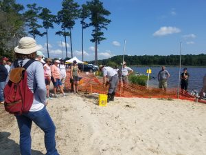
On a warm July morning not long after the official start of summer, some 2 dozen volunteers gathered at Sassafras Landing, an unimproved boat launch popular with kayakers and duck hunters inside the Delaware Division of Fish and Wildlife’s Assawoman Wildlife Area (AWA) near Frankford. Their mission: transplant nearly 5,200 plugs of native marsh grass onto what otherwise appeared to be a pristine white sand beach. The efforts that day were the final phase in constructing a living shoreline, and the culmination of more than a year’s worth of planning and design by a multidisciplinary team of scientists and engineers from the Delaware Department of Natural Resources and Environmental Control (DNREC), the Delaware Center for the Inland Bays, and Cardno, a local consulting firm.
Nearly a year before, members of the design team waded along this very shoreline. What they encountered, unfortunately, was all too common in Delaware’s Inland Bays. Along most of the shoreline, ragged undercut banks choked with Phragmites were all that remained of the fringing salt marsh that once occupied the transition zone where land meets water.
Over time, most of the Spartina alterniflora, the dominant plant species of Delaware intertidal salt marshes, had been whittled away by erosion. Analysis of aerial photos confirmed the loss of about 11 feet of fringe marsh from this shoreline between 1992 and 2017. That’s about a ½ foot per year on average. It may not sound like a lot, but inches add up over time.
Salt marshes play an important role in combating shoreline erosion and protecting adjoining uplands. The leaves and stems of marsh grasses absorb and dissipate wave energy, while the dense, intertwining roots help bind the soil. Although marsh loss due to erosion is never a good thing, wider marshes can withstand the damage without sacrificing too much of their protective function. But narrower marshes, like at Sassafras Landing, are less able to sustain the loss. And in some places, the stakes are higher than others.
Such is the case at Sassafras Landing where the ever-narrowing marsh fringe helps protect and maintain an important feature just landward of water’s edge: a low berm of mounded soil constructed decades ago to separate the tidal waters of Miller Creek from 35 Acre Pond, one of five non-tidal freshwater impoundments within AWA managed for wildlife and ecological diversity. In the narrowest part of the berm, hastily piled rocks line an indentation in the shoreline; a stop-gap to repair erosion from a coastal storm that almost breached the berm several years ago and an ever-present reminder of the ongoing threat from shoreline erosion.
It was clear to the team that something was needed to address the shoreline erosion, but what? As a partner in a statewide initiative to increase awareness of alternatives to traditional “hard armoring” practices like riprap and bulkhead, the Delaware Center for the Inland Bays selected Sassafras Landing as a living shoreline demonstration project.
The term “living shoreline” refers to a suite of shoreline stabilization and erosion control techniques that use natural materials like wetland plants, oyster shells, and coconut fiber “biologs” to repair damaged shorelines and increase their resiliency to the adverse effects of erosion and sea level rise. Sometimes more structural components like rock are used in combination in what’s known as an “armored living shoreline.” Regardless of these variations, all living shorelines seek to sustain, enhance or restore ecological functions and maintain or reestablish connections between uplands and aquatic habitats across their natural gradients.
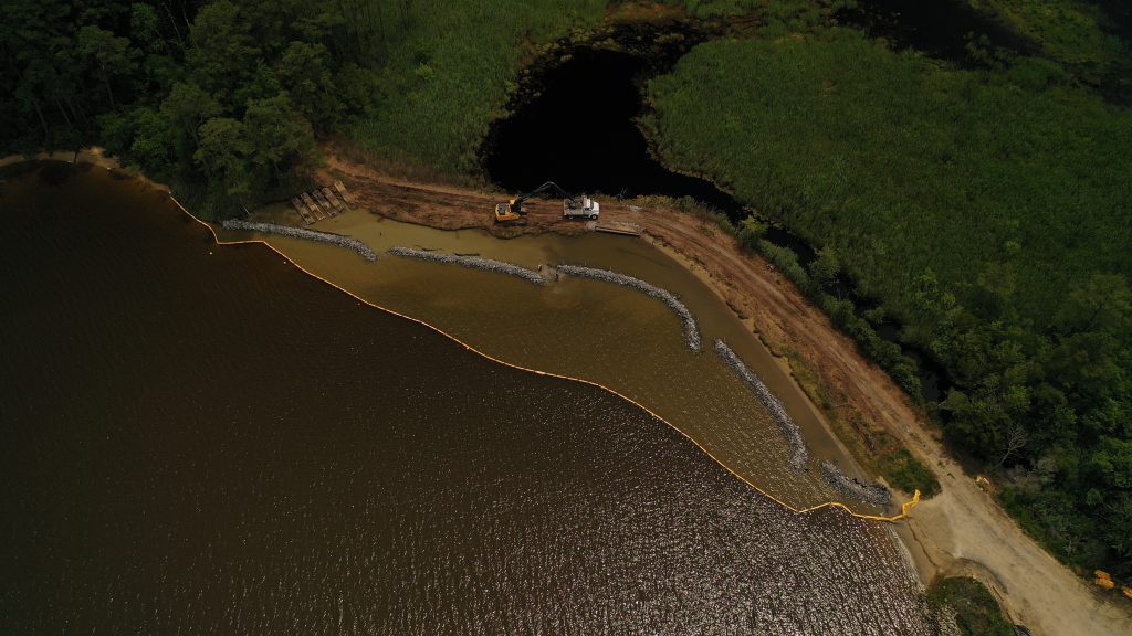
After evaluating several different living shoreline techniques in relation to site conditions and project goals, the design team selected an armored living shoreline treatment known as a rock toe sill. This treatment consists of a linear arrangement of free-standing rocks (the “sill”) just offshore parallel to the eroding shoreline. The area between the toe sill and the shoreline is then backfilled with clean sand, graded to appropriate elevations, and planted with native vegetation to create or restore a protective marsh fringe.
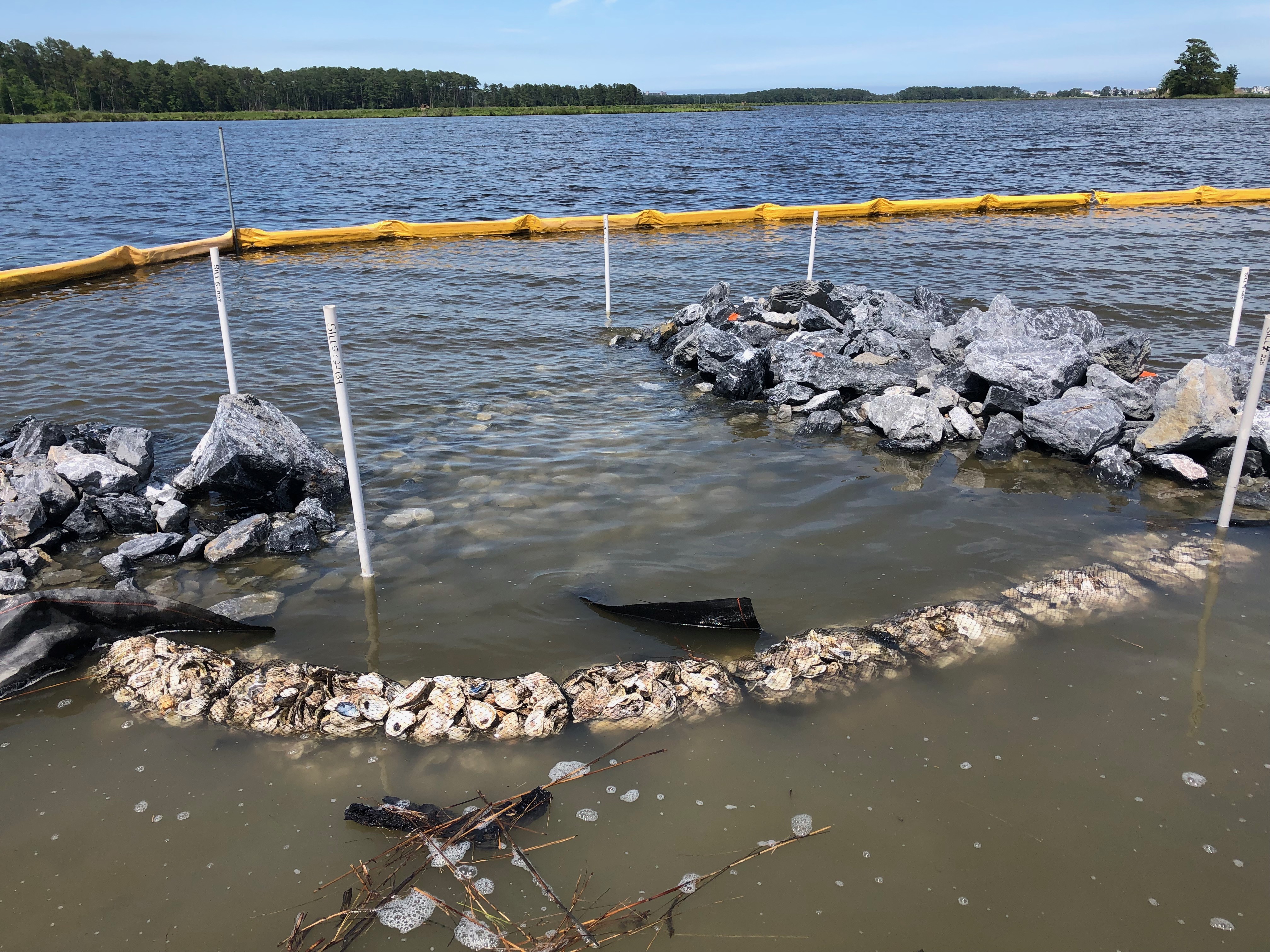
Information about parameters like shoreline orientation, topography, fetch, tides, wave energy, and water depths were gathered through a site evaluation process and then used to refine the conceptual design. After several iterations, the design was finalized. It included 5 segments of low-profile rock toe sill spanning just over 400 linear feet. Taking sea level rise into consideration, each sill is between 7-8 feet wide at its base and 2-3 feet tall, putting the top of each sill 6 inches above the average water level at high tide. Since only the highest high tides will overtop the sill, 5-foot gaps were included between each segment to allow for tidal exchange and passage of aquatic organisms. The western ends of all but one sill flare outward to shield the gaps from exposure to the northeast, the direction of the most powerful storm-driven wind and waves, and the longest fetch. As added protection, mesh bags containing oyster shells line the inside of each opening to help absorb wave energy and retain fill.
Once the design was finalized, permit applications were submitted to DNREC’s Wetlands and Subaqueous Lands Section and the U.S. Army Corps of Engineers. Due to the amount of fill required, the project did not qualify for DNREC’s Statewide Activity Approval for living shorelines, and instead received an individual subaqueous lands permit. Authorization from the Army Corps was granted under Nationwide Permit 27 for Aquatic Habitat Restoration, Enhancement, and Establishment Activities.
Funding for project construction was received through the 319 Nonpoint Source Program Grant and in-kind contributions from several of the groups involved. Construction of the toe sill, backfilling, and grading were all performed in-house by the Division of Fish & Wildlife’s Little Creek construction crew. Staff from AWA, Cardno, and Delaware Center for the Inland Bays oversaw the construction activities.
Earthwork was initiated in early June and was completed over the next four weeks. Which brings us back to where we started. As the final step, nearly 5,200 plugs of three different species were planted in zones according to their hydrologic preference. Spartina alterniflora, known commonly as smooth cordgrass, was planted at the lowest elevation. Spartina patens (saltmarsh hay) followed higher on the shoreline, above the level of daily tidal inundation. Switchgrass (Panicum virgatum) was mixed in at the highest elevation where the new shoreline meets the berm.
Just two short months after completion, the Sassafras Landing living shoreline is indeed coming alive. Aside from a few dead or missing plugs, which is to be expected, the planted grasses are thriving. Although individual plugs are still recognizable up close, even from a short distance away, the shoreline is beginning to take on a more and more natural appearance.
Schools of small fish abound in the quiescent water landward of the sill along with a handful of blue crabs. Though the new living shoreline has yet to be tested by tropical storm or nor’easter, we remain ever hopeful that the efforts of this spring and summer, and the planning and design that preceded construction, are the beginning of a new chapter for this little piece of shoreline and the valuable habitat it protects.
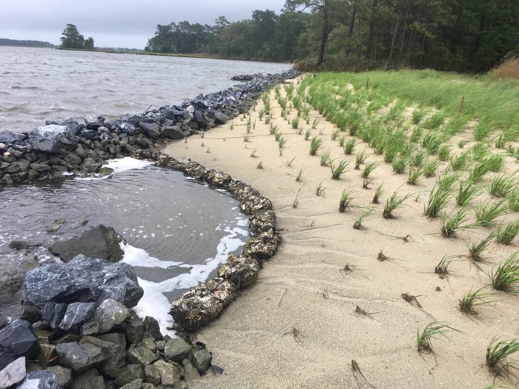
The completed Sassafras Landing living shoreline project after Hurricane Dorian passed and brought high water levels in August of 2019.
Delaware's Governor
State Agencies
Elected Officials
General Assembly
Delaware Courts
State Employees
Cities & Towns
Delaware State Code
State Regulations
Business First Steps
Phone Directory
Locations Directory
Public Meetings
Voting & Elections
Transparency
Delaware Marketplace
Tax Center
Personal Income Tax
Privacy Policy
Weather & Travel
Contact Us
Corporations
Franchise Tax
Gross Receipts Tax
Withholding Tax
Delaware Topics
Help Center
Mobile Apps
E-mail / Text Alerts
Social Media

Built by the Government Information Center
©MMXVIII Delaware.gov

