Facebook Twitter Instagram YouTube RSS Feed

Written on: December 9th, 2020 in Living Shorelines
By Kenny Smith, Wetland Monitoring & Assessment Program
The Delaware Living Shorelines Committee members are often asked questions by landowners. Many of those questions relate to the suitability of their property for a living shorelines project. For example: is it possible to build a living shoreline on their property? Can a living shoreline protect their property from coastal erosion or create more beneficial habitat for wildlife?
The Delaware Living Shoreline Committee has a smaller sub-committee, the Design and Engineering Sub-Committee, that decided to tackle these questions. They created a document that informs professionals and landowners about the feasibility of a living shoreline for a property. This document is called Site Evaluation for Living Shoreline Projects in Delaware.
The Design and Engineering Sub-Committee consists of individuals from a wide variety of backgrounds, from government employees to private contractors, that are installing living shorelines in Delaware. This diverse group provided the necessary expertise to digest a lot of information into an easy-to-follow document. The guidance highlights important metrics to look at on a shoreline. The document is separated into a desktop analysis and a field visit portion. In total, there are 12 metrics to calculate during the desktop analysis and 5 additional metrics to collect during the field visit.
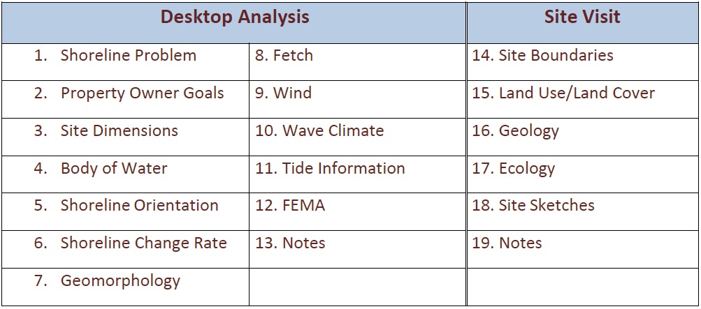
Metrics in the site evaluation document.
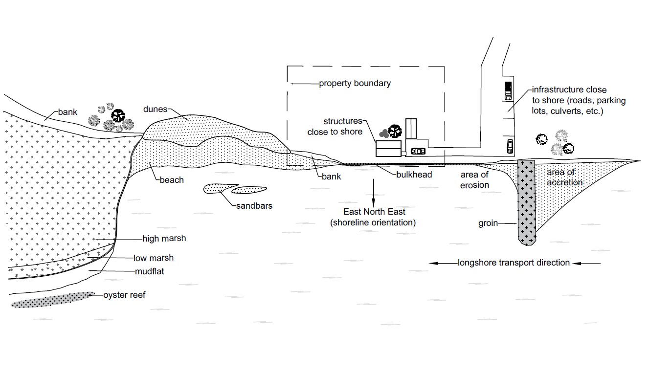
The desktop analysis portion of site evaluation document explains important environmental parameters that must be calculated to determine the feasibility of a site for a living shoreline. You can calculate these parameters using desktop tools and resources. The list of parameters starts with descriptions of the site, shoreline problem, project goals, dimensions, and body of water. While these descriptor metrics are very basic, they are the basis for all future plans for the site.

Fetch calculation for a potential living shoreline design.
The next step is to collect metrics that will steer design plans and feed into calculating some of the more complex metrics. These metrics include shoreline orientation and shoreline change rate. They also include geomorphology of the site, such as upland, shore, and submerged areas. This information is important in classifying current conditions at the site and determining what kind of techniques would be suitable. You will then use the fetch (distance over which wind blows on the water surface to generate waves) and wind metrics to calculate wave climate. From there you can determine expected energy.
The tide metric will provide you with an idea of the range of water your site receives. It will also provide a working window once your project is designed. Delaware has the FEMA maps available online and they are another helpful resource to inform you about the suspected storm energy a site may receive.

Horseshoe crabs, bivalves, and endangered species like the red knot can all influence a living shoreline design.
Once you have completed the desktop metrics, it is time to visit your site. While it is always better to visit your site multiple times, it is possible to collect the information you need for this evaluation during one visit. While completing the field metrics, you should also be double-checking all of the data that you collected during the desktop analysis. This is an opportunity to fine-tune anything you may have missed or needs to be corrected. In addition, it is a good idea to take as many photographs as possible from various angles and zooms to capture the shoreline.
For site boundaries, you are looking for both physical and jurisdictional boundaries, while for land use/ land cover, you are looking at how the surrounding land is used and what kind of vegetation is present. There is also another metric to capture the geology of your site based on the field visit and fill in any holes from the geomorphology desktop metric. Once again, look in the upland, shore, and submerged areas for sediment types and any other pertinent information. Ecology of your site is split into biotic and abiotic features. Biotic features include plants and animals, whereas abiotic features include water quality, soil type, and sunlight.
It is very important to create site sketches, as they are the best way to quickly assess the spatial relationships among existing features, slopes, and land cover. You should draw a plan view and a profile view to best capture this information for later use during a design. You should also take note of any surrounding healthy shorelines, as they may be a helpful reference for your future site design.
Example site plan sketch showing a bird’s eye view of a project site with a variety of features.
The information you collect in the site evaluation document will help you determine current condition of shoreline. It will also help you figure out the most suitable living shoreline techniques, potential design constraints, and permitting conditions for your site. For instance, your shoreline could be suitable for a planting and coir log design. On the other hand, it could need more protection and need to rely on a sill designed with rock to slow the energy down.
While this document can provide very vital information, it is important that you still consult a professional to create a design based off the information collected in the document. Sites with exposure to extremely high wave energy tend to present challenges when designing a living shoreline. Sites with steep shorelines or very shaded shorelines tend to present challenges as well.
![]() The Design and Engineering Sub-Committee usually hosts a one-day training for roughly 15 participants during the spring months going over the site evaluation guidance and then visiting 4-5 sites to use the information you gained on evaluating sites for living shorelines. Stay tuned for information on this training.
The Design and Engineering Sub-Committee usually hosts a one-day training for roughly 15 participants during the spring months going over the site evaluation guidance and then visiting 4-5 sites to use the information you gained on evaluating sites for living shorelines. Stay tuned for information on this training.
You can find the site evaluation document here. You can also find many other resources on the Delaware Living Shorelines Committee website.
Delaware's Governor
State Agencies
Elected Officials
General Assembly
Delaware Courts
State Employees
Cities & Towns
Delaware State Code
State Regulations
Business First Steps
Phone Directory
Locations Directory
Public Meetings
Voting & Elections
Transparency
Delaware Marketplace
Tax Center
Personal Income Tax
Privacy Policy
Weather & Travel
Contact Us
Corporations
Franchise Tax
Gross Receipts Tax
Withholding Tax
Delaware Topics
Help Center
Mobile Apps
E-mail / Text Alerts
Social Media

Built by the Government Information Center
©MMXVIII Delaware.gov

