Facebook Twitter Instagram YouTube RSS Feed
Written on: December 9th, 2020 in Beneficial Use, Wetland Restorations
By Erin Dorset, Wetland Monitoring & Assessment Program
The Mid-Atlantic is a sea-level rise hotspot, meaning that rates of sea level rise in the region are relatively high. As such, scientists, outdoor enthusiasts, and coastal communities alike are all worried about the fate of tidal wetlands. Here at Delaware’s WMAP, we’re seeing what we can do to lend tidal wetlands a helping hand.

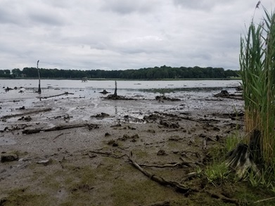
View looking out at the site of a new beneficial use project in Millsboro, DE. The area used to be a salt marsh and has been lost over the years, likely because of erosion and sea level rise.
Back in 2013, we worked closely with DNREC’s Shoreline and Waterway Management Section (SWMS) to apply a thin layer of dredge material to a struggling marsh at Piney Point along Pepper Creek. We have since monitored the site every year until 2019. Elevation sufficiently increased from the sediment application such that we saw plant life rebound and thrive in the years after. Seeing how successful the Piney Point project was, we were eager to try another similar project in Delaware.
In 2019, we identified a candidate project site along the Indian River in Millsboro. We saw in aerial imagery that what used to be coastal forest and tidal wetland has since eroded and retreated. Now, there is an intertidal mudflat that is completely devoid of plant life. The remaining marsh is likely to continue retreating if we don’t help the marsh recover.
By rebuilding this former tidal wetland, we will be recreating important wildlife habitat and better protecting nearby public infrastructure from storms and rising seas. We will also be testing a new method of tidal wetland restoration in Delaware involving thick sediment application. Previously at Piney Point, we applied a much thinner sediment layer to an existing marsh. For this project, we will apply a thicker layer to recreate a marsh that has been lost. We will be learning important new lessons about tidal wetland restoration by using this different method.
To ensure the success of this beneficial use project, we have been working closely with DNREC’s SWMS every step of the way, just as with Piney Point. The SWMS dredges the Indian River annually to maintain the navigation channel. Usually, they place dredged sediment near the project area in what is called a confined disposal facility (CDF) in a nearby upland. The SWMS will divert dredged sediments to the mudflat for this project instead of to the CDF. We will use that sediment to rebuild the former marsh.
We collected important baseline field data before applying any sediment in order to create an accurate design plan. Baseline data included current site elevation, water levels, and elevations where different plants in the area are growing.
We used the water level data to accurately predict tides at the site, which is necessary for performing fieldwork. We were also able to determine mean high water (MHW) and mean low water (MLW) at our site, both of which are important to know for permitting and for planting.
Additionally, we were able to use plant elevation readings to figure out our target elevation to rebuild the marsh. Our goal is to encourage the growth of the low marsh plant, saltmarsh cordgrass (Spartina alterniflora), and discourage the growth of the invasive European reed (Phragmites australis). Therefore, we chose a target elevation that is optimal for saltmarsh cordgrass, but not for European reed. We then calculated approximately how much sediment we will need to achieve that target elevation by using the mudflat elevation data.
We plan to apply dredged sediments to the project site over 2 winters (winter 2020/2021, and winter 2021/2022) to account for the high sediment need. Once sediment application is complete, we will plant the site with native seeds to help it recover.
Recovery will likely take several years, after which we hope to have achieved the following goals:
As with any wetland restoration project, it’s important to monitor the area over time. Monitoring allows scientists to determine if project goals are being met. For our monitoring plan, we paired our project site with a ‘reference marsh’. The reference marsh is a nearby salt marsh that is in relatively good condition that will not receive sediment. The reference site will help us see if conditions at the project site eventually approach natural salt marsh conditions.
We have recently collected a variety of data at both the project and reference sites before any sediment has been applied. The fieldwork we performed at both sites to collect these data include marsh bird surveys and nekton (free-swimming organisms) surveys. We also performed vegetation surveys, bearing capacity (marsh stability) surveys, and benthic infauna surveys. In addition, we installed several sediment plates to test them as methods of measuring accretion and erosion at our project site. Finally, we established several permanent photo points at the project site that will help us visually document changes over time.

WMAP collecting monitoring data. From left to right: performing nekton surveys; measuring sediment plates; performing bird surveys.
We will collect data in the same fashion after sediment is applied to the project site for several years. By comparing the project site and the reference marsh both before and after sediment application, we will better be able to attribute any changes we see to our wetland restoration methods instead of to natural variability.
Stay tuned for more updates!
This project is being conducted in partnership with DNREC’s Shoreline and Waterway Management Section. For more information or questions about this project, please contact Alison Rogerson at alison.rogerson@delaware.gov or 302-739-9939.