Delaware Wetlands logo
WMAP Blog


Facebook  Twitter  Instagram  YouTube  RSS Feed

  Archived Posts From: 2016

uncategorized

May is American Wetlands Month

Written on: May 30th, 2016 in Outreach

lewes-install-complete2015American Wetlands Month was established by the U.S. Environmental Protection Agency in 1991 as a way to bring federal, state, and local organizations together to highlight the importance of wetlands to the environment, the economy, and the nation’s citizens.

“American Wetlands Month is a great time to discover the importance of wetlands and the significant benefits they provide,” said DNREC Secretary David Small. “Wetlands contribute to the quality of life in Delaware by protecting people and property from flooding and coastal storms, filtering pollutants from water, increasing fish and wildlife habitat and helping reduce the impacts of sea level rise. Efforts to protect and restore wetlands are critical to ensuring their economically valuable services.”

In support of American Wetlands Month, we have organized programs that raise awareness about wetland health and benefits, and encourage actions to protect them.Wetland Apprentice Banner


wetland-animals

It’s Horseshoe Crab Counting Season

Written on: May 30th, 2016 in Wetland Animals

Horseshoe Crabs. Credit: DNERR

Horseshoe Crabs. Credit: DNERR

Guest writer: Maggie Pletta, DNERR

The Delaware Bay is home to the largest population of horseshoe crabs in the world, which is just one of the many reasons the Delaware Bay is so special. The horseshoe crab has been around since before the dinosaurs and is an important animal to the ecosystem and to humans. Their blood is used in the production of LAL (Limulus Amebocyte Lysate) for testing the sterility of medical equipment; their eggs are the food that ensures migratory shorebirds can reach their destinations; and the crabs themselves are part of a thriving commercial fishery. However, since there are so many uses and needs of this extraordinary animal it is important that their numbers are tracked and managed.

Counting horseshoe crabs with a quadrat. Credit: DNERR

Counting horseshoe crabs with a quadrat. Credit: DNERR

To do this every year hundreds of volunteers assist organizations like the Delaware National Estuarine Research Reserve (DNERR) to complete surveys of spawning crabs on Delaware Bay beaches every May and June during the full and new moons. During those moon phases the bay experiences the highest high tides, which is when the horseshoe crab comes up from its watery habitat to leave small green eggs in the wet sand. The volunteers head out on these nights, no matter how late, and walk a one kilometer distance on the beach stopping every 20 meters to count crabs. To ensure the volunteers are counting crabs in a standard size area, one meter by one meter square, they use a quadrat that they lay down on top of the crab line. Once the quadrat is down the volunteers count the number of male and female crabs, and then they pick up the quadrat and head down the beach to their next site. In all, one hundred samples are taken every night on every beach surveyed.

Once the data is collected for the season it is sent to Limulus Laboratories in New Jersey where the data is analyzed and compiled into an annual population report. This report is important because it is what resource managers use to set the harvesting regulations on the horseshoe crab in the Delaware Bay. And the volunteers are the key to a successful survey because without them we would never have enough people to complete the survey and collect this valuable data.

If you are interested in assisting with the survey next year you can contact Drexel Siok and Maggie Pletta, the spawning survey coordinators for the DNERR, or visit their survey website.


Tags: ,

wetland-animals

Peepers, Marbles, and Tigers, Oh My!

Written on: March 14th, 2016 in Wetland Animals

WetlandThanks to all that extra water lying around, all sorts of amphibians start to come alive this time of year in Delaware. Frogs and salamanders use these seasonal pools of water, or wetlands, to breed and can only do so because predatory fish cannot survive the lack of permanent water. They then use the surrounding drier wetlands and uplands as summer habitat.

Northern Spring Peeper (USFWS)

Northern Spring Peeper (USFWS)

In your travels you may have started to hear the sounds of the Spring Peeper. Their sound is a high pitched “peep peep peep” and when singing together it has been said, they sound like a chorus of bells.  The Spring Peeper males use these sounds to attract a mate, and are one of the earliest breeding frogs you will find in the State. They are brown to grey in color and can be identified by an X-marking on the back.

Marbled Salamander (WMAP)

Marbled Salamander (WMAP)

Spotted, Marbled and Eastern Tiger Salamanders are just a few of the salamanders that roam the state.  These salamanders are in the mole salamander family because they spend most of their adult life under leaves, logs or in holes or burrows in the ground. They only return to the water, such as that in vernal pools, to breed during the winter/spring months.

Want More Delaware Amphibian Info?
Wetlands 101: Wild Wetlands
DE Herps ID Cards
USGS Frog Call Lookup
An Introduction to Mid-Atlantic Seasonal Pools

Tags: ,

wetland-assessments

Mispillion Watershed Health

Written on: March 14th, 2016 in Wetland Assessments

Mispillion Watershed is highlighted in red.

Mispillion Watershed is highlighted in red.

Updated: 10/28/2016, Grading scale was revised.

In the summer of 2012, DNREC’s Wetland Monitoring & Assessment Program rated the health of wetlands in the Mispillion and Cedar Creek River Watershed’s tidal and non-tidal flat and riverine wetlands. The goal of this project was to summarize recent gains and losses in wetland acreage, assess the condition, and identify impacts on the wetland. The watershed received an overall grade of C; broken down into tidal wetlands receiving a B-, non-tidal flat wetlands receiving a C+, and non-tidal riverine wetlands receiving a C-. This was the sixth watershed in Delaware to be assessed.

The Mispillion Watershed lost 20% of wetlands since the early 1700s, with the majority due to conversion of land to agricultural fields or developments and erosion from rising sea levels.


Comparison of wetlands across six of Delaware's watersheds.

Comparison of wetlands across six of Delaware’s watersheds.

The three most common impacts to wetlands were the:

  1. Presence of invasive plants (such as Phragmites) that can out grow native plant species
  2. Ditching of wetlands to remove its ability to hold water
  3. Agriculture or development just outside the wetland blocking its ability to migrate landward.

The full report, data and report card are now available online.


Tags: , , ,

uncategorized

Coastal Storms, Wetlands & You

Written on: March 14th, 2016 in Outreach

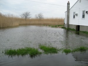
Coastal FloodingWinter storms and nor-easters brought excess rainfall, rough seas, and unseasonably high tides to Delaware this winter, highlighting the value of nature’s first line of defense against coastal storms; wetlands. Up and down Delaware’s coast, roadways were made impassable due to rising seas, buildings were battered by winds and water, and dunes and boardwalks were washed away by angry waves.

But don’t’ fret, there is hope in minimizing the effects of storms on your property: Protect, Preserve and Restore Wetlands! Wetlands have the innate ability to store flood waters, buffer storm surges, and prevent erosion. Did you know that peak floods can be reduced up to 60% in watersheds that contain 15% wetlands(NOAA Digital Coast)?
There are multiple things you can do to protect and preserve wetlands:
  • Plant native species of trees, shrubs and flowers. For help with plant selection please visit the University of Delaware Cooperative Exentsion
  • Use living shoreline techniques to stabilize your shoreline instead of hardened structures.
  • Avoid wetlands if you are building structures or landscaping
  • Volunteer with a local group to help maintain wetlands.  For example: Beach Grass Planting – March 19, Jennifer.Luoma@delaware.gov
  • Pick up all litter and dispose or recycle in appropriate trash containers
  • Report illegal activities such as filling, clearing, or dumping in a wetland to the DNREC complaint hotline 1-800-662-8802
  • Learn More With:

Tags: ,

wetland-assessments

Getting to Know Delaware’s Non-Tidal Wetlands: Appoquinimink Watershed

Written on: March 8th, 2016 in Wetland Assessments

Every summer since 1999 our Program has gone out into the wilderness to assess non-tidal wetland health in Delaware’s different watersheds. Why you ask? Well, we want to see how healthy Delaware’s wetlands are and if they are able to perform the natural tasks that make them so valuable. We identify which wetlands are in good shape, areas where wetlands are not doing so well and why, and highlight ones that could use a little tender love and care (AKA, they are good candidates for restoration and protection).

Watershed-DiagramIn 2015, we focused on the Appoquinimink Watershed located in the northern third of Delaware. A watershed is an area of land in which all water drains and runs off towards a specific body of water, in this case the Appoquinimink River, and has a natural boundary defined by the tops of hills or ridges.

To begin our expedition, we divided the wetlands up by type depending on how they receive their water (groundwater, surface water flow, and precipitation) and where they exist (along a stream, in a shallow depression, and on forested terrace). Then we randomly selected wetland points on a map to be evaluated. We ended up visiting 31 headwater flats, 35 riverine and 29 depression wetlands throughout the summer in the Appoquinimink Watershed.  As we hiked through each of the 95 sites, our team looked for a variety of features that could cause a wetland to be stressed or impacted.  These features, or stressors, are broken up into three categories: habitat, hydrology and buffer.
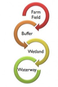
Nutrients and pesticides (shown as red) in runoff are reduced as water moves from farm field to buffer to wetland to waterway.

Figure 1. Nutrients and pesticides (shown as red) in runoff are reduced as water moves from farm field or yard to buffer to wetland to waterway.

Habitat stressors involve the physical and biological characteristics of the wetland and can include presence of invasive plants, excess nutrients, forest harvesting, farming or roadways.

Next up are the hydrologic stressors. Hydrology deals with water; what it is doing and where it is located (or not located) in the wetland. Some of the questions we ask ourselves are: Have ditches been added to the wetland? Has the stream channel been straightened or deepened? Does it have a stormwater pipes or point source pollution entering? Has it been filled or dug out?

Last on the list to take a look at are the buffer stressors. A buffer is a zone of land just outside of the wetland that has the ability to protect a wetland from disturbances occurring in the surrounding upland landscape. If severe impacts are too close to a wetland, it may overwhelm it causing it to not function properly. If a wetland has a good buffer, then it has a first line of defense against excess nutrients, pesticides or soil runoff, and that wetland can further protect pollution from entering waterways (Figure 1.). Some of the buffer stressors that we look for include farming practices, developments, roads, landfills, golf courses and ditches.

Why don’t you give identifying wetland stressors a try. Can you identify the major stressor that was put in the below wetland?

Aerial view before Route 1 was put in (1992) and after (2012). Wetland is in yellow circle.

Aerial view before Route 1 was put in (1992) and after (2012). Wetland is in yellow circle.

If you guessed roadway, then you were right! As we go through each of these stressor categories at a site, we mark down what we see (like the roadway in the above picture), and tally everything up to give that wetland a score. The more stressors at a site, the lower the score, the poorer the health of that wetland. We are currently in the process of compiling all 95 scores for the a Wetland Health Report on the Appoquinimink Watershed.

The information gathered in this report will be used to compare wetland health across Delaware’s watersheds and make recommendations to landowners and policy makers to improve the health of Delaware’s wetlands. Be on the lookout for the Appoquinimink report in 2018.

Want more information on this process? Check these resources out:
Delaware Rapid Assessment Procedure
Watershed Wetland Health Reports


Tags: , ,
+