Facebook Twitter Instagram YouTube RSS Feed

Written on: May 18th, 2018 in Wetland Restorations
by Mark Biddle, DNREC Wetland Monitoring and Assessment Program

The Delaware Watershed Resources Registry (WRR) is an online GIS mapping tool that is useful for prioritizing preservation and restoration of several important land types, including wetlands.
In our everyday lives, we are always looking to find efficiency with our time and make tasks easier. If you were planning a project, how would you feel if 30-40 percent of pre-project planning was already done for you? You would likely say, “Yes, please!” Well that’s exactly what the Delaware Watershed Resources Registry (WRR) provides for projects in the open environment. The WRR is an online GIS mapping tool that prioritizes areas for preservation and restoration of wetlands, riparian zones, terrestrial areas, and stormwater management control. The 8 models within the WRR help you find opportunities for restoration and preservation when needed to either improve or preserve the condition of areas on the landscape, or can be used to locate replacement resources for unavoidable environmental impacts. This online tool provides assistance to developers, natural resource planners, consultants, transportation planners, conservation organizations, and local land use planners.
To offer an example of the utility of the WRR, let’s first look to a typical DelDOT project involving a new road. The process involves consideration of a handful of different alignments – basically, different pathways the new road could take. Each one of these pathways has to be evaluated for its potential costs and for its impact to natural or built resources. The WRR is the tool planners would use as a filter or first-cut at determining which new road pathways are the best or the worst as far as costs and impacts. The information within the WRR allows DelDOT planners to see all the geospatial data together at one time. Prior to having the WRR, planners would have to assemble all of this data separately for each and every project. Previewing the data all together leads to avoiding potential ‘roadblocks,’ such as contaminated sites, wellhead protection areas, underground storage tanks, high quality ecological habitat, etc. – the characteristics that can be difficult to deal with during permitting and construction, and typically increase the overall cost of the project. Once DelDOT settles on the best new road alignment, planners can then use the restoration and preservation opportunities provided by the 8 models in the WRR to find sites to offset unavoidable impacts and produce required mitigation.
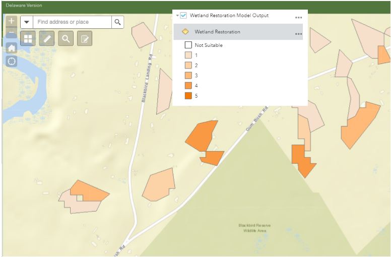
Figure 1. WRR output showing opportunities from the wetland restoration model near the Blackbird Creek Reserve in Delaware.
The WRR provides the same utility to consultants and developers planning a new residential development. The online mapping tool shows where many resources exist on the landscape and is able to incorporate these considerations into the development layout from very early in the process, which saves time and money further into the process if changes are made or required by permitting agencies. The preservation and restoration opportunities within the WRR are also useful to conservation organizations conducting preservation and restoration on their lands. Each of the 8 models scores preservation and restoration opportunities using a 1-5 scale, with 5 being the best (Figure 1).
For those of you who may use the WRR online tool, it is no different than any other landscape-level mapping resource; it’s very informative, should be used strictly as guidance, and any opportunities identified in the WRR should be verified on the ground. The WRR concept was designed by Maryland Environmental Services in partnership with the Environmental Protection Agency initially as a tool for the Maryland DOT to assist with their permitting and regulatory needs. Because of the flexibility of the WRR, it evolved into an online resource tool for more than just DOT projects. With funding assistance from Federal Highways, the Delaware WRR used the same structure and models, and formed a technical advisory committee to determine the best geospatial data to inform each of the 8 models. The geospatial data is all publically available and is either pulled from the Delaware FirstMap site, or from other nationally available datasets. The WRR provides a single tool for many users and provides project efficiency, consistency, ease of use, and cost effectiveness.
Delaware's Governor
State Agencies
Elected Officials
General Assembly
Delaware Courts
State Employees
Cities & Towns
Delaware State Code
State Regulations
Business First Steps
Phone Directory
Locations Directory
Public Meetings
Voting & Elections
Transparency
Delaware Marketplace
Tax Center
Personal Income Tax
Privacy Policy
Weather & Travel
Contact Us
Corporations
Franchise Tax
Gross Receipts Tax
Withholding Tax
Delaware Topics
Help Center
Mobile Apps
E-mail / Text Alerts
Social Media

Built by the Government Information Center
©MMXVIII Delaware.gov

