Facebook Twitter Instagram YouTube

Written on: September 26th, 2022 in Wetland Assessments
By Alison Rogerson, DNREC’s Wetland Monitoring and Assessment Program
Over the past year plus I’ve written five blogs sharing the results of our 2007-2017 Status and Trends report which reviews many angles of Delaware’s wetlands based on analysis of the 2017 Statewide Wetland Mapping Project (SWMP). In this post I am focusing on final thoughts and discussion of everything presented. It’s a lot of information to boil down, so based on everything we found with wetland acreage, gains, losses, and changes what are the key takeaways?
Tidal Wetlands
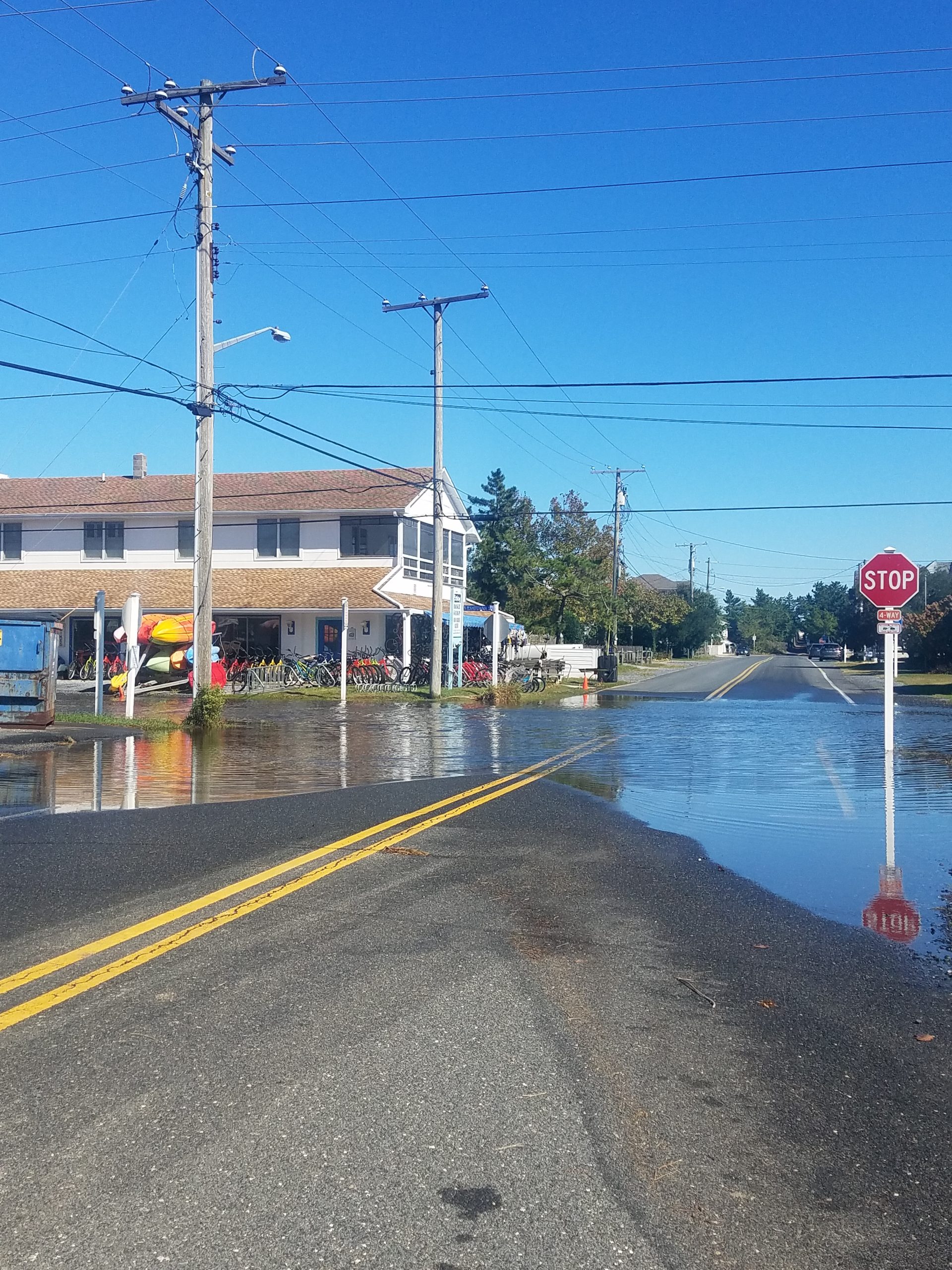
On the tidal wetland front, net losses were around 100 acres and mostly due to environmental forces such as erosion and sea level rise, mostly in the Delaware Bay. This is similar to findings from 1992-2007. We documented a lot of tidal fresh wetlands becoming tidal as salt water lines creep higher and higher up tributaries, changing the wetland community over time. This shifting upstream of tidal fresh wetlands is vital to their survival and is only possible when tributaries are free flowing and not blocked by dams and control structures.
We also documented some tidal wetland gains as a result of marsh migration inland. This is a good sign that wetlands are attempting to seek new territory as sea levels rise. However, marsh migration only works if the wetland to upland border is not built up with berms or hardened by structures such as roads and bulkhead. This requires planning ahead and leaving room. Fingers crossed that wetlands can migrate as fast as sea level rise is coming behind them.
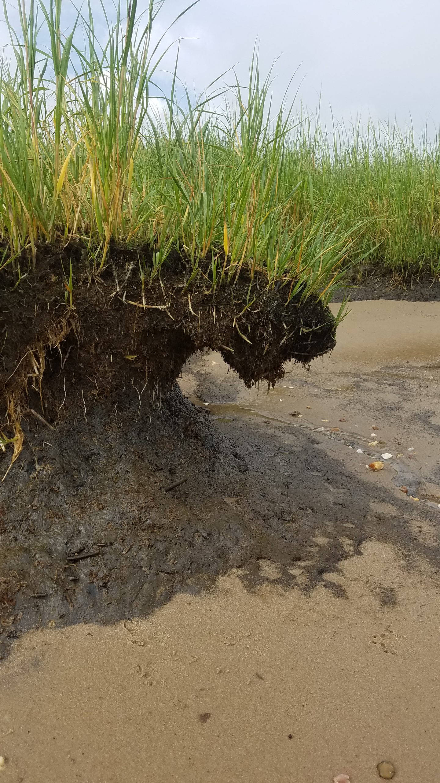
Not too bad so far, right? The more concerning discovery was that a significant portion of tidal wetland changes (65%) were due to vegetated wetlands turning into basically mudflats. They have not yet washed away into open water habitat but without communities of Spartina and other grasses their capacity to function drops way down. The next step here is being washed away completely so resilient shoreline stabilization tactics become very important to prevent future erosion and loss. We can’t stop sea level rise but we can slow down the impacts.
Lastly, improved mapping technology allowed us to label tidal wetland areas that were dominated by the invasive reed Phragmites australis. This feature allowed us to identify that over half (52%) of all high marsh areas in tidal wetlands contained or were dominated by Phragmites. Phragmites preys on recently disturbed areas, areas with altered water regimes and along the wetland to upland border. Once it takes over, it is very difficult to remove so prevention and control is crucial. This baseline reading will be useful to compare against in another 10 years.
Non-tidal Wetlands
On the non-tidal wetland front, the picture was definitely more bleak. Delaware logged a net loss of 2,534 acres of vegetated non-tidal wetlands between 2007 and 2017. Gross losses were even more. This is, again, on track with our findings from 1992-2007. The Chesapeake Bay basin bore the brunt of the losses, accounting for 62% of statewide totals even though the Chesapeake Bay basin makes up only 34% of statewide acreage.
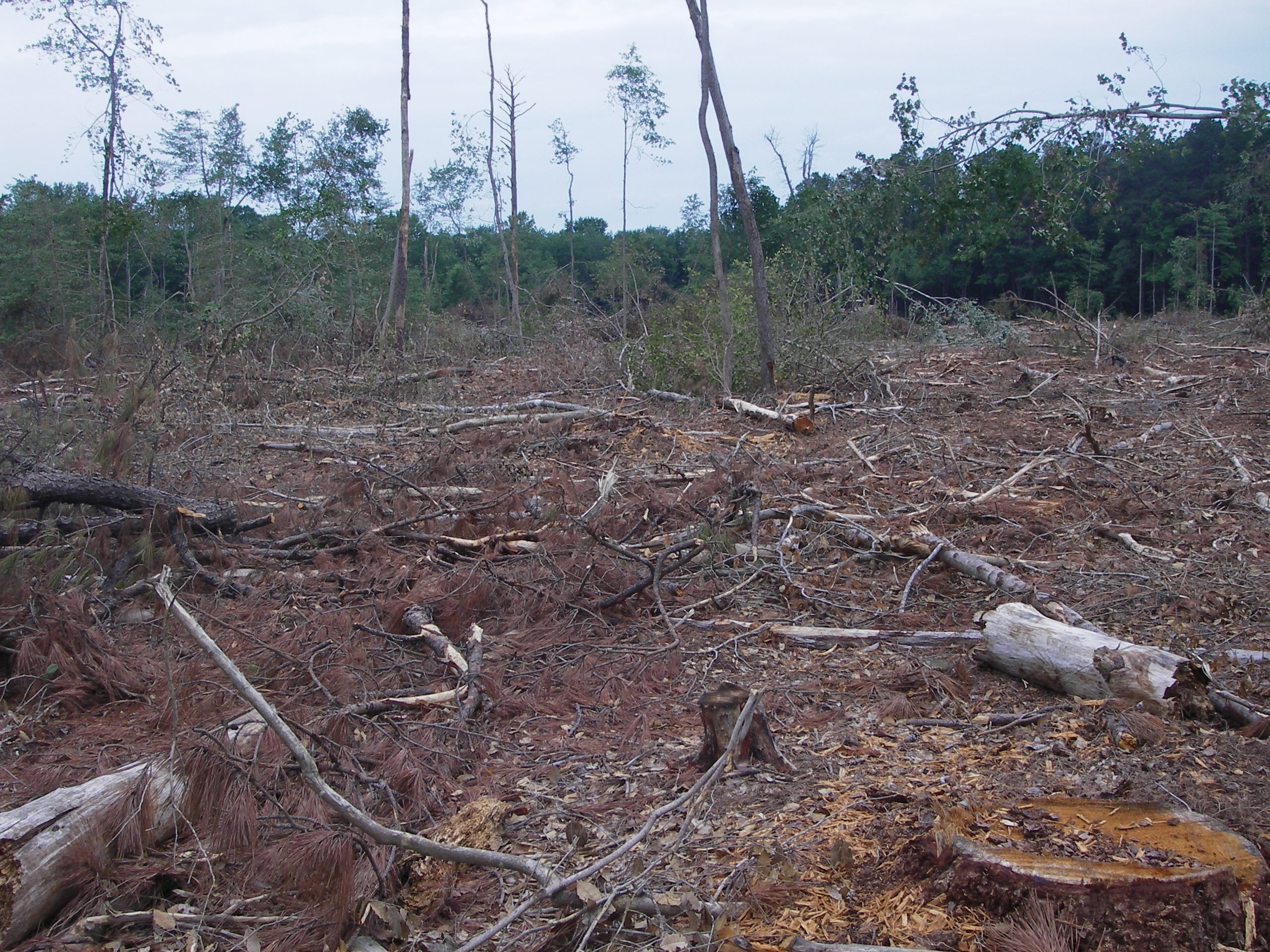
Non-tidal wetland losses were associated with clearing for logging activities (54%), development (24%), and agriculture (19%). This pattern is consistent with non-tidal wetland losses from 1992-2007. A small portion were due to transportation and utility impacts (3%). Although timber harvesting is a renewable resource, impacts to wetland hydrology and habitat are significant and wetland function will take decades to become restored. Impacts to headwater forested wetlands were most common and leads to reduced ability to filter excess nutrients and pollutants from water moving through them.
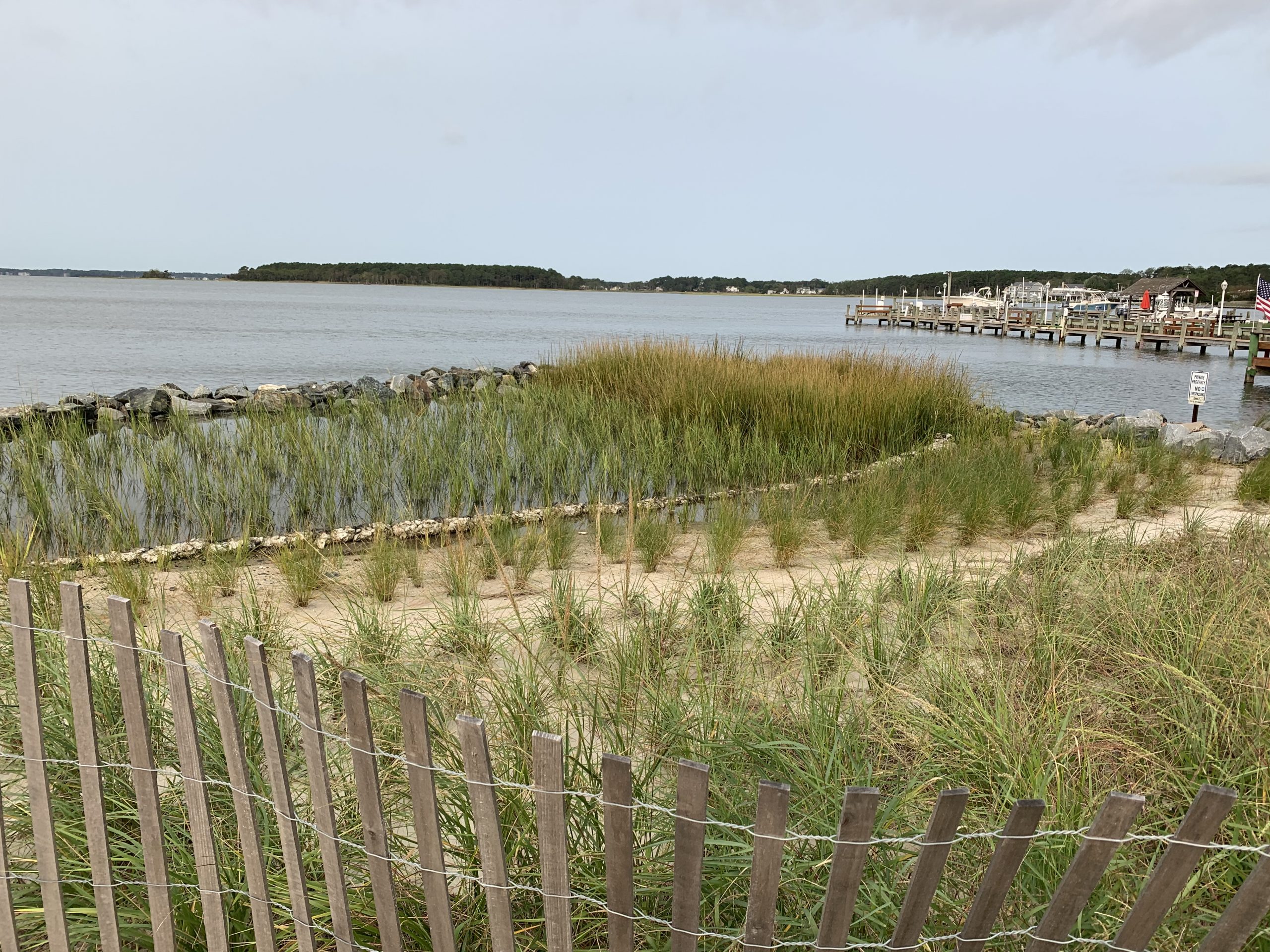
Although the gross loss of non-tidal wetland loss was lessened by wetland gains, those gains were in the form of created stormwater ponds. In fact, 81% of non-tidal wetland gains were as unvegetated, open water retention ponds, usually in residential developments or on farms. Stormwater ponds offer severely reduced functions, providing limited wildlife habitat, water filtration and sediment retention services and are not an even trade for the loss of natural wetlands. Wetland creation should replace the impacted wetland type.
Changes for non-tidal wetlands were mostly (71%) related to a shift in cover types. For example from forested to scrub-shrub as a result of forestry clear cutting starting to recover or a scrub shrub area maturing into a forested wetland. Another portion of non-tidal wetlands (15%) changed from non-tidal to tidal fresh as the salt water lines creep further upstream and flooded conditions increase. This could cause forested wetlands to become emergent. Stands of dead trees in coastal areas, or ghost forests, are becoming a noticeable sign of salt water intrusion, sea level rise and a shift in forested communities.
At the end of the day, every wetland trend comes with an associated shift in wetland function. By far, Delaware lost more wetlands in ten years than were created and with those losses come a reduction in storm protection, erosion control, water filtration, water storage, fish and shellfish production, breeding bird habitat, and carbon sequestration. Created wetlands don’t provide comparable services and functions to natural wetlands and likely won’t for several decades. It is these long term functional impacts that we need to be thinking about in the next ten years and hopefully Delaware can break away from the trend of wetland losses that have been in place since the 1990’s and earlier. Small impacts here and there add up over decades and lead to a fractured resource network that cannot provide the valuable services that we expect to serve us for free.
Check back in December for the final post in this series focusing on what we do next with management recommendations.
Delaware's Governor
State Agencies
Elected Officials
General Assembly
Delaware Courts
State Employees
Cities & Towns
Delaware State Code
State Regulations
Business First Steps
Phone Directory
Locations Directory
Public Meetings
Voting & Elections
Transparency
Delaware Marketplace
Tax Center
Personal Income Tax
Privacy Policy
Weather & Travel
Contact Us
Corporations
Franchise Tax
Gross Receipts Tax
Withholding Tax
Delaware Topics
Help Center
Mobile Apps
E-mail / Text Alerts
Social Media

Built by the Government Information Center
©MMXVIII Delaware.gov

