Delaware Wetlands logo
WMAP Blog


Facebook  Twitter  Instagram  YouTube  RSS Feed

  Archived Posts From: 2017

beneficial-use

Beneficial Reuse of Dredge Material on a Tidal Marsh

Written on: May 24th, 2017 in Beneficial Use

Dredge definitionWhat is one way to give a marsh a lift with the challenge of rising seas? Spray the muddy material that has been dredged up from the bottom of a creek in a thin layer on top of the marsh. But how much mud is too much, and can the plants survive? These are a couple of the questions we (Wetland Monitoring & Assessment Program) set out to answer.
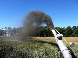
In 2013, Pepper Creek in Dagsboro was set to be dredged, so we rallied the troops and came up with a plan to test out how the beneficial reuse of dredge materials (also called thin layer application) affect marshes in Delaware. The resulting spoils from dredging were thinly sprayed over the marsh at the Piney Point Tract of the Assawoman Wildlife Area, and long term monitoring stations were set up.

Dredge material being sprayed on marsh surface.

Dredge material being sprayed on marsh surface.

For the past three years we have been looking at how the plant community has responded to the application, and how the marsh surface has changed by performing Real Time Kinematic (RTK) GPS transect surveys of the area and measuring surface accretion with feldspar marker horizon plots.
From the data we have been gathering we’ve figured out a couple of things that work and some things that need further study for future projects:
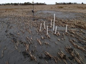
feldspar plot in application area

Feldspar assessment plot in a thin layer dredge application area.

  • Aerially broadcasting dredge material is possible! But, spray distances are limited by debris in the water and wind. It is also difficult to precisely measure how much mud is being applied.
  • Having responsive dredging and spraying teams are crucial. Unexpected things happen, so having a team that is ready to respond to changes –whether it be a quick turn of the spray nozzle to a different area or paying attention to weather patterns that may affect the project—can be extremely helpful. (Freezing conditions can cause issues.)
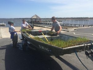
  • spartina-plants-about-to-head-out-to-be-planted

    Smooth cordgrass plants on their way to being planted in bare areas of the dredge application area.

    Establish a limit to the amount of mud that can be sprayed in the application area. For our area, we suggest approximately 10 to 12 centimeters. The plants in areas that were more thickly sprayed with mud still struggle to grow through the mud. To supplement these thickly applied areas, we planted 2600 smooth cordgrass (Spartina alterniflora) plugs to try and fill in the bare areas. We even started a mini-experiment to see if planting in clumps verses rows allows the little beauts to survive better. We’re still collecting data on the mini-experiment, but hope to have some interesting results soon.

  • Once the thin-layer of sediment has been applied to the marsh surface, it takes time for the muddy water to level out across the marsh and for the suspended sediments to fall out of the water.
  • More information is needed on how mussels respond to being covered with mud. How thick is too thick for them?

So the nitty gritty of it is that spraying dredge materials on top of a marsh can increase the height of that marsh. But, careful attention must be paid to how thickly the mud is sprayed, and the site should be monitored for problem areas that need replanting.

This project was done in partnership with DNREC’s Shoreline and Waterway Management Section.  For more information or questions about this project, please contact Alison Rogerson at alison.rogerson@delaware.gov or 302-739-9939.


Tags: , , , , ,

wetland-assessments

Keeping an Eye on the Rising Tide: SSIM

Written on: May 24th, 2017 in Wetland Assessments

Coastal wetlands are a hallmark feature of the Delaware’s Bayshore, making up about 23% of all wetland types in the state. Because of the many beneficial services these wetlands provide, such as wave energy reduction, the survival of coastal wetlands is an important part of protecting our seaside communities from threats associated with the changing climate.

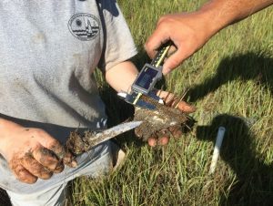
SSIM Feldspar Monitoring

Measuring the amount of sediment on top of a feldspar (a type of clay) marker for a SSIM site.

We here at DNREC’s Wetland Monitoring & Assessment Program (WMAP) are doing our part to track changes in coastal marshes with the long-term monitoring of fixed sites in the Christina and Broadkill watersheds.

To do this, we’ve joined in on the Mid-Atlantic Coastal Wetland Assessment (MACWA) method by maintaining Site Specific Intensive Monitoring sites, also called SSIM (pronounced sim). This monitoring effort establishes fixed stations in coastal marshes and looks at a couple of different factors including water quality, soil quality, plant community, and marsh surface characteristics to help determine if that marsh is capable of keeping up with sea level rise.
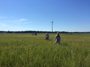
walking-out-to-ssim-site

Scientists from WMAP and PDE walking out to SSIM field site to begin monitoring efforts.

There are currently seven fully established SSIM stations in the Delaware Bay Estuary network with two of them residing right here in the little state we call home, Delaware. Two or three times a year, three to four scientists (or scientists in training) slide on their hip boots, head out to the marshes and gather data.

The first SSIM site was installed in Delaware in 2010 on the Christina River in the Russell Peterson Urban Wildlife Refuge. This site is a freshwater site that is impacted by both the past and current chemical industry and from marsh fragmentation caused by the construction of highways in the 1960’s.

The second site in Delaware is located in the Great Marsh Preserve along Canary Creek, an offshoot of the Broadkill River, in Lewes and was installed in 2014. This station is the most downstream location out of the seven in the Delaware Bay Estuary and has the saltiest water of all of the sites because of its proximity to the Atlantic Ocean. The surrounding landscape of this area is agricultural, with some housing communities. Like most salt marshes along the east coast, these areas were historically ditched for mosquito population control.

With each passing year we gather more and more data at these two SSIM sites that will help us understand more about our marshes’ ability to keep up with sea level rise. Be on the lookout for future updates about this project!

This project is done in partnership with the Partnership for the Delaware Estuary (PDE).


Tags: , , , ,

uncategorized

Floating Wetlands

Written on: May 24th, 2017 in Outreach

Guest Writer: Phil Miller, DNREC’s Nonpoint Source Program
YCC preparing to install floating wetlands

The Delaware Youth Conservation Corps preparing to install floating wetlands at Trap Pond State Park.

We’ve all heard about wetlands before but have you ever heard of a floating wetland?

Floating wetlands are artificial islands with plants on top and roots below. Similar to a natural wetland, they improve water quality by soaking up nutrients, such as nitrogen and phosphorus. These two nutrients are the primary causes of algal blooms, which make it difficult for fish and other aquatic life to survive.

Every time it rains, pollutants from lawns, roads, and other surfaces are swept into our waterways. Fortunately, we’re able to battle this runoff with floating wetlands, an efficient tool for cleaning polluted water. As the plants of the wetlands grow, they remove nutrient pollution and store it in their leaves while adding life-giving oxygen to the water. At the same time, their roots provide a home for microorganisms that feed on pollution.

The only element needed for all this to work? Simple sunlight.

Floating Wetland End of Season 2

Floating wetland in the fall of season 2.

In 2015 DNREC purchased twelve floating rafts and native plants which were then linked together to form two groups of floating wetlands. The Delaware Youth Conservation Corps installed the two wetlands at Trap Pond during the Nanticoke Watershed Alliance’s annual Wade In and Nanticoke River Report Card Release event. Since then, it’s been a huge hit, not only for the students who got to install them, but also for everyone else at the park that couldn’t wait to hop in a kayak and paddle out to see them.

Over the past couple years, the wetlands have flourished and have been a destination point not only for curious paddlers but also for fisherman hoping to catch one of the many fish that find habitat in the cooler cleaner water below the raft’s root system.

Luckily, the geese have not been interested in joining in the fun. If that had occurred, there were certain plants that would have been added to deter them as well as other techniques that would have been put in place but proved not to be necessary. The turtles on the other hand, call it home –finding food and a place to sunbathe.

Floating Wetland Spring of Season 3

Floating wetland in the spring of season 3.

Due to the huge size of the pond, water quality improvement was not the intention of this project. This is simply a demonstration project that provides an opportunity for people to see what they are and learn about how they work.

Trap Pond is an ideal setting, not only because of the traffic through the park –the fisherman, paddlers, boaters, hikers, campers, students and anyone who passes them, but also because of the accessibility. To be able to paddle out and get a close up look at exactly how it’s working has been enjoyed and appreciated by the park’s visitors since the day they were installed. They’ve since been added as an educational component of the pontoon tours and canoe and kayak trips.

Stop by Trap Pond to see their progress this summer!


Tags: , , ,

wetland-restorations

Re-Engineering Nature in Delaware Tax Ditches

Written on: May 22nd, 2017 in Wetland Restorations

Guest Writer: Melissa Hubert, DNREC’s Drainage Program

Fun fact, did you know that there are 234 tax ditch organizations scattered across Delaware that provide water management services to over 100,000 residents and nearly half of the state-maintained roads?

These watershed based organizations are responsible for maintaining over 2,000 miles of ditch channel to ensure the drainage functionality of these systems stays running strong. This is no easy feat considering most tax ditches were constructed over 30 years ago when the landscape across Delaware looked much different. The aging infrastructure of most tax ditches in conjunction with landuse changes have resulted in major maintenance concerns that need to be addressed.

Conditions of the Bridgeville Branch Tax Ditch channel before the stream restoration project. Note the straight channel.

Conditions of the Bridgeville Branch Tax Ditch channel before the stream restoration project. Note the straight channel.

As these engineered systems attempt to handle stormwater flows that they were not designed for, the ditch channels often undergo changes caused by moving water that deepen and widen the channels, cause bank erosion, and create sediment bars. These side-effects change the ditch systems from their original designs which in turn, may limit their water capacity, decrease response time to storm events, and make it more difficult to perform channel maintenance.

Bridgeville Branch Tax Ditch channel after the stream restoration project was completed. Note the meander of the channel, which is similar to the flow of natural streams

Bridgeville Branch Tax Ditch channel after the stream restoration project was completed. Note the meander of the channel, which is similar to the flow of natural streams

The DNREC Drainage Program is working with tax ditch organizations to determine ways to mimic natural in-stream processes and features with the goal of minimizing maintenance needs while still enhancing the ability of these systems to transport and clean water.

Here’s an example of one of those projects:

A portion of the Bridgeville Branch Tax Ditch, located in the Town of Bridgeville, was undercutting and widening to the point that both a sanitary sewer and water line were exposed within the channel. For a permanent solution to this serious issue, the exposed lines were properly encased and a channel that mimics a natural stream was constructed to further protect and enhance the project area.

Soil lifts with live branch cutings placed between each layer to protect this bend where the sanitary sewer line is located and improve in-stream habitat.

Soil lifts with live branch cutings placed between each layer to protect this bend where the sanitary sewer line is located and improve in-stream habitat.

Natural streams transport water through the path of least resistance and as a result, many twists and turns tend to develop as water moves. For this project the ditch channel was re-aligned to establish a meandering flow path with adjacent floodplain benches to reduce the energy moving through the channel during normal and higher storm flow conditions.

In addition a stilling basin was constructed just downstream of four large pipes to slow the water when it entered the project area. A series of riffle and pool structures were created to provide flow diversity within the channel. These features not only reduce future maintenance needs, but capture and prevent pollutants from being transported further downstream, and create spawning habitat for all those critters we love.

The live branch cuttings really taking off providing bank stabilization, wildlife cover, and shade for the channel.

The live branch cuttings really taking off providing bank stabilization, wildlife cover, and shade for the channel.

Tree logs and root wads were pushed into the banks to provide natural protection from erosion as well as wildlife habitat and cover. Soil lifts or soils wrapped in an organic material were installed with branches placed between each lift to restore a portion of the ditch bank that was previously lost to erosion.

Last but not least the entire project area was planted with native species of riparian grasses, trees, and shrubs with live branch cuttings planted on the banks to rapidly establish stability, shade, and in-stream cover.

In this project nature was re-engineered by implementing natural design techniques and features that not only improved the functionality of the tax ditch channel and reduced future maintenance needs but also enhanced wildlife habitat and water quality.

It is the DNREC Drainage Program’s hope to help tax ditch organizations plan and construct stream restoration projects like this one to address maintenance issues in the future.

Delaware Tax Ditch Map

Visit this site to see where tax ditches are located near you.

Interested in getting involved? Tax ditch meetings are held annually, organized by watershed, to voice maintenance concerns and other topics. Any decisions are voted on by property owners within their own tax ditch watershed. With the prevalence of tax ditch organizations across Delaware you may even live in a watershed that has one. Check out this app to find out.


Tags: , , ,

living-shorelines

Shoreline Stabilization Solutions for You!

Written on: May 22nd, 2017 in Living Shorelines

Where to Begin and an Expedited Permitting Process.

Guest Writers: Julie Molina, Katie Huegel and Matt Jones of DNREC’s Wetlands & Subaqueous Lands Section

Armored Living Shoreline

Pictured above is an armored living shoreline used in a high energy area. The project stabilized 150 linear feet of shoreline using a marsh toe sill with coir fiber logs and wetland vegetation planted behind the sill.

Delaware’s coastal communities face constant challenges from shoreline erosion. Historically, tidal wetlands act as the natural solution for shoreline stabilization. Tidal wetlands provide protection against shoreline erosion, a mechanism for flood control and natural habitat for many plant and animal species. Coastal communities today can still take advantage of having a natural means to stabilize their shorelines!

Having a natural, “living” shoreline is an increasingly popular option that provides a variety of ecological benefits while also serving a homeowner’s main goal of erosion control. For those with an interest in fishing and crabbing, the regaining of this critical riparian habitat has been proven to almost double the densities of these creatures when compared to bulkhead or riprap.

So what’s the next step?

Lewes Living Shoreline

Pictured above is a non-structural living shoreline in a low energy area. The project stabilized 84 linear feet of shoreline using coir fiber logs and wetland vegetation.

There are many different designs used when installing a living shoreline. From using coir fiber logs, to oyster castles, to a marsh toe sill with wetland plantings – the possibilities are endless. Since every shoreline is different, a site-specific design is required for successful results. Getting in contact with a consultant or contractor in order to determine which type of living shoreline would work for your property is an important next step. You can reach a consultant or contractor specializing in vegetative shoreline stabilization techniques here.

The Wetlands and Subaqueous Lands Section at DNREC has an expedited permitting process to authorize the construction of these natural living shorelines.

As long as the project meets the parameters outlined here, the Statewide Activity Approval for Shoreline Stabilization Projects can be used by coastal community residents to naturally protect their shoreline. For more information on natural living shorelines, please contact our office at (302) 739-9943.


Tags: , , , ,
+