Facebook Twitter Instagram YouTube RSS Feed

Written on: May 24th, 2017 in Beneficial Use
 What is one way to give a marsh a lift with the challenge of rising seas? Spray the muddy material that has been dredged up from the bottom of a creek in a thin layer on top of the marsh. But how much mud is too much, and can the plants survive? These are a couple of the questions we (Wetland Monitoring & Assessment Program) set out to answer.
In 2013, Pepper Creek in Dagsboro was set to be dredged, so we rallied the troops and came up with a plan to test out how the beneficial reuse of dredge materials (also called thin layer application) affect marshes in Delaware. The resulting spoils from dredging were thinly sprayed over the marsh at the Piney Point Tract of the Assawoman Wildlife Area, and long term monitoring stations were set up.
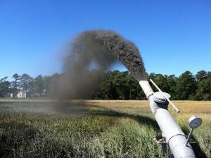
Dredge material being sprayed on marsh surface.
For the past three years we have been looking at how the plant community has responded to the application, and how the marsh surface has changed by performing Real Time Kinematic (RTK) GPS transect surveys of the area and measuring surface accretion with feldspar marker horizon plots.
From the data we have been gathering we’ve figured out a couple of things that work and some things that need further study for future projects:
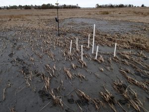
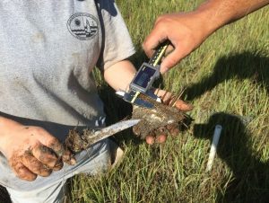
Feldspar assessment plot in a thin layer dredge application area.
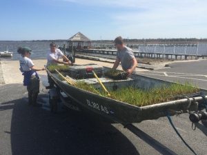
Smooth cordgrass plants on their way to being planted in bare areas of the dredge application area.
Establish a limit to the amount of mud that can be sprayed in the application area. For our area, we suggest approximately 10 to 12 centimeters. The plants in areas that were more thickly sprayed with mud still struggle to grow through the mud. To supplement these thickly applied areas, we planted 2600 smooth cordgrass (Spartina alterniflora) plugs to try and fill in the bare areas. We even started a mini-experiment to see if planting in clumps verses rows allows the little beauts to survive better. We’re still collecting data on the mini-experiment, but hope to have some interesting results soon.
So the nitty gritty of it is that spraying dredge materials on top of a marsh can increase the height of that marsh. But, careful attention must be paid to how thickly the mud is sprayed, and the site should be monitored for problem areas that need replanting.
This project was done in partnership with DNREC’s Shoreline and Waterway Management Section. For more information or questions about this project, please contact Alison Rogerson at alison.rogerson@delaware.gov or 302-739-9939.

Written on: May 24th, 2017 in Wetland Assessments
Coastal wetlands are a hallmark feature of the Delaware’s Bayshore, making up about 23% of all wetland types in the state. Because of the many beneficial services these wetlands provide, such as wave energy reduction, the survival of coastal wetlands is an important part of protecting our seaside communities from threats associated with the changing climate.
Measuring the amount of sediment on top of a feldspar (a type of clay) marker for a SSIM site.
We here at DNREC’s Wetland Monitoring & Assessment Program (WMAP) are doing our part to track changes in coastal marshes with the long-term monitoring of fixed sites in the Christina and Broadkill watersheds.
To do this, we’ve joined in on the Mid-Atlantic Coastal Wetland Assessment (MACWA) method by maintaining Site Specific Intensive Monitoring sites, also called SSIM (pronounced sim). This monitoring effort establishes fixed stations in coastal marshes and looks at a couple of different factors including water quality, soil quality, plant community, and marsh surface characteristics to help determine if that marsh is capable of keeping up with sea level rise.
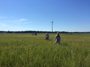
Scientists from WMAP and PDE walking out to SSIM field site to begin monitoring efforts.
There are currently seven fully established SSIM stations in the Delaware Bay Estuary network with two of them residing right here in the little state we call home, Delaware. Two or three times a year, three to four scientists (or scientists in training) slide on their hip boots, head out to the marshes and gather data.
The first SSIM site was installed in Delaware in 2010 on the Christina River in the Russell Peterson Urban Wildlife Refuge. This site is a freshwater site that is impacted by both the past and current chemical industry and from marsh fragmentation caused by the construction of highways in the 1960’s.
The second site in Delaware is located in the Great Marsh Preserve along Canary Creek, an offshoot of the Broadkill River, in Lewes and was installed in 2014. This station is the most downstream location out of the seven in the Delaware Bay Estuary and has the saltiest water of all of the sites because of its proximity to the Atlantic Ocean. The surrounding landscape of this area is agricultural, with some housing communities. Like most salt marshes along the east coast, these areas were historically ditched for mosquito population control.
With each passing year we gather more and more data at these two SSIM sites that will help us understand more about our marshes’ ability to keep up with sea level rise. Be on the lookout for future updates about this project!
This project is done in partnership with the Partnership for the Delaware Estuary (PDE).

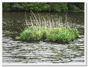
Written on: May 24th, 2017 in Outreach
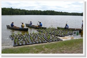
The Delaware Youth Conservation Corps preparing to install floating wetlands at Trap Pond State Park.
We’ve all heard about wetlands before but have you ever heard of a floating wetland?
Floating wetlands are artificial islands with plants on top and roots below. Similar to a natural wetland, they improve water quality by soaking up nutrients, such as nitrogen and phosphorus. These two nutrients are the primary causes of algal blooms, which make it difficult for fish and other aquatic life to survive.
Every time it rains, pollutants from lawns, roads, and other surfaces are swept into our waterways. Fortunately, we’re able to battle this runoff with floating wetlands, an efficient tool for cleaning polluted water. As the plants of the wetlands grow, they remove nutrient pollution and store it in their leaves while adding life-giving oxygen to the water. At the same time, their roots provide a home for microorganisms that feed on pollution.
The only element needed for all this to work? Simple sunlight.
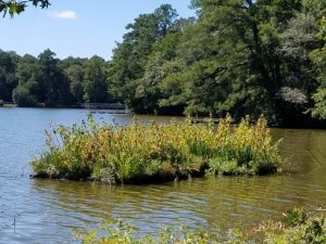
Floating wetland in the fall of season 2.
In 2015 DNREC purchased twelve floating rafts and native plants which were then linked together to form two groups of floating wetlands. The Delaware Youth Conservation Corps installed the two wetlands at Trap Pond during the Nanticoke Watershed Alliance’s annual Wade In and Nanticoke River Report Card Release event. Since then, it’s been a huge hit, not only for the students who got to install them, but also for everyone else at the park that couldn’t wait to hop in a kayak and paddle out to see them.
Over the past couple years, the wetlands have flourished and have been a destination point not only for curious paddlers but also for fisherman hoping to catch one of the many fish that find habitat in the cooler cleaner water below the raft’s root system.
Luckily, the geese have not been interested in joining in the fun. If that had occurred, there were certain plants that would have been added to deter them as well as other techniques that would have been put in place but proved not to be necessary. The turtles on the other hand, call it home –finding food and a place to sunbathe.
Floating wetland in the spring of season 3.
Due to the huge size of the pond, water quality improvement was not the intention of this project. This is simply a demonstration project that provides an opportunity for people to see what they are and learn about how they work.
Trap Pond is an ideal setting, not only because of the traffic through the park –the fisherman, paddlers, boaters, hikers, campers, students and anyone who passes them, but also because of the accessibility. To be able to paddle out and get a close up look at exactly how it’s working has been enjoyed and appreciated by the park’s visitors since the day they were installed. They’ve since been added as an educational component of the pontoon tours and canoe and kayak trips.
Stop by Trap Pond to see their progress this summer!
Delaware's Governor
State Agencies
Elected Officials
General Assembly
Delaware Courts
State Employees
Cities & Towns
Delaware State Code
State Regulations
Business First Steps
Phone Directory
Locations Directory
Public Meetings
Voting & Elections
Transparency
Delaware Marketplace
Tax Center
Personal Income Tax
Privacy Policy
Weather & Travel
Contact Us
Corporations
Franchise Tax
Gross Receipts Tax
Withholding Tax
Delaware Topics
Help Center
Mobile Apps
E-mail / Text Alerts
Social Media

Built by the Government Information Center
©MMXVIII Delaware.gov

